11/8/17: Up & Down Pattern Giving way to Cold?

EPS 42

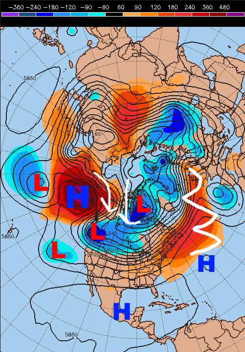
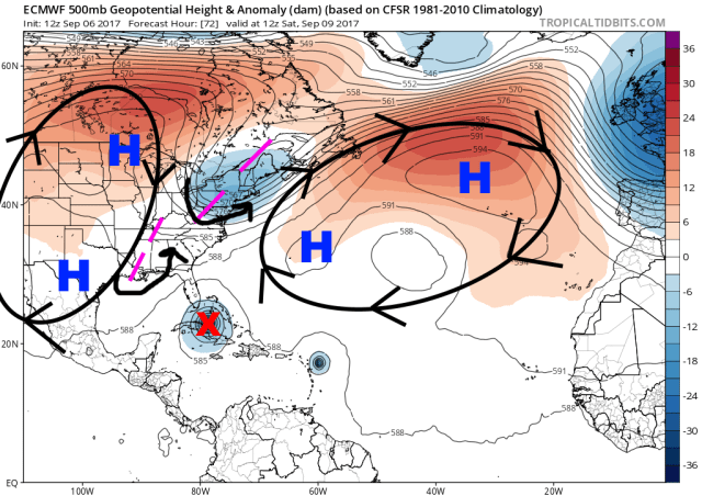
European ensemble forecast upper-level pattern for early Friday morning

Ohio saw 16 tornadoes on Sunday and damaging thunderstorm winds in excess of 100MPH, and now we’re looking forward to near-record cold for Friday!  It is certainly fall in the Great Lakes and Ohio Valley.  The late-week cold shot will be very brief, due to some flaws in the pattern if you want cold, but will also be quite intense.  A lack of blocking over the Atlantic (the North Atlantic Oscillation or NAO is near neutral) and Pacific jet hitting the West Coast fairly strong will cause moderation over the weekend and into next week, but not before we “endure” a day or two of very cold conditions for this time of year:

EPS 54 temps

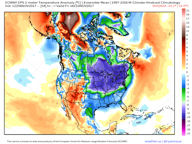
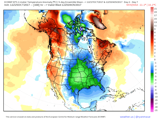
European ensemble surface temperature departure forecast valid Friday afternoon

The above map is in Celsius, meaning that anything in the blues (-8C or greater) is a departure of over 14.4 degrees Fahrenheit colder than normal, with some of the darker blues (as cold as -12C to -13C) representing air of over 20 degrees F below normal! (yes, as a meteorologist I’m rather fluid with my Celsius to Fahrenheit conversion).  This is near-record cold and will be a rude awakening for a huge portion of the Midwest, Great Lakes, Ohio Valley, Northeast, and even into the Mid Atlantic.  Despite the warmth of the last two winters, it still can (and will) get much colder than average.

NAM3 snow

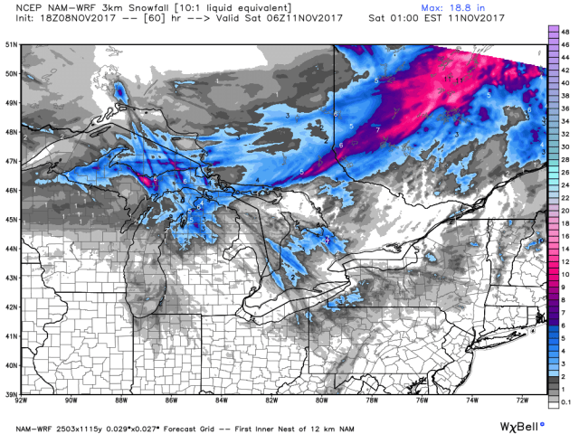
High-resolution forecast model snowfall forecast through Friday night

There will not be a ton of snow with this upcoming cold wave…outside of the lake effect Snowbelts and some of the higher terrain in northern New England where there will be a little bit of upslope snow, it will simply be “cold” but nothing more.  Parts of the Upper Peninsula and northern Lower Michigan along with parts of Ontario downwind of Lake Huron will see moderate to locally heavy lake effect, a sign of the season more than anything else.

EPS 144 500

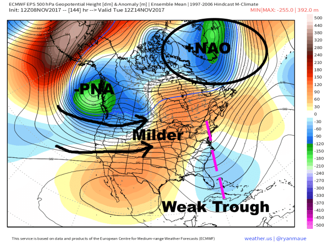
As mentioned above, the big cold won’t last all that long due to a lack of “blocking” over the northern Atlantic (the NAO will turn positive) and due to the Pacific jet flooding much of the US with milder air (due to a –PNA).  This pattern won’t be extremely warm over the east, due to the low-level cold from the weekend being a bit slow to scour out, and due to a weak trough re-developing early next week along the East Coast, but it will modify to closer to normal (which outside of the far northern tier is still too warm for snow in early to mid-November).

EPS 264 500

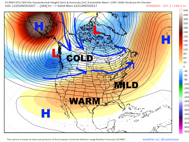
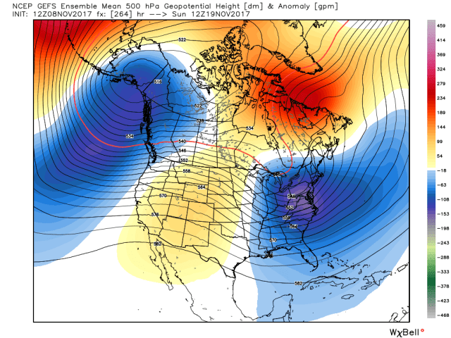
European ensemble forecast upper-level pattern valid November 19th

Our mid-range forecast ensembles have been in persistent agreement in developing a –NAO over Greenland/the Davis Strait/northeastern Canada the weekend before Thanksgiving, which adds some intrigue over the eastern US as it favors a trough near the East Coast.  This pattern still won’t be very cold at this point given an expected –PNA continuing to blast the Pacific jet into the West Coast.  This will cause much of the central US to be mild, and this will butt up against the cooler weather over the east.  Note how the air feeding into the trough over the east will be coming from southern Canada initially due to the unfavorable pattern over the western US for eastern US cold, which means that although this –NAO development will likely force temperatures near or a bit colder than normal starting the weekend before Thanksgiving, especially over the Northeast, that it won’t be THAT cold initially.

GEFS 264

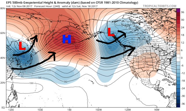
GFS ensemble forecast upper-level pattern valid November 19th

The GFS ensembles show a bit of a more favorable look with the trough centered a bit farther west, which allows for enough ridging over the western US for the eastern US trough to tap somewhat colder air.  The GFS ensembles would suggest a quicker change to farther below normal temperatures and potential snow in the interior Northeast and Great Lakes.

EPS 336 500

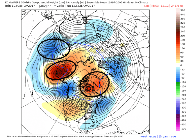
European ensemble forecast upper-level pattern valid November 22nd

The European ensembles do suggest the potential for a gradual change in the pattern by Thanksgiving that could allow colder weather into the eastern US, with the trough off the West Coast edging a bit farther northwest, allowing modest ridging to build over the western US that allows for a modestly deeper trough over the east.  The ensemble also generally maintains enough of a –NAO to help encourage the eastern US trough (though it’s not exactly a prolific block…but is a solid signal for 14 days out on an ensemble mean).

GEFS 336 500

GFS ensemble forecast upper-level weather pattern valid November 22nd

GFS ensemble forecast upper-level weather pattern valid November 22nd

The GFS ensembles remain more bullish on eastern US cold than the European ensembles, with a stronger –NAO, and with the West Coast trough backing off more, allowing for a taller ridge over the western US.  This look would be fairly cold over the eastern US near Thanksgiving and would allow for decent snow chances, especially in the lake effect Snowbelts and in the interior Northeast.

EPS GEFS 2m

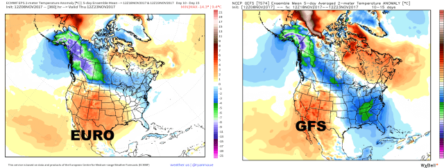
European ensemble (left) and GFS ensemble (right) 5-day surface temperature departures from November 19th-Novemebr 23rd

Both ensembles do have a cool/cold period over the east/northeast heading into Thanksgiving, but the differences in the GFS and European patterns result in a few to several degree difference in surface temperatures over the 5-day period.  The European backs the trough off the West Coast to the west slower, causing the Pacific jet to blast into the west for a longer period of time.  It also has less of a –NAO.  This results in milder air protruding farther east, and also prevents the eastern US trough from tapping as much of the cold air over the northwest portion of the continent.  Either outcome would potentially result in some snow chances over the Great Lakes and interior Northeast (especially New England), but the GFS ensemble pattern would be more conducive for snow, especially farther south.

EPS 240 500

European ensemble upper-level pattern over the Pacific valid November 18th

The big key will be when the above northern Pacific pattern breaks down or changes some; the above forecast is for 10 days out, and shows a persistent/deep trough over eastern Asia, that continuously pumps up the north-central Pacific ridge, which in turn keeps forcing a trough near the western coast of North America.  The Euro does not really break this pattern down by Thanksgiving (though does show some potential changes right at the end of the run).  The GFS ensemble does begin breaking this pattern down, allowing for more of a ridge over the west.

MJO ensembles

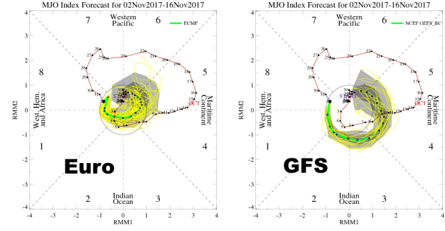
GFS and European ensemble MJO forecasts for the next two weeks

One potential cause for the difference in the handling of the Pacific pattern among the ensembles is different handling of convection in the deep tropics.  The GFS ensembles have persistently shown the MJO (Madden Julian Oscillation; a “pulse” of clouds and storms in the tropics that affects the jet stream pattern in the mid–latitudes) getting into phases 8 or 1 (both cold over the eastern US) by Thanksgiving week, while the Euro ensembles have been consistently less bullish.  The GFS ensembles have been trending towards the Euro on the MJO for over a week, so at this point I’m inclined to believe the Euro over the GFS…suggesting that while a –NAO will allow for somewhat cooler normal conditions to develop over the eastern US (especially Northeast) next weekend and through Thanksgiving, that a less than hospitable Pacific pattern will keep it from getting very cold.  With that said, we’re far enough out for some changes from both models…the idea of cooler weather is legitimate, but how cold is certainly in question (as is the amount of snow it brings).

Moving into December, the forecast pattern on the European ensemble in particular for later this month has some key similarities to my “analog” years for December.  Analog years are years that featured similar patterns in global ocean temperatures and large-scale weather patterns to this year and may give clues to how the upcoming pattern may evolve.  Here is a look at the upper-level pattern in my analog years for December:

analogs dec

Analog years upper-level pattern for December

I circled a few key areas: the higher heights from the Davis Strait east across the northern Atlantic, the higher heights over the Bering Sea points north, and the lower heights over northeastern Asia.  Here’s a look at the European ensemble mean forecast pattern valid at the end of the run (November 23rd):

EPS 360 500 circles

European ensemble forecast upper-level pattern valid November 23rd

Some differences, but the three circled areas are similar.  The difference lies in how the Euro ensemble is blasting the Pacific jet in the western US, which floods the western 2/3rds of the US with milder air.  The analogs in December were cold overall for much of the central and eastern US:

Dec analogs

Analog years mean temperature departure for December

Does this mean we’ll have a cold December this year?  Not necessarily.  BUT, some key similarities to my analog years may be developing in the high-latitudes late this month, which if they were to hold could mean colder weather is more likely than warmth in December.  This will be something I watch closely over the next couple of weeks.

So, to summarize:

-BIG cold shot late this week in the Northeast is short lived and gives way to more seasonable conditions next week

-A negative NAO will likely lead to “cooler” weather returning to the east the weekend before Thanksgiving and lasting through that week, but uncertainty over the Pacific pattern, which may remain somewhat hostile towards bigger cold, makes it difficult to say exactly how cold it will get

-Signs are starting to point towards a cold December in the central and eastern US (especially farther north), but there are some issues to work out that I’ll be watching over the coming weeks


Posted in Uncategorized | Leave a comment

11/2/17: How Long Will Warmth Last?

7 day temps

Temperature departures from normal from October 26th through November 1st

Quite a contrast the last week has been to much of the fall so far; much of the central and a good portion of the eastern United States have been colder than normal, with parts of the Ohio Valley and mid-Mississippi Valley finishing the week nearly 10 degrees colder than normal!  The northern Mid Atlantic and New England have been a notable exception, though even those areas had a couple of colder days to start the week.  Many areas saw their first frost or freeze, and parts of the Plains, Midwest, Great Lakes, and Appalachians even saw some snowflakes fly.  Unfortunately for snow lovers out there, this cold pattern has already come to an end…

RTMA temp.png

Temperatures as of 4PM EDT Thursday

Most of the big East Coast cities saw 70s on Thursday, with Dallas seeing their first 90 degree day on record in November!  The northern Rockies, Plains, and Midwest are still respectably cold, but that cold won’t effectively spill south or east anytime soon.

current 500

Current large-scale upper-level weather pattern as of Thursday morning

The current large-scale weather pattern is not too uncommon for a La Nina regime; there’s a big, blocking ridge of high pressure in the jet stream over the North Pacific, and this is sending cold air towards the northwest US and western Canada.  A ridge over the southern United States and western Atlantic is allowing very mild air to flood that region of the country.  With no blocking over the Atlantic or Arctic, this general pattern of cold in the western portions of the continent and warmth over the southern and eastern US will continue for a little while.

EPS 84 sfc

Surface temperature departures for normal valid Sunday evening

This cold in the west, warm in the east pattern is evident in the European ensemble forecast surface temperature distribution for Sunday evening, with significant cold departures over the northern Rockies and Plains, but a lot of warmth over the eastern United States.  You can see continued “warmth” near Alaska (compared to normal), signifying that the ridge there will remain and continue to pump cold into the west.  With this type of pattern, it often takes a big storm to force some cold into the east, and we will see that early next week:

EPS 96 sfc

Sea level pressure and anomalies valid Monday morning

A fairly strong low pressure will develop over the northern Plains and move into eastern Canada this weekend into early next week, with Canadian high pressure moving southeast behind it.  This will tap some cold air and send it towards the eastern third of the United States through next week.  It won’t be as cold as the recent blast, but much of the northern and eastern US will see a few days of mainly below normal weather:


EPS 264 sfc

Modelled surface temperature departure from Wednesday, November 8th through Monday, November 13th


As you can see, the coldest of the cold (by far) still remains over central and western Canada, the norther US Rockies, northern Plains, and upper Midwest, but this is a five day mean temperature departure map showing predominantly colder than normal conditions over much of the east.  Any snow threats with this will be minimal in the east, though some snow downwind of mainly the northern Great Lakes and perhaps some light snow with any system that tracks through the Northeast and interacts with this cold isn’t impossible…overall though it’s pretty early to talk major snows outside of the northern tier of the US and this airmass doesn’t look THAT cold.  In addition, the cold does NOT look to last:

EPS 264 500

Modelled upper-level weather pattern valid Monday, November 13th

The Euro ensemble mean projected upper-level weather pattern for the beginning of the following week (week of 11/13) is back to the one supporting our current warm-up; a big ridge near Alaska dumping cold towards the west, but a big upper-low near Greenland (called a positive North Atlantic Oscillation, or NAO), encouraging the cold to stay north over Canada and allowing ridging to build over the southern and eastern US…allowing warmth to return.

EPS 360 850

Modelled temperature departures from November 13th through November 17th

The resulting modelled temperature departures for the week of the 13th show warmth gradually building east.  There’s some lingering cold in the Northeast to start the week, but warmth is dominating a large portion of the US.  This is 11-15 days in the future, and is an ensemble mean of 51 different ensemble members, so there’s some variation and it’s possible that another little lobe of cold drops in somewhere…but the overall theme here is that outside of the northern Rockies and Plains cold will be hard to sustain as we head through early and mid-November.

OLR time long

“Outgoing Longwave Radiation” near the equator over the last year, showing where areas of thunderstorms (blue) have been most persistent

As mentioned earlier, the ridging over the North Pacific is a classic La Nina signature, and occurs due to enhanced thunderstorms near the equator occurring from near Australia into the western Pacific.  These thunderstorms release massive amounts of heat into the upper-levels of the atmosphere, and help to determine where the jet stream lies and how strong it is as we head into winter.  The above plot is a quick way of ascertaining where these thunderstorms are most persistent, as the cloud tops are colder than the ocean surface and give off less radiation.  The areas of blue represent persistent thunderstorms near the equator.

In an El Nino these thunderstorms occur farther east (of the Dateline or 180 degrees longitude) due to warmer waters over the central and eastern equatorial Pacific.  In a La Nina these occur farther west.  Note how this fall has featured thunderstorms in a similar area to last fall and winter (also a La Nina), along with a lack of thunderstorms (warmer colors) near and east of the Dateline.  Last winter featured a lot of ridging over the North Pacific, and a lot of warmth over the central and eastern US:


16-17 500

Average upper-level weather pattern from December, January, and February of 2016-17


That ridge is located a bit farther south than we’re currently seeing, but the similarities in the patterns are uncanny.  Last winter was VERY warm over much of the central and eastern US.  This recent pattern has caused some concern for a repeat this winter, and given some similarities (La Nina winter, similar thunderstorm placement in the tropics early on) those concerns aren’t unfounded.  However, there are some signs that this winter will be DIFFERENT:


SST diff

Sea surface temperature difference from October 2016 to October 2017


This year’s La Nina features warmer waters near the Dateline…and colder waters near Australia when compared to 2016 in October.  This may still change as we head into winter, but suggests that thunderstorms may not be as tied to the region near Australia this winter and may have some tendency to come east at times.  In fact, a fairly strong “Madden Julian Oscillation” or “MJO” recently progressed east, and contributed to the recent cooldown over the central and eastern US:


recent MJO

MJO phase and magnitude over the last 45 days)


The MJO is a large-scale circulation in the tropics that moves over the warm waters, influencing where those important tropical thunderstorms occur and having well-known impacts on the jet stream farther north.

The strong MJO through phase 7 and 8 (after moving through phases 5 and 6) is a bit of a departure for normal La Nina activity, and the MJO phase correlations to US temperatures centered on the October-November-December period match warmth in phases 5 and 6 followed by cooler conditions:

MJO correlation

MJO phase correlation to October-December temperatures in the US

As the MJO weakens and moves towards/into the “circle of death,” the pattern is returning to one more typical of a La Nina, with ridging over the North Pacific, a western US trough and cold, and a Southeast Ridge and warmth.  With the discussion of potential enhanced MJO activity above, should the sea surface temperature differences from last year persist, let’s look at the MJO forecasts moving forward from the GFS (American model) and European model ensembles:

MJO forecasts

European and GFS ensemble MJO forecasts for the next two weeks

Although they have somewhat different ways of getting there, the GFS and Euro ensembles both hint at another potential MJO pulse towards phases 7 and 8 for the second half of November.  This has been hinted at for over a week.  This is still a long ways out and may change, but given the recent strong MJO that made it into phase 8 to go along with decent model agreement and persistence for such a long lead time, this is something to watch.

In general, I don’t expect substantial changes to the pattern until potentially Thanksgiving week.  The MJO will be weak, and the La Nina pattern with the north Pacific ridge and Southeast US Ridge will persist.  Brief cooldowns will be possible in the eastern US, but nothing too significant or sustained.  We will watch for changes in the tropical thunderstorms and north Pacific pattern towards late November.

Posted in Uncategorized | Leave a comment

10/25/17: Colder Pattern to Linger?

Oct to date

Month to date temperature anomalies for October.

Winter weather lovers have suffered through a very warm start to the fall so far; temperatures across almost the entire eastern United States have been 5 to 9 degrees warmer than average for the first 24 days of October after a very warm September.  The leaves have been slow to change, many areas haven’t seen frost yet, and don’t even think about snow.

EPS 168 2m

European model ensemble surface temperature departures from Friday morning through Wednesday morning.

The good news?  A cooldown is finally affecting parts of the central and eastern United States, with many areas poised to see several days to a week of mainly below normal temperatures.  An exception will be New England, as the initial cold is dumping in too far west to cool them off for a prolonged period of time.

EPS 120 500

European model ensemble forecast upper-level weather pattern valid Monday morning.

The main source of the incoming cold air will be a very large ridge in the jet stream over the West Coast and into northwestern Canada and Alaska; this will cause the jet stream to cascade down over the Rockies and into the Plains, bringing some very cold air with it.  In mid-winter, when the “wavelengths” or distance between ridges and troughs is longer, this would probably result in a colder pattern for the East Coast than what we’ll see over the weekend and into next week.  However, since it’s not yet mid-winter, and because the North Atlantic Oscillation, or “NAO,” is not strongly negative, this upcoming cold will be centered over the central part of the country with only some of it getting to the East Coast at times over the next week.

GFS snow 12z

GFS model snowfall through Saturday, November 4th.

This blast of cold will result in a lot of areas in the central and interior eastern US seeing their first freeze or frost, and some snow, especially over the Upper Midwest and northern Great Lakes.  In the east, since the expectation is they’ll mainly be seeing “leftover” cold from the Midwest, snow will likely be confined to the higher terrain and be spotty at best in the short to medium range.

How Long Does This Pattern Last?

EPS 240 500

European ensemble forecast upper-level weather pattern for November 4th.

There won’t be a huge pattern change anytime soon, as there’s good agreement on the large ridge over the west and into Alaska (called a –EPO) remaining in place.  Despite the large and persistent –EPO ridge, it still doesn’t look like the eastern US will be particularly cold; this is due to how far west the ridge is, with the coldest of air dumping into the Rockies and northern Plains.  With no real –NAO (it’s neutral at best in this projection) there’s nothing to force cold into the east, so the trough over the western US encourages a weak Southeast Ridge to crop up.  Obviously, some changes could get cold into the east with this type of –EPO pattern, but at this point my bet is the east reverts back to a milder (but not extremely warm) pattern after next week, with the northern tier and west running colder.  Northern New England and Upstate New York could be far enough north to contend with the colder weather and perhaps some wintry precip threats.

EPS 360 500

European ensemble model projected upper-air pattern for November 9th.

This pattern is expected to have staying power as we head towards mid-November, with the –EPO remaining very persistent but the Atlantic side not cooperating for eastern US cold.  This is a pretty common pattern as we head into La Nina winters, with cold dumping into the west and warmth over the east (especially southeast).  The persistent –EPO is a good sign, as if we keep that towards winter as the wavelengths get longer, cold would eventually get into the east at times.  In the shorter term though, signs point against persistent cold over the east.

EPS 2m temps

European model ensemble projected surface temperature departures from November 4th through 9th.

The surface temperature departures reflect the amount of cold expected to be forced south on the east side of the –EPO, and also hints at the potential Southeast Ridge development.  Winter lovers in the east won’t want to hear this, but when the west is that cold, it is hard for the east to be cold unless there’s a –NAO.  That’s why I’m in general agreement with the mild start to November (after lingering cold for the first few days) in the east, though with so much cold lurking just to the northwest some occasional cooldowns behind any larger storms would be likely.  It won’t be persistently warm, and a fluky snow event can’t be ruled out in the higher terrain or interior Northeast well inland from the coast, but there may be 3 or 4 warmer days for every colder day in this type of pattern.

ECM MJO

European ensemble MJO index forecast for the next two weeks.

Large areas of thunderstorms in the tropics are a key driver to the jet stream during the second half of fall and winter, and an index that measures atmospheric factors that influence those complexes of thunderstorms is called the “Madden Julian Oscillation” (or MJO).  The MJO has well known correlations to the mid-latitude weather pattern; for instance, phases 6 is typically warm this time of year in the central and eastern US, while phases 7 and 8 are colder (though with some hints of a Southeast Ridge):

MJO correlation

Typical temperature correlation over the continental US in the various MJO phases.

Though these correlations are by no means perfect, the MJO has done a good job of predicting the recent change from warmer to colder, and even does a good job of suggesting the coldest of the cold centered over the northern Rockies, Plains, and Midwest, with some trouble getting it into the east.

The forecast is for the current MJO wave to weaken during early November, perhaps suggesting the already La Nina-like pattern will remain locked in place for a little bit.  My current guess at this point is that we see some semblance of a –EPO continue through at least mid-month, with colder temperatures focused in the west and a Southeast Ridge trying to keep the east warm.  It wouldn’t surprise me if the Southeast Ridge expands a bit between November 10th and 20th, keeping the eastern US on the mild side.  After that, we’ll watch for perhaps a change in the pattern as we near Thanksgiving.


Posted in Uncategorized | Leave a comment

Thursday Evening Irma Update: Category Five Hurricane Tearing Through the Turks and Caicos, and Towards the Bahamas and Southeast US

Irma IR

Hurricane Irma has remained an extremely impressive hurricane, and despite a bit of weakening is still a category 5 hurricane this evening with maximum sustained winds of 175MPH.  Irma is bringing these destructive winds to the Turks and Caicos as of this writing, and unfortunately scenes like what have come out of the northeastern Caribbean Islands will likely come out of this region.  Irma will continue moving west-northwest over the next couple of days, taking the storm into parts of the Bahamas, close to the northern coast of Cuba, and then towards Florida.  Here’s the National Hurricane Center forecast as of 8:00PM EDT Thursday:

Irma NHC

Take Home Messages:

  1. After the Turks and Caicos, Irma will pass over the southeastern Bahamas on Friday as an extremely dangerous category 5 or 4 hurricane. Preparations to protect life and property should be completed.  Any islands that get into the core of Irma will contend with destructive winds and a life threatening storm surge.  Due to Irma’s large size, less severe but still dangerous conditions will occur well away from the center of the storm.
  2. Irma will sharply turn to the north on Saturday. Where exactly this occurs will have significant implications for both the rest of the Bahamas and Florida.  The general trend today has been for the turn to occur a bit farther southwest, putting southern Florida at increased risk for severe impacts.  Regardless, Irma has a large circulation and the Bahamas will be on the stronger side of the storm, so severe conditions could still affect the islands.  A shift back to the northeast, taking the core of Irma very near or over more of the Bahamas, is still within the margin for error at this point.  Because of this, preparations should continue to be in earnest across the Florida Peninsula and Bahamas.  Irma will likely remain at least a category 4 hurricane up until a potential Florida landfall.  Heed all evacuation orders.
  3. Due to Irma’s large size and expected intensity at landfall in southern Florida, the storm will likely be slow to weaken as it moves north. Inland impacts from flooding rains and damaging winds are possible in all of the Florida peninsula, along with a life-threatening storm surge up either coast.  A track near or up either coast as opposed to up the center of the peninsula is also possible, which would slow weakening of the storm.  Heed all evacuation orders.
  4. Irma still poses a threat to the Southeast; whether the storm hits Florida and makes it up in a weakened (but still dangerous) state or stays just east of Florida and hits Georgia or South Carolina head on as a stronger storm. Due to Irma’s large size, significant inland impacts would also be possible with either outcome.  Preparations should continue across the Southeast for Irma.  If you are ordered to evacuate, heed that order.

National Hurricane Center: www.nhc.noaa.gov

US National Weather Service: www.weather.gov

Useful website including forecast models and aircraft recon: www.tropicaltidbits.com

Irma microwave

Irma has finally weakened a little bit today, likely due to a little bit of interaction with the mountainous Hispaniola and also inner core changes.  The above microwave satellite image reveals that Irma’s inner eyewall has perhaps degraded some (and is not completely closed), while an outer eyewall has developed.  Irma has not undergone an eyewall replacement since it rapidly intensified to a category 5 hurricane Tuesday morning, but appears to be trying to undergo one now.  If the eyewall cycle actually occurs this time (there have been at least a couple of false starts), the hurricane would perhaps weaken a bit and expand initially.  If the eyewall cycle completes, the new inner eyewall could perhaps allow for re-intensification.  In short, Irma may fluctuate in intensity over the next day as the inner core of the storm tries to work itself out.  This is little consolation to the Turks and Caicos and southeastern Bahamas, as Irma will be an extremely strong storm regardless of these inner core changes.

Irma WV

The main players steering Irma over the next several days are already present on water vapor imagery.  Irma is still being steered by ridging over the sub-tropical Atlantic.  This ridging extends west to near Florida, though may be eaten away some by the weekend as the trough over the Plains dives southeast.  Irma will continue moving west or west-northwest until it runs into the western edge of the ridging.  If nothing changed now that’d cause a turn to the north near the Keys…but with the incoming upper-level energy expected to eat away at the western edge of the ridge Saturday and Sunday, that turn will likely occur a bit farther east.  Exactly how quickly the ridging gets eaten away at, and how far west Irma gets before the turn occurs are important.

Irma EPS comparison

When comparing yesterday afternoon’s European ensemble to this afternoon’s valid Saturday morning, the trough over the Northeast is perhaps just a bit quicker to be moving east, but any difference is very small.  Note how the little kink in the isohypses (lines of equal geopotential height) over the south is located over Arkansas and Louisiana on Thursday’s run, but over Alabama and Mississippi on Wednesday’s run.  This is the energy diving SW out of the Plains that will cause Irma’s turn and pick it up over the weekend.  If this piece comes in slower and farther west, Irma gets a bit farther west before the turn, especially with no substantial trends with the Northeast trough.  Still a bit early to know for sure precisely how Irma interacts with this trough, so some changes may still occur.

The GFS and its ensemble have generally been farther east with Irma over the last couple days of runs, threatening the Southeast more than the Florida peninsula.  The Euro and its ensemble have consistently been farther west with Irma, threatening the Florida peninsula more.  Although the future path of Irma is not yet known, check out how the two models have been doing with the track so far:

GFS:

Irma GFS trend

The GFS has consistently been too far northeast with Irma’s short term track, and the last few runs have shown the turn occurring farther southwest, bringing the threat closer to Florida.

Euro:

Irma Euro trend

The Euro hasn’t had much of a bias in the short term with Irma over the last couple days’ worth of runs, and was initially farther southwest than the GFS.  The Euro has, despite starting farther southwest, also trended a bit farther southwest with its recent runs.

Due to the incoming trough being a bit slower (and due to no help from the Northeast trough), and the short term motion continuing to follow the southern Euro, the farther southwest and delayed turn trend in the guidance today seems legitimate.  There is still time for additional trends, either way, but the chances for Irma to miss Florida to the east appear to be diminishing.  This may be better news for the northern Bahamas, though persons on those islands should continue preparations, as it wouldn’t take much of a trend back the other way to bring severe conditions to the northern Bahamas…and indirect impacts from heavy rain, wind, and some storm surge are likely unavoidable due to Irma’s large size.

Irma GEFS tracks

The GFS ensembles, like the operational model, have trended west today.  There’s still spread from the Carolinas to just west of Florida, but the mean has trended west.  Again, due to the incoming trough being a bit slower and Irma’s farther south track in the short term, this trend seems reasonable, and puts Florida in a likely position to be hit directly.  Significant impacts would extend north into the Southeast, especially Georgia and South Carolina, with many of these potential tracks.  I will say that the two members that are far northeast and hit eastern South Carolina and one that goes over the Outer Banks and into the Mid Atlantic appear extremely unlikely, as there’s little evidence of the northwest motion they have over the next 24-48 hours being likely.

Irma EPS tracks

The European ensembles are really zeroing in on Florida today, continuing the western trend noted yesterday.  Several members do still miss Florida just to the east and then get up to Georgia or South Carolina, but the number of members out there have diminished since yesterday.  If trends for the incoming trough don’t speed up, and if Irma doesn’t start following the northern side of guidance soon, then this outcome becomes less likely.  I don’t want to rule it out, but we’d need to see those changes occur within the next day.  If they don’t occur, then we appear locked and loaded on a direct Florida landfall.

I’m still skeptical of this turning due west into Cuba, as the ridging doesn’t appear that strong, but a good number of members still show that, and given the implications for Cuba and the intensity as Irma heads north towards the US that’s something we’ll have to continue to monitor.  Hopefully the Cuba questions are answered over the next day.

Irma GFS 200 60

I am very concerned about Irma’s intensity if it hits Florida Saturday night or Sunday.  Some signs are pointing to a period of intensification as the storm turns north Saturday into Sunday.  Above is a look at the GFS model upper-level winds valid late Saturday night.  The right entrance quadrant of a jet streak is located just north of Irma; this would eventually cause shear to impact the core of Irma as it turns north, but would potentially lead to intensification due to outstanding upper-level ventilation before the shear gets to the core of the hurricane.

Irma SST

In addition, the waters as Irma approaches Florida are some of the warmest in the Atlantic basin, and are a little bit warmer than the waters Irma has been over thus far as it’s become and maintained category 5 intensity.

All told, Irma may fluctuate in intensity over the next 12-24 hours as the inner core structure/eyewall cycle work themselves out in an otherwise favorable environment.  Irma should remain a category 4 or 5 storm as it moves west-northwest towards the Florida straight.  If Irma hits Cuba, it would potentially weaken below major hurricane strength, which is probably the best bet for southern Florida (Cuba would take one on the chin though).  There would be some opportunity for re-intensification between Florida and Cuba, but overall a Cuba landfall would still result in a weaker hit for Florida than if Irma stays over water.  If Irma stays over water, I expect it to be a category 4 as it heads into the Florida straight.  Whether or not the favorable upper-level winds and water temperatures for intensification result in a bump back up to category 5 or not will depend on proximity to Cuba and Irma’s inner core structure at that time.  Basically, it’s too early to say.  However, the potential for a category 4 or 5 hurricane hit on Florida is distinctly there.

If Irma, by some stroke of luck, turns just east of Florida, it would experience shear as it moved north towards Georgia or South Carolina and would slowly weaken, but would still potentially be a major hurricane at landfall.  So basically, we’re looking at a severe hurricane hit wherever Irma hits the US, unless Cuba takes the brunt of the storm first and weakens it at least somewhat.

Irma ECM wind swath

If the track up Florida pans out, the potential would exist for tens of millions of people to be threatened by damaging winds.  This is the European model forecast wind gusts; it landfalls in southwestern Florida and tracks up the spine of Florida into Georgia.  Anything in red is hurricane force gusts or stronger on the model; the browns represent gusts on the order of 80-100MPH, the whites and reds represent 100MPH++ gusts.  This would cause a lot of damage and millions of power outages, along with storm surge along a lot of coastline.  This is just one model projection and may be wrong, but illustrates the power of Irma and how impacts will extend well away from the landfall location.  If Irma stays east of Florida and hits Georgia or South Carolina, the swatch of whites and reds corresponding to 100MPH++ gusts would likely extend straight up into those areas.  This will be a bad storm wherever it ends up going in the Southeast US.  Note how this western track causes more moderate wind impacts in the northern and western Bahamas, but the destructive winds are still very close.  This will likely adjust some as we get closer, so anyone anywhere near the projected path needs to prepare for impacts until told to do otherwise.

Irma QPF

Due to Irma’s large size, it will bring a lot of rain along with a potential for freshwater flooding for a lot of areas.  Above is the current projected rainfall through Thursday evening, with a large portion of the Southeast and southern Mid Atlantic seeing enough rain to cause flooding issues.

There’s still time for Irma’s exact track to adjust, which will have large impacts in the Southeast US and Bahamas.  A large area will be subjected to damaging winds and potentially flooding rain, with storm surge along a large section of shoreline.  It’s too early to pin down who will see the worst impacts, but preparations should be ongoing in all of the Florida Peninsula, Georgia, South Carolina, and North Carolina.  Heed the advice of local officials as we continue to refine the exact track of Irma over the next couple of days.  This will be a doozy.

Posted in Uncategorized | Leave a comment

Wednesday Afternoon Irma Update: Category Five Storm Barreling Through the Virgin Islands, Towards Turks and Caicos; Threat to Bahamas and Southeast Remains

Irma vis.png

Hurricane Irma remains an extremely impressive storm, with a large and distinct eye surrounded by a very intense and complete eyewall.  Irma is a very large storm, and has already done extensive damage in the Leeward Islands and Virgin Islands.  Irma has maintained incredible 185MPH sustained winds for over 24 hours now, and isn’t showing signs of weakening soon.  Here is the latest forecast from the National Hurricane Center:

Irma NHC

Take Home Messages:

  1. Irma has battered the northern Leeward Islands and northern Virgin Islands with category 5 hurricane conditions, and is bringing inclement weather including damaging winds, flooding rain, and storm surge to Puerto Rico and the southern Virgin Islands now. Remain in a safe place in these areas until the weather improves tonight into Thursday.
  2. Although the center of Irma will likely stay north of Haiti and the Dominican Republic, impacts are still likely. Flooding from heavy rain in the mountainous terrain will be the main risk with Irma in Hispaniola, though damaging winds and a dangerous storm surge are also possible, especially near the northern coast.  Follow the advice of local officials and stay safe.
  3. Irma’s next direct impact is expected to be in the Turks and Caicos as a large and extremely dangerous category 4 or 5 hurricane. Hurricane Warnings are in effect, and preparations need to be rushed to completion today.  Destructive winds, significant storm surge, and flooding from heavy rain can be expected in parts of the Turks and Caicos.  The southeastern Bahamas will also be dangerously close to or perhaps within the core of the hurricane on Friday.  Follow any advice from local officials and stay in a safe place while the hurricane passes.
  4. The threat level for the rest of the Bahamas and Florida will ultimately depend on where Irma makes its much anticipated turn north on Saturday. It is too early to pin down where exactly that occurs, though many of our models continue to target Florida.  Preparations should continue in all of the Bahamas and the Florida Peninsula, as further track adjustments can be expected, meaning it’s too soon to say for sure which areas will see severe impacts and which areas will not.  Regardless, Irma remains a threat to these areas and you should follow the advice of local officials, and evacuate if ordered to do so.
  5. Irma may stay on a northward heading for a prolonged period of time, which would put the Southeast at risk if the turn occurs just southeast of Florida, allowing for a track near or just off of the east coast of Florida. Because of this, Georgia and the Carolinas, especially South Carolina, need to closely monitor the progress of Irma.  Make sure you have a hurricane plan in place that can be executed within the next couple of days if Irma looks to impact the Southeast.  There is still a small but non-negligible chance that Irma stays just east of the US coastline and curves out to sea.  The odds of that occurring are continuing to slowly decrease.
  6. Irma will be a very large and powerful storm, meaning impacts will occur well away from the center. If Irma makes landfall in the US, significant inland impacts from flooding, tornadoes, and perhaps an inland damaging wind threat would be likely.  The impacts could extend well inland, and potentially into regions well away from the initial landfall point such as the Mid Atlantic and Appalachians.  Because of this, and the potential large track forecast error for a hurricane 4-5 days out, it is important not to focus on the center line of the forecast.

National Hurricane Center: www.nhc.noaa.gov

US National Weather Service: www.weather.gov

Very useful website, including model data and airplane recon data: www.tropicaltidbits.com

Irma radar

For the first time in Irma’s life we have a National Weather Service radar within range of the storm, and as expected it has revealed a very impressive storm structure.  Irma’s eyewall is very intense and completely closed, which is to be expected with a category 5 hurricane.  Thus far, Irma has maintained its extreme intensity for over 24 hours with no eyewall replacement cycle to cause at least temporary weakening.  There are some signs on radar that the inner rain bands may be attempting to consolidate into an outer eyewall, which would trigger an eyewall cycle, though at this time it’s not imminent.  This means that in the short term there won’t be a weakening of Irma due to inner core dynamics, though it could happen later tonight or Thursday.  Other than inner core dynamics, let’s look at the waters that lay ahead of Irma:

Irma SST

That’s right, they only get warmer as Irma heads towards the Turks and Caicos and the vicinity of northern Cuba or southern Florida.  In addition, mid-level dry air is expected to stay well away from the hurricane for the next few days:

Irma GFS RH 60

Irma’s very large moisture pouch and a lack of substantial wind shear should make sure dry air intrusions into Irma are kept to a minimum.  All of this, combined with continued favorable upper-level winds (in part due to the storms large size and intensity causing a positive feedback with good upper-level exhaust) will allow Irma to remain a powerful category 4 or 5 hurricane into the weekend.  The only potential impediment is interaction with Cuba, which remains a possibility.

Irma ECM 72

As for where Irma will go, the track forecast philosophy hasn’t changed much.  Irma will continue on a west-northwest heading through the end of the west on the periphery of sub-tropical ridging across the central Atlantic.  The storm may even get a brief nudge closer to due west by the ridging Friday into Saturday, taking it very close to Cuba.

By the weekend, pictured above being Saturday morning, Irma reaches a large weakness in the ridging caused by two troughs; one over the Northeast, one over the Mississippi Valley.  This will cause Irma to slow and turn rather abruptly more to the north on Saturday and Sunday.  As has been stressed over the last couple of days, where this turn occurs is VERY IMPORTANT for both the Bahamas and the Southeast US, especially Florida.  The location of the turn and sharpness of it will be driven by both the size of the weakness, a function of the troughing north of the hurricane, and the location of the hurricane itself, a function mainly of the hurricane’s track through the end of the week.

Irma EPS comparison

When looking at the European ensemble mean pattern, and comparing it to yesterday’s run valid at the same time (Saturday morning), it appears that today’s run has just a little bit less of a trough over the Northeast, and perhaps a bit more ridging over the Atlantic.  The difference is very small.  Something important that has consistently happened though is Irma has stayed on the southern side of the track guidance over the last several days.  The longer this occurs, the less likely a sharper turn to the north and track out to sea is, especially since the trough in the Northeast today isn’t trending stronger or farther south.

Irma GEFS

Above is a look at the GFS (American model) ensemble forecast tracks for Irma on its run from early Wednesday afternoon.  This ensemble can be under-dispersive, as in the actual outcome is outside of its range of solutions; with that said, you can see how where the turn occurs is very important.  A difference of 50 miles (which is small when talking about hurricane location 4 days out) may mean the difference between a hit on western Florida, Miami, or staying just east of Florida.  It should be noted that the GFS ensemble last night were farther east, and this run has drifted back west.

Irma EPS tracks

The European model ensemble tracks have a little bit more spread, though they perhaps focus on an area a bit farther west than the GFS ensemble.  Last night, more members missed Florida to the east, so although not as drastic of a shift as the GFS, the European ensemble has also shifted a bit west today.  For the first time out of any runs on Irma, no ensemble member completely misses the US; the farther east member still hits the Outer Banks.

Note how some of the GFS and European ensemble members have a little bend to the “left” or NNW over Florida or near Georgia; this is due to the second, weak trough over the Mississippi Valley.  This trough may initially cause an initial bend to the NNE when Irma is south of the trough, and then a small bend back to the N or NNW once Irma is north of the trough.  Where these small bends occur is unknown, as the location of that weak trough has continued to bounce around on the models.  With that said, if Irma is riding up either coast of Florida or towards the Southeast, where one of those bends occurs could ultimately determine the landfall location.

All in all, given the lack of positive trends with the Northeast trough and Irma’s continued insistence to lean towards the southern side of the track forecast over the last few days, the odds of an out to sea solution have probably gone down today, and the outcome, while still not impossible, is a long shot at best.  A hurricane landfall in the United States is likely.  Where is still unknown; Florida continues to be highlighted as a likely initial target late Saturday or Sunday, however, where the turn occurs is less than certain.  Due to the sharpness of the turn, until we nail that down its hard to highlight which specific areas are more likely to see a direct landfall.  Due to the storm’s expected near due north motion after it turns, Georgia and the Carolinas may also end up in the line of fire Sunday or Monday and need to monitor Irma closely and make sure they’re prepared should the storm turn their way.  The exact location of the turn will also impact how much Irma affects the Bahamas.

Potential land interaction with Cuba continues to throw some uncertainty into the intensity forecast.  If Irma isn’t significantly impacted by Cuba, it will remain a very powerful hurricane through the weekend and up to a potential US landfall.  Cuba would weaken the storm if Irma tracks over it, however, some re-intensification would be possible as Irma turned north and moved back over water before hitting the US.  Irma should remain a large hurricane regardless of its exact intensity.


Posted in Uncategorized | Leave a comment

Tuesday Evening Irma Update: Irma now a Potentially Catastrophic Category Five Hurricane Moving West-Northwest

Irma IR

Hurricane Irma has continued intensifying over the last day, and is now one of the strongest Atlantic Ocean hurricanes on record with maximum sustained winds of 185MPH.  Irma remains a large hurricane, and is approaching the Leeward Islands.  Devastation is likely on any islands that manage to get into the core of Irma.  Here is the latest official forecast from the National Hurricane Center:

002047_5day_cone_no_line_and_wind

Take Home Messages:

  1. Irma will pass through the northern Leeward Islands and the northern Virgin Islands as a catastrophic category 5 hurricane tonight through Wednesday. All preparations to protect life and property in these areas should be completed, as conditions will be quickly going downhill this evening.  Destructive winds and life-threatening flooding from storm surge and heavy rain can be expected in the northern Leeward Islands and northern Virgin Islands over the next 24 hours.  Stay safe and follow the advice of local officials.
  2. Puerto Rico and the southern Virgin Islands will feel significant impacts as Irma goes just to the north late tonight through Wednesday night. Hurricane Warnings are in effect.  Damaging winds and life-threatening flooding from storm surge and heavy rain can be expected in these areas from late tonight through Wednesday night.  Preparations to protect life and property should be completed this evening as conditions will be going downhill quickly by sunrise Wednesday.  Follow the advice of local officials.
  3. Significant impacts are expected in Haiti and the Dominican Republic are Irma passes just to the north. Life-threatening flash flooding due to Irma’s large size and the mountainous terrain is expected to be the primary hazard, though damaging winds and dangerous storm surge are also expected, especially near the northern coast of the island.  Hurricane and Tropical Storm Watches and Warning are in effect.  A more direct impact still can’t be ruled out.  Preparations to protect life and property should be completed soon, as conditions will go downhill quickly starting late on Wednesday.  Follow the advice of local officials.
  4. Irma will pass through the Turks and Caicos as an extremely dangerous category 4 or 5 hurricane Thursday and Friday. Hurricane watches are in effect.  Preparations to protect life and property should now be underway in these islands, as destructive winds and life-threatening flooding due to storm surge and heavy rain will accompany Irma.  Impacts remain likely in the Bahamas and preparations should be underway, though it’s still too early to know how Irma will track through the nation.  Follow the advice of local officials as the storm approaches.
  5. Irma continues to threaten the Southeast, particularly Florida. Though the exact landfall region is still unknown, you should begin to put your hurricane plan in place in Florida and the Southeast in case the storm threatens your area.  Again, it is too soon to know where exactly landfall may occur, and the storm missing entirely to the east with just fringe impacts still is possible, though not likely.  A credible threat of a strong hurricane landfall exists in the Southeast over the weekend, especially in Florida, so you should begin to prepare for the possibility and closely monitor the forecast for Irma.  Impacts may extend well away from the initial landfall location.  Follow the advice of local officials and evacuate if told to do so.  Even if the worst of Irma doesn’t impact your location, Irma is a very strong storm, so making preparations now is the course of least regret and may ultimately save lives wherever landfall occurs.
  6. In all regions that Irma ultimately impacts, the storm is expected to be very large, with impacts extending well away from the center. You should prepare for impacts, even if the center line of the forecast isn’t right over your head.

National Hurricane Center: www.nhc.noaa.gov

US National Weather Service: www.weather.gov

Useful website with forecast models and aircraft recon data: www.tropicaltidbits.com

Irma HWRF 12

First off, this “serious” situation in the northern Leeward Islands discussed yesterday has become downright frightening, as Irma is now one of the strongest hurricanes on record for the Atlantic basin and will pass through tonight.  The above image from one of our more reliable hurricane models shows Barbuda in the inner core of a category 5 hurricane tonight, getting lashed by violent winds.  The core of violent winds is heading towards Anguilla and St. Martin, with damaging hurricane force winds in the purple extending farther south than that.  The green represents tropical storm force winds, which will affect a number of islands tonight into Wednesday morning.

Irma HWRF 21

Irma is expected to continue to chug west-northwest and pass through the northern Virgin Islands on Wednesday, with the core of the destructive category 5 storm expected to impact the Virgin Islands.  Puerto Rico and the southern Virgin Islands will see more of a fringe impact, but will still see adverse and potentially dangerous conditions regardless, due to Irma’s large size.

Irma GFS 60

The forecast upper-level weather pattern from the American GFS forecast model valid Thursday night is pictured above.  The players steering Irma over the next several days, and ultimately controlling where/if the storm hits the US, have not changed, and neither has the forecast over the next couple of days.  Irma will remain on a west-northwest heading, likely staying just north of (but still bringing impacts to) Puerto Rico and Hispaniola, and then heading into the Turks and Caicos.  The models have edged north just a little bit through this portion of the forecast since yesterday, but not enough to significantly change the forecast for any of these areas.

Irma will be steered in a continued west-northwest direction through the end of the week on the southwestern periphery of a sub-tropical ridge located over the central Atlantic.  By the weekend, Irma will approach the western edge of the ridge, with a trough over the eastern US attempting to eat away at the western portion of the ridge.  This should cause Irma to slow as it reaches these weaker steering currents by later Friday and Saturday.  If the trough over the eastern US moves east quickly enough and the ridge builds back in, Irma would not have an escape route out to sea.  However, another weak trough (circled over the northern Plains in the above image) dropping southeast towards the Mississippi Valley will keep a weakness in the ridge somewhere to the north of Irma…so, even if Irma misses the East Coast trough, the storm will still likely turn north but do so farther west.

Irma EPS 96

Looking ahead to Saturday morning, on the European model ensemble, it’s evident why it’s still too early to declare where a US landfall will occur, as Irma will be approaching a bit of a dead zone in the steering currents.  The black arrows represent some of the steering around Irma.  Irma will be west of the west-northwest steering from the ridge to its northeast, it will be east of the southern steering from the ridge well to its west, but also south of the influence of the trough(s) to its north.  If Irma is located even 100-200 miles farther north at this point, and the pattern shown is relatively accurate, it does have an escape out to sea.  Since Irma is located a good bit farther south, it doesn’t get as much of a tug from the Northeast US trough and instead just slows down.

Irma EPS 120

As we move the European ensemble ahead to Sunday morning, the trough and escape route out to sea are beginning to pull away from the East Coast, with Irma on the ensemble mean located near southern Florida.  How far south the trough extends and where exactly Irma is located at this point is very important, as that will determine where Irma turns north and determines if Irma will go into Cuba and then maybe the Gulf, hit Florida, the Southeast, or stay just off the Southeast US coast.

If the trough is located a bit farther south, or if Irma is say located east of Orlando off the coast at this point, the escape route still hasn’t closed.  If Irma is located where the ensemble mean has it, and the trough is where it is or even farther northeast, Irma hits Florida or gets into the eastern Gulf.  A scenario in between is also possible.  The small upper low over the Deep South will likely limit how far west Irma can get if the storm goes into the Gulf.

Irma EPS comparison

A complicating factor today is that there is some disagreement on how far south Irma goes over the next few days…for example, the GFS keeps it well north of Cuba, and the Euro takes it straight into central Cuba.  In addition to that disagreement, there’s been at least a subtle trend in all guidance for the Northeast trough to move out just a little bit slower.  Compare Monday afternoon’s Euro ensemble mean to Tuesday afternoon’s run…there’s just a little more blue with the trough extending farther south, meaning that on the mean the ensemble has a deeper trough in that area.  That could keep the door for an escape open just a little bit longer.

Irma EPS tracks

Unfortunately, today’s ensemble spread remains fairly large after about 3-4 days out.  Disagreement starts north of Hispaniola, with big disagreement over where Irma’s north turn occurs.  The location of this turn is influenced by Irma’s short term track and how long the trough takes to exit the Northeast.  Because of this, it’s still too early to nail down exact impacts in the Bahamas, and also to determine a possible US landfall location.  Note how nearly 20% of the members actually do miss the US altogether.

I expect forecast clarity to really increase Wednesday, as Irma will be tracking north of Puerto Rico at that point, which should reduce the spread that begins near Hispaniola.  In addition, the models will have another day to try to work out the pattern north of the hurricane.

Unless significant interaction occurs with Hispaniola or Cuba, Irma will remain a powerful category 4 or 5 hurricane into the weekend.  Fluctuations in intensity will occur due to the inner dynamics of the hurricane, but the environment remains very favorable through at least Saturday.  There may be some increase in shear by Sunday.

Florida should begin to think about preparations for Irma as they are still squarely in the possible track of the hurricane, but the uncertainty is still too high to say that landfall will definitely occur there.  Either coast of Florida could be hit, and the hurricane will be large and spread impacts far away from the center.  There is still some potential for a track into the Gulf (though I personally am leaning against that), as well as towards the Southeast (I could see that).  An out to sea scenario is still possible due to the reasons discussed above, though that is a less likely outcome.  Stay tuned for more!

Posted in Uncategorized | Leave a comment

Monday Afternoon Irma Update: Irma Becoming a Larger Hurricane as it Heads West

Irma vis

Hurricane Irma is continuing to progress at a south-of-due-west direction across the open Tropical Atlantic Monday afternoon.  Irma is now a powerful category 4 hurricane, and has grown in size since Sunday.  Here is a look at the National Hurricane Center forecast track as of 5AM EDT Tuesday:

cone graphic

Take Home Messages:

  1. Hurricane and Tropical Storm Warnings have been issued for the Leeward Islands, as Irma is expected to pass over or dangerously near these islands. Damaging winds, heavy rain, and storm surge are expected starting Tuesday afternoon and through Wednesday.  All residents in these areas are urged to follow the advice of local officials.  Preparations to protect life and property should be underway now and completed by Tuesday morning.
  2. Irma will pass close to (but likely just north of) the Virgin Islands and Puerto Rico, bringing dangerous conditions beginning Tuesday night and lingering into Thursday morning. Hurricane Watches are in effect, and warnings will likely be issued as Irma approaches.  All residents in these areas are urged to follow the advice of local officials.  Preparations to protect life and property should be underway now and completed by Tuesday night.
  3. Indirect impacts continue to look likely in Haiti and the Dominican Republic. Life-threatening flooding is expected to be the main hazard on Hispaniola as Irma will be a large storm passing near that mountainous terrain.  A more direct impact bringing damaging winds and a dangerous storm surge is still possible if Irma follows the southern side of the track forecast.
  4. Irma is still expected to pass near or over parts of the Bahamas between Thursday night and Monday as a dangerous major hurricane. Although the official track forecast has been adjusted south farther, and now actually takes the hurricane closer to Cuba than parts of the Bahamas, it is important to note that the track forecast near the Bahamas is still uncertain.  Irma is expected to slow and abruptly turn more to the north near the end of the week.  Whether that happens farther east, allowing a track through many of the Bahamas, or farther west, potentially keeping Irma south and west of most of the Bahamas and causing a more indirect impact, is still uncertain.  At least indirect impacts are likely in the Bahamas, and future track adjustments causing more severe and direct impacts are still possible.  Keep a very close eye on Irma, follow the advice of local officials, and have your hurricane plan ready to potentially be put into use later this week.  Again, a direct impact as a major hurricane remains a very possible outcome in the Bahamas, especially in the Turks and Caicos.
  5. The continued adjustment southwest in the track of Irma through the end of the week is putting the United States at increasing risk of a direct landfall from Irma. Though the threat for a landfall is increasing, especially in Florida and the Southeast, considerable uncertainty exists due to Irma’s expected turn north at the end of the week.  Whether that turn occurs far enough west to hit Florida, or just east, is uncertain.  This sounds cliché, but any track from the eastern Gulf Mexico to out to sea remains on the table with Irma, so the entire East Coast and northeastern Gulf Coast need to monitor Irma.  With that said, one region that appears to continually be a bit more favored for a *potential* landfall remains Florida and the Southeast including Georgia and the Carolina’s.  All residents in hurricane-prone areas in the United States from the eastern Gulf up the East Coast should continue to closely monitor Irma.
  6. Irma is now becoming a larger storm and will likely remain as such. As Irma passes near or potentially over several land masses over the next week or so, impacts will extend well away from the center of circulation.  If Irma makes landfall in the US, heavy rains and gusty winds would impact a large number areas not just near the landfall point.

National Hurricane Center: http://www.nhc.noaa.gov/

US National Weather Service: http://www.weather.gov/

Great website for forecast models, airplane recon data, and more: https://www.tropicaltidbits.com/

Irma HWRF 48

Not much has changed in the short term forecast for Irma.  Irma has continued moving west-southwest over the last day, and has gradually intensified as it’s moved over warmer water, into a more moist airmass, and while dealing with only light wind shear.  The hurricane has also increased in size a little bit.  The above is a model image from one of our better performing regional hurricane models this season, and it shows Irma passing very close to the northern Leeward Islands Wednesday morning.  Note how there’s a large area of hurricane force winds (anything purple and higher) that is impacting some islands, with Anguilla in the eyewall and experiencing potential major hurricane conditions.  A small adjustment south from this modelled position (which is possible) would potentially bring hurricane and major hurricane conditions to more islands.  Hence, this is a serious situation for the Leeward Islands.

From here, the storm will continue moving west-northwest, likely taking it just north of Puerto Rico and the Virgin Islands.  With that said, the Virgin Islands especially may still see hurricane conditions, and any adjustment south would cause a quick deterioration in conditions for Puerto Rico and the Virgin Islands.

Irma ECM 96

As we move forward, the players in Irma’s future track close to the Bahamas, Cuba, and US have remained the same, though continued small changes in the features continue to cause uncertainty in the forecast.  A continued trend has been for the trough over the eastern US to dig in just a little bit less, which keeps the western portion of the Atlantic ridging (the portion extending towards Florida) a bit stronger.  This has caused the continued southwestern trend in Irma’s forecast track as it gets close to the Bahamas, Cuba, and Florida.  Another key piece to watch is a subtle upper-level trough diving southeast towards the Mississippi Valley, as that is expected to keep a weakness in the ridge somewhere near the Mississippi Valley as the trough in the Northeast moves out.  This is expected to cause Irma to still turn north at some point near the end of the week or weekend.

Irma EPS tracks

There is still spread in where Irma’s north turn occurs on Friday or Saturday, which has big ramifications on Irma’s future track and potential US landfall location.  If the hurricane is on the northeastern edge of the model guidance, it would still have an opportunity to follow the weakness created by the eastern US trough and curve out to sea.  If the hurricane is on the southwestern edge of the model guidance, it could go over Cuba and then turn into the eastern Gulf or Florida.  A potential turn in between could threaten the east coast of Florida or the Southeast.  Obviously, where this turn occurs impacts much of the Bahamas as well.

Irma EPS 120

Here is a look at the pattern impacting Irma’s motion Saturday morning.  Note how there IS a weakness in the ridge along the East Coast, but that due to how far south Irma is, some weak ridging is able to bridge the gap and potentially prevent Irma’s escape.  Because the weakness is still there on the East Coast, I do caution to declare a landfall 100% certain to occur in the US.  It’s the likely outcome at this point, but the average track error for day 5 hurricane positions is still rather large, and things trending back towards out to sea are still within the realm of possibilities.  Also note the subtle area of lower heights over the Deep South, associated with the weak upper-level piece of energy that will dive in from the northwest.  This will help guarantee Irma’s more northerly turn, even if the hurricane misses the Northeast trough.  The reason some ensemble members hook more north-northwest into the Southeast is due to Irma’s interaction with this weak upper-level trough, which is tough to predict well in advance.

All told, odds for a US landfall have increased, and a landfall is definitely more likely than out to sea.  Florida (both the eastern seaboard and Gulf Coast) and the Southeast are most at risk, though some direct or indirect impacts can’t be ruled out anywhere on the East Coast yet.  With that said, predictability in some of the smaller-scale features that will impact Irma’s track is still low this far in the future, meaning it’s still a bit early to really hone in on a landfall location.  It’s important to note that less than seismic changes would be needed for a trend back towards the east and perhaps out to sea, so although that outcome is now looking considerably less likely, it’s something we’ll be watching for over the next couple of days.

The oceanic and atmospheric parameters favor a powerful hurricane near or over the Bahamas and threatening Florida and the Southeast.  With that said, potential land interaction with Hispaniola and Cuba would weaken Irma, potentially making the intensity forecast murkier.  Odds for a significant US impact have gone up, but we still have plenty to watch for and hone over the coming days.  Stay tuned!

Posted in Uncategorized | Leave a comment

Hurricane Irma Slowly Churning West as a Major Hurricane; Threat to Land Increasing

Irma vis

Hurricane Irma has been fluctuating in intensity over the last couple of days between a strong category 2 and low category 3 hurricane, as the hurricane has turned towards the west-southwest over the open Tropical Atlantic.  Irma is a small storm for now, but the size and intensity of the storm are both expected to go up over the next few days.  Here is the latest official forecast (as of 5:00PM EDT Sunday) from the National Hurricane Center for Irma:

NHC

Take Home Messages:

  1. Irma is a major hurricane and will likely pass dangerously close to or over the northern Leeward Islands, Virgin Islands, and Puerto Rico between Tuesday night and Wednesday night.  Hurricane watches have now been issued for parts of the Leeward Islands, and additonal watches and warnings are likely to be issued by Monday.  Irma is expected to bring dangerous conditions to these islands, and a direct impact from a major hurricane is possible in these areas.  Preparations to protect life and property in these northern Caribbean Islands should be underway now.  Continue to monitor the National Hurricane Center and your local weather office, and follow instructions from local government officials to protect your life and property in the northern Leeward Islands, the Virgin Islands, and Puerto Rico.
  2. Impacts are looking increasingly likely for Haiti and the Dominican Republic. The current forecast takes Irma just north of Hispaniola, but at least indirect impacts are forecast.  A direct landfall is still within the margin for error for Hispaniola.
  3. The forecast is looking increasingly dire for the Bahamas. The official National Hurricane Center forecast has Irma very near the Turks and Caicos Islands at the end of the week as a very dangerous category 4 hurricane.  Although not yet within the 5-day forecast, direct or indirect impacts from Irma as a very powerful hurricane are expected for the rest of the island chain.  Preparations to protect life and property in the Bahamas should be underway now or soon.  Continue to monitor official forecasts, and follow advice and any evacuation orders from local officials over the next several days.  Barring a direct impact on Hispaniola, which would weaken Irma, Irma is expected to be an extremely dangerous major hurricane (likely a category 4 and potentially a category 5) as it moves near or over the Bahamas.
  4. Persons located along the US East Coast from the northeastern Gulf Coast east to Florida and points north to the Southeast, Mid Atlantic, and Northeast need to be prepared to put their hurricane plans into place this week, as there remains a credible threat for a landfall somewhere along the US coastline. Florida and the Southeast may be at highest risk, though no one can be ruled out or really singled out yet.  With that said, forecast errors in the 6-8 day timeframe, which is when the potential landfall would occur, are often very large, so it is still much too early to pinpoint if landfall will occur or where it will occur.  Irma curving just east of the US coastline and going out to sea is still a viable solution at this time, though the odds of that outcome have decreased some over the last day.
  5. Another reason not to focus on potential exact landfall points this far out is that Irma is expected to be a large and powerful storm as it approaches the US.  Impacts, if a landfall were to occur, would occur well away from the center.  Even a close miss would have some indirect impacts.

Irma GFS current

Above is a look at the upper-level pattern over the Atlantic and US that will steer Irma over the coming days.  The features here have not changed over the last couple of days.  A strong ridge of high pressure over the sub-tropical Atlantic is steering Irma west, and will generally continue to do so for the next few days.  An upper low, northeast of Irma, is imparting a bit of southerly motion, resulting in a net west-southwest motion at the moment and for the next couple of days.  A small upper low northwest of Irma will likely give Irma a slight northerly tug by Tuesday and Wednesday, allowing a west-northwest motion to resume as it approaches the Leeward Islands Tuesday night into Wednesday.  The big blue circle over the US represents an area where a trough, or dip, in the jet stream will develop this week, trying to eat away at the ridge over the western Atlantic.  How much this trough lingers, and if the ridge can build back in as Irma approaches, will be key to Irma’s track near or over the Bahamas and near and potentially into the US.

Irma SST

Regardless of exact track, the oceanic and environmental conditions support Irma remaining a strong hurricane and likely intensifying over the next few days.  Irma has recently begun moving over warmer sea surface temperatures, and the waters stay as warm or perhaps warm further in its expected path.  The only possible significant impediment is a close brush with the mountainous Hispaniola if Irma ends up on the southern edge of the current forecast track.

Irma GFS 114 200

In addition to warm water, the upper-level winds are expected to become very favorable for a strong hurricane during the second half of the week and into the weekend.  An interaction with the aforementioned upper-level low currently to the northwest of Irma and a trough and associated stronger jet stream over the eastern US is expected to allow winds at the top part of the troposphere to really fan away from Irma.  This would allow Irma to become a very powerful hurricane and remain as such for several days, barring any land interaction with Hispaniola.  This intensity forecast is again cause for significant concern for the northern Leeward Islands, Virgin Islands, Puerto Rico, potentially Hispaniola, and the Bahamas over the next several days.

Irma EPS 120

As for the track forecast, here’s a look at the modelled upper-level pattern for Thursday evening from the European ensemble.  Irma has reached the southwestern edge of the large sub-tropical ridge across the Atlantic, which would likely allow a WNW or NW motion into or dangerously near the Bahamas.  There’s a deep trough over the eastern US, which is eating away at the western edge of the Atlantic ridge and trying to give Irma a route out to sea and just east of the US.  In addition, there’s a ridge over the western US quickly building east and trying to push the trough to the east, which if it occurred would block Irma’s escape.

Irma EPS 144

Here’s the pattern 24 hours later from the same ensemble.  Irma is moving WNW or NW over the Bahamas and slowing as it approaches the weakness in the ridge left by the trough.  At this point, there is still an escape route out to sea east of the US (though it’s a worse picture for the Bahamas), but the trough is moving quickly east as the ridge from the west surges to the east.  At this point, if Irma is moving fast enough it probably hits the weakness, if it’s slow enough or far enough south it may miss it and get trapped, resulting in a US landfall.

This afternoon, the “deterministic” runs of our two main global forecast models had differences in how the ridges, trough, and Irma all interact, resulting in drastically different outcomes for the hurricane:

Irma GFS 168

The GFS plowed Irma into the Carolinas as a powerful hurricane.  Its forecast for Sunday morning shows the trough quickly moving northeast (note how there’s no blue coloring left over the northeast US), with ridging beginning to bridge the gap north of the hurricane (note how red coloring is beginning to develop north of Irma).  There’s also a subtle upper low over the lower Mississippi Valley, which if it verified could give Irma a very small tug to the west as well.

Irma ECM 168

The European model is actually a bit slower and a tad farther southwest with Irma over the Bahamas in this forecast image, valid as the same time as the GFS image above.  The Euro may even be more aggressive in building ridge in from the Midwest.  However, the Euro drags its feet much more with the trough moving out of the northeast, which, despite other variables the forecast perhaps suggesting the hurricane tracking into the US coast actually allows Irma to recurve close to but just off the Southeast Coast.  The Euro also has the small upper low northwest of Irma, but has it farther west.

Irma GEFS trend

The above image represents the trend among the GFS ensemble over the last two days’ worth of runs.  Before this afternoon’s model runs, the trend among both the Euro and GFS ensemble was to pull the trough out faster and allow ridging to build in quicker north of Irma.  Both trends would increase the likelihood for a US landfall.  This afternoon’s GFS ensemble trend is similar to what the Euro did; a trough that’s slower to leave over the Northeast (the blue colors), with more aggressive ridging building in from the west over the Great Lakes (the red colors).  The net trend, regardless, is for a larger opening north of Irma.  So, despite the 12z GFS ensemble members almost unanimously hitting the US with Irma, there were continued trends, suggesting it’s too early to set anything in stone.

Irma EPS tracks

The European ensembles over the last several runs have had a majority of members fail to hit the US.  This afternoon’s run is I believe the first run to show a majority of members hitting the US.  However, a significant cluster (roughly 1/3 of the members) still miss the US just to the east, as does the operational model.  This is only ONE RUN that shows a majority of members hitting the coast, with a significant portion still missing the coast, so it’s still too early to declare landfall inevitable.

At this point, minute changes in the upper-level pattern ahead of Irma, and less importantly changes in Irma’s track itself, still will make the difference between a US hurricane landfall and Irma missing just to the east.  It is still TOO EARLY to claim with any certainty whether Irma will hit and where, though there clearly is a threat, especially to the Southeast.  Other areas, such as the eastern/northeastern Gulf Coast, Mid Atlantic, and Northeast, though perhaps at lesser risk, still can not be completely ruled out yet.  Because of this, all interests along the US East Coast and eastern/northeastern Gulf Coast need to monitor the progress of Irma closely.  With that said, we’re still probably at least a day or two from knowing with more certainty whether or not landfall will occur on US soil or not.


Posted in Uncategorized | Leave a comment

Hurricane Irma: Powerful but a LONG Way from Threatening Land

Irma IR

Hurricane Irma is churning away in the eastern Tropical Atlantic as a powerful category 3 hurricane.  The hurricane is currently on a westerly heading at 13MPH.  It is well over 2000 miles away from Florida, meaning it will take quite a while to get into the western Atlantic.

Key Points:

  1. Irma is a major hurricane and will remain a very powerful hurricane through all of next week, and potentially beyond. There is the distinct potential for Irma to be a category 4 and potentially at times a category 5 hurricane as it passes near or north of the Lesser Antilles and then towards the Bahamas.
  2. The first threat to land will be the Leeward Islands and Puerto Rico around Wednesday and Thursday. Irma may pass just north, but that is not yet certain and interests there need to closely monitor Irma.
  3. Irma will get into the western Atlantic late next week, which will put the Bahamas, Bermuda, and the US East Coast from Florida points north on alert. The realm of possible tracks extends from the eastern Gulf of Mexico or Florida to just east of Bermuda.  This is a HUGE amount of spread and is primarily a function of the distance out in time the threat from Irma would be, but illustrates that while a lot of areas need to monitor the progress of Irma that it’s too early to sound any alarms for any area.

Irma NHC

Much has been made about Irma potentially threating the US East Coast in about 10 days.  Above is the National Hurricane Center forecast.  It only goes out five days, and note that the only land reasonably threatened in that timeframe is the Leeward Islands and possibly Puerto Rico.  The hurricane will start turning northwest by the time it gets that far west, but a very unusual west-southwest motion over the weekend will put Irma reasonably close to those islands.  Note that the NHC forecast ends well before getting to the US East Coast, because uncertainty beyond five days is very high.  Don’t worry, we’ll look at where Irma may go when it gets farther west in just a minute, but that perspective is important.

Irma TCHP

First, it looks like Irma will be a powerful hurricane for a long time.  It is already a “major hurricane,” and as can be seen by the map of oceanic heat content above is going to be moving over considerably warmer water as it heads farther west.  In addition, Irma is already in a fairly low wind shear environment, and the upper level winds are also expected to become even more conducive by the middle of next week:

Irma GFS 138

Our forecast models are in good agreement in consistently showing Irma interacting with a weakening upper level low to its north/west next week.  This upper low may aid in allowing upper-level winds to fan out from the hurricane, which is an important factor to most upper end (category 4/5) storms.  The combination of the expected favorable upper-level winds and high-heat-content water will likely allow Irma to maintain major hurricane intensity for the foreseeable future (through all of next week, at least).  It is likely that Irma will become a category 4 hurricane next week and potentially remain as such for a number of days.  Category 5 hurricanes are rare, and it’s hard to pin down well in advance what storms will perfectly come together as such, but Irma is a candidate to potentially become a category 5 during the second half of next week or into next weekend, especially if it stays north of the Greater Antilles as expected.

Irma EPS 144

As for where Irma will go later next week as it churns farther west, and closer to the Bahamas and US, there are two key players that are readily identifiable on the above forecast model ensemble projection for Thursday morning:

  • A large ridge centered over the central Atlantic; this anomalously strong ridge will be responsible for Irma’s unusual west-southwest motion this weekend.
  • A fairly deep trough over the eastern US; this trough will attempt to weaken the ridge over the western Atlantic, allowing Irma to turn more to the north next week. How deep this trough is, and how long it lingers, will ultimately determine if Irma can turn north quickly enough to avoid the Bahamas and US East Coast or if the ridging is able to extend back west and steer the storm into land.

If nothing else changed in the above image, the trough over the eastern US would curve Irma just to the east of the US, but it would kick it away without major impacts.  Unfortunately, weather patterns are not static, and here’s the projected upper-level weather pattern from the same ensemble (the European ensemble) for just two days later:

Irma EPS 192

The trough over the east, on this ensemble mean, is quickly pulling out, potentially giving an opportunity for the ridging to extend farther west and blocking Irma’s escape.  If nothing changed from here, Irma would pass extremely close to or hit Florida, Georgia, or the Carolinas.  Another ensemble of models (the GFS ensemble), valid at the same time, shows the trough located a bit farther west:

Irma GEFS 192

This would also potentially allow the ridging to extend far enough west to push Irma dangerously close to or into the Southeast, although it’s close, and may leave just enough room for the hurricane to miss just to the east.  Here’s the next run of the GFS ensemble from this evening:

IRMA GEFS 18z 500

Well, that’s different, with the trough located much farther west.  This look would certainly bring Irma into the Southeast.  It’s just one run of our second best performing ensemble, and is a bit of a blip compared to previous runs, but shows the uncertainty and how sensitive the future track of Irma is to relatively minute changes in the large scale pattern nearly eight days out.  The reason for the frequent changes in the depicted pattern ahead of Irma is a typhoon over the western Pacific:

Irma GFS 48

This projection for Sunday afternoon shows the Typhoon moving into the jet stream over the northern Pacific.  This adds a shot of energy to the jet stream and ultimately is responsible for the trough over the eastern US later next week.  How this typhoon interacts with the jet, which is hard to model well, will not be resolved until about Monday, so forecasts before then are rather uncertain.  Here is the amount of uncertainty we’re looking at:

Irma EPS tracks

The above plot is a look at all 51 members of the European ensembles and where they take Irma over the next 10 days.  There is a spread from west of Florida to just east of Bermuda in 10 days among the ensembles.  Due to the factors causing the uncertainty (the typhoon over the Pacific, where exactly Irma tracks over the next 5-7 days, and in general just time), it’s too early to tell you if:

  • Irma will hit land
  • Where Irma may threaten if it did hit

There IS fairly good agreement that the trough will weaken the ridging enough for a tug north next week, which should keep Irma from getting much farther west than Florida.  This is good news for places like Texas and Louisiana that are still reeling from Hurricane Harvey’s impacts.  The Bahamas certainly need to watch Irma closely, as Irma should be a very powerful hurricane in that area, and as even if the storm just missed the US East Coast it could still track through parts of the island chain.  Other than that, the European ensemble has roughly 20-30% of its members actually hit the US East Coast between Florida and New England (most that hit do it over the Southeast).

The GFS ensembles have gradually been trending farther southwest with Irma’s track over the last several runs.  The GFS ensembles initially were all in pretty good agreement on a recurve east of the US, but have generally trended closer to the US and have more members hitting the US in the most recent run.  The reason for this trend is evident when looking at the trend map for the GFS ensemble upper level pattern:

Irma GEFS trend

The GFS ensemble, in general, has been shifting the trough and ridge west over its last 8 runs, forcing Irma closer to the US coast.  Blue colors represent lower heights (corresponding to more troughing or less ridging), with red colors indicating the opposite.  The European ensemble, when comparing its Thursday afternoon run to its Friday afternoon run, has shown the opposite trend!

Irma EPS trend

Thursday’s run is on top, Friday’s on the bottom.  Note how there’s more blue over the eastern US on Friday’s run, indicating a deeper trough centered farther east.  Irma is also a bit slower in today’s run, which may also have an impact on the future track of the hurricane.  Are you dizzy yet?

The bottom line is, the ridging over the Atlantic will steer Irma towards the western Atlantic over the next week.  Irma will pass awfully close to the northern Lesser Antilles, the Virgin Islands, and Puerto Rico around Wednesday and Thursday, and interests on those islands need to closely watch Irma.  The Bahamas may be at risk, especially if the ridging is on the strong side.  There clearly is the potential for an impact, either directly or indirectly, along the US East Coast, however, there is considerable uncertainty in the exact interaction between Atlantic ridging, eastern US troughing, and Irma, and a track east and away from the US is still also a distinct possibility.  Anyone along the East Coast from Florida points north should monitor Irma, but at this point no one area is at a particularly large risk for a direct impact.  I personally am more concerned about Southeast and southern Mid Atlantic than the Northeast and New England, but no one area can be ruled out or singled out yet, or for a number of days.

We’re at the “keep an eye on it” stage, not the “plan for impacts” stage.  Clarity should increase next week once the Pacific typhoon situation resolves itself, and once we know Irma’s exact track over the next few days.

Posted in Uncategorized | Leave a comment

Tuesday, June 13, 2017: Additional Rounds of Storms Through the Weekend

Tuesday reports.png

Tuesday ended up being a very active weather day across portions of Ohio, with reports of thunderstorm wind damage (blue W) and large hail (green H) scattered across the state on the map above.  Not included on this map are also several areas that saw flash flooding due to slow moving thunderstorms with heavy rain.  Unfortunately, there will likely be a few more rounds of stormy weather through the weekend.

WEDNESDAY:

SPC day 2.png

As pictured above, the Storm Prediction Center has placed all of Ohio in at least a “marginal risk” (risk level 1/5) for severe weather for Wednesday and Wednesday night, with a “slight risk” (risk level 2/5) currently grazing the northwest corner of the state.

The setup for Wednesday will be somewhat similar to Tuesday, with a very moisture-rich airmass in place, with any amount of sunshine producing moderate amounts of instability (thunderstorm fuel).  The combination of this adequate fuel for thunderstorms, combined with a warm front lifting from central Ohio into northern Ohio during the afternoon and evening while a weak upper-atmosphere “disturbance” moves in from the west by early-evening will likely allow scattered thunderstorms to break out Wednesday afternoon across western Ohio that spread east/northeast towards early evening.  This may be a situation where multiple clusters of thunderstorms try to break out through the day, perhaps starting early in the day in southern Ohio (again) and shifting farther north/east with time.

NAM3 27

Our models are in reasonable agreement in developing at least scattered storms by Wednesday afternoon that gradually shift north/east by early-evening, with the potential for additional storms to develop and move in from the west through the evening.  Anyone south of roughly route 30 will have a risk for a storm pretty much any time, with chances north of route 30 not increasing until later in the afternoon.  Locations near Lake Erie may stay dry until early-evening.

Much like Tuesday, winds in the atmosphere will be fairly weak, suggesting we’ll see slow-moving thunderstorms that don’t produce widespread or long-lasting severe weather.  Instead, the risks will be locally heavy rain with a risk for flash flooding, locally damaging winds, and perhaps some brief hail with the strongest of the storms.

NAM3 38

The risk for storms may persist through Wednesday night, as another (more potent) upper-atmosphere disturbance approaches from the west and as we stay humid.  The best risk for storms moving in from the west will be late in western Ohio; storms should diminish overnight farther east, but with so much moisture in the air an isolated storm can’t be ruled out overnight farther east.  The severe threat Wednesday night should be quite low (any risk would be with any storms moving in from the west if they’re organized), but some locally heavy rain could still occur.

THURSDAY:

SPC day 3.png

Thursday will feature a continuation of our warm and very humid conditions, while a more potent disturbance moves through the region.  This will likely cause scattered to numerous thunderstorms to develop by Thursday afternoon, with a risk for at least a few of these storms to turn severe.  The Storm Prediction Center currently has all of Ohio under a “marginal risk” (risk level 1/5) for severe weather for Thursday into Thursday evening, and that has a chance to be upgraded as we get closer.

NAM3 54

The potential will exist for multiple areas of storms in or near Ohio Thursday afternoon and evening.  Winds aloft will be stronger than Tuesday or Wednesday, so the risk for severe weather may be higher.  The main risks will be damaging wind and large hail, though some local flash flooding due to heavy rain and perhaps a brief tornado also can’t be ruled out depending on how things play out.

NAM3 precip

As this model image (through Thursday evening) shows, not quite everyone may get blasted over the next couple of days, but some areas will.  Areas that see storms may see quite a bit of rain, along with some risk for severe weather.

FRIDAY & WEEKEND:

Friday should find Ohio between systems with just a few isolated showers/storms (rain chances only around 20% on average).  A stronger low pressure will track through the Great Lakes this weekend, pushing a cold front through on Sunday.  This will likely bring a return to storm chances this weekend, especially late Saturday through Sunday.  Some of these storms may also be severe…plenty of time to watch for that.

Posted in Uncategorized | Leave a comment