10/5/16: Major Hurricane Matthew Now Eying Bahamas, Florida, and Southeast US

matthew-nhc

General Discussion:

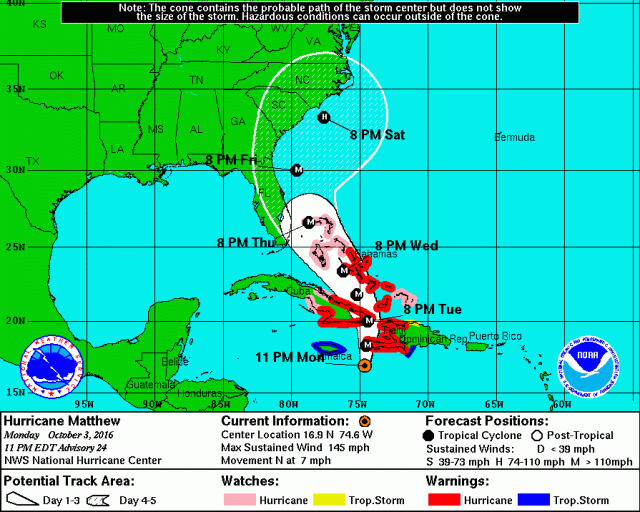
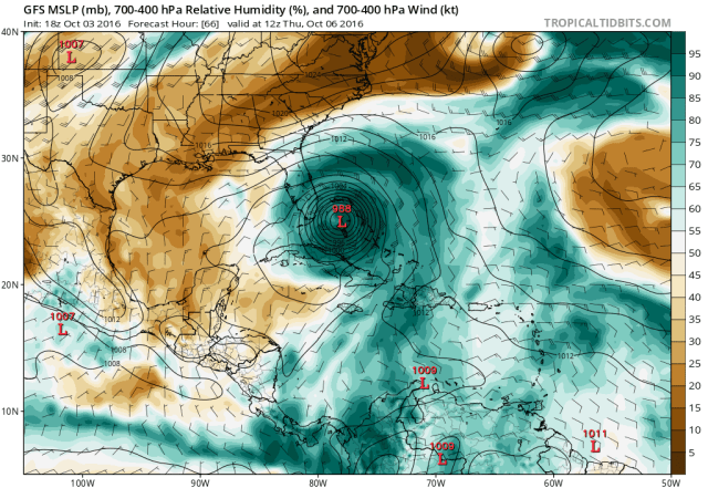
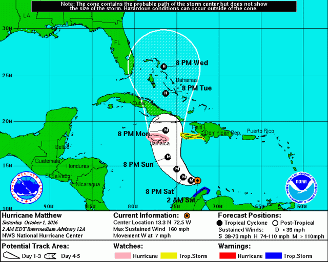
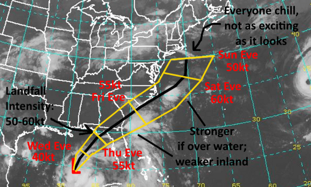
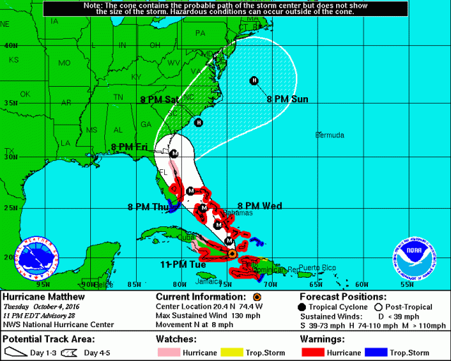
Hurricane Matthew has produced very heavy rainfall resulting in severe flooding, damaging winds, and dangerous storm surge in Haiti and Cuba on Tuesday, and is continuing to affect the islands into Tuesday night. Exact amounts of damage ad fatalities may not be known for at least several days. Matthew will likely officially be a category 3 by the 11PM Tuesday advisory from the National Hurricane Center, down a peg from before it hit Haiti and Cuba but still a dangerous major hurricane. Matthew will move slowly to the north-northwest through the Bahamas through Thursday night and remain a major hurricane. Intensification into at least a category 4 hurricane is possible once Matthew moves farther away from the mountainous terrain of Cuba and Haiti and gets a chance to re-organize. A prolonged period of strong winds, heavy rain, and storm surge is expected across the Bahamas, with conditions not completely improving until Thursday or Friday.

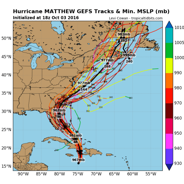
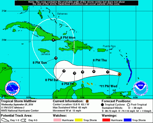
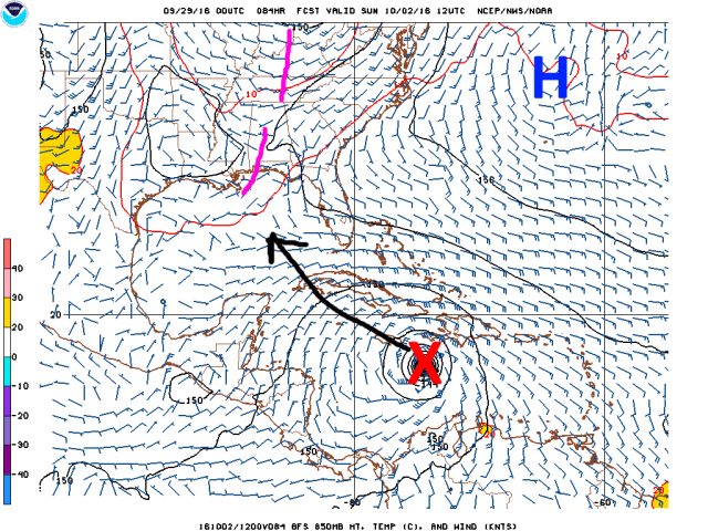
The forecast path of Matthew remains very close for the east coast of Florida, with Matthew expected to be a major hurricane as it makes its closest approach to the Sunshine State Thursday through Friday night. Hurricane watches and warnings along with tropical storm warnings are up for a good portion of Florida. Regardless of whether or not the center makes land fall, storm surge along the coast, heavy rains, and gusty winds are expected, especially over eastern Florida. The possibility still exists that Matthew makes landfall in eastern Florida, in which case a significant storm surge and wind damage would occur. Residents in Florida should continue to closely monitor the progress of Matthew and evacuate if ordered to.

After impacting Florida Matthew is expected to turn northeast and accelerate, passing close to or potentially hitting southeastern Georgia and the Carolinas Friday night through Saturday night. Right now, heavy rain, gusty winds, and dangerous beach conditions are expected in the Carolinas and southeastern Georgia. The odds of a direct impact on North Carolina may be decreasing, while it’s still too close to call for Georgia and South Carolina. Anyone from the Outer Banks points southwest along the coast should continue to closely monitor Matthew and heed the advice of local officials. Some evacuations have either already been ordered or are being planned in parts of the Carolinas. Tropical storm or hurricane watches could be issued fairly soon for portions of the Georgia, South Carolina, and North Carolina coastlines.

North of the Carolinas, it still appears more likely that Matthew moves east or northeast, away from the Mid Atlantic and New England coasts, but at minimum dangerous beach conditions are likely in these areas into early next week. A track farther west that brings rains and stronger winds is still not impossible, so folks from Virginia north through New England need to continue to closely monitor Matthew…however, the odds of a direct hit appear to be decreasing. The areas most likely to potentially see heavy rain and gusty winds are eastern Virginia and the Delmarva Peninsula.

Continue to monitor forecasts from the National Hurricane Center, your local weather service, and heed advice from local emergency management officials when making hurricane related decisions.

Meteorological Discussion:

Many model images used in this post, including the trend loops, can be found at http://www.tropicaltidbits.com

Matthew IR.gif

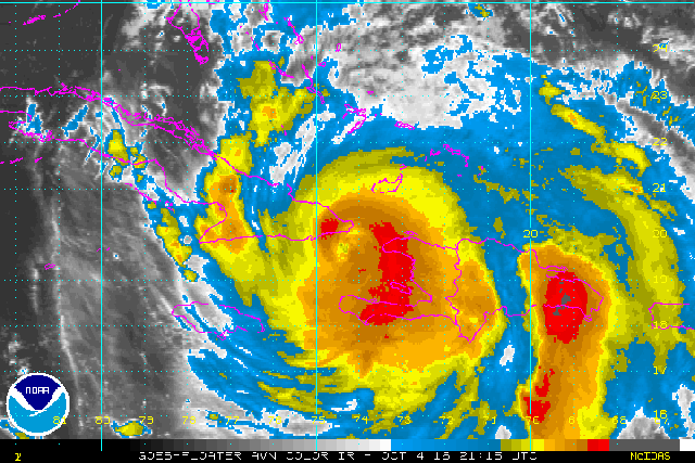
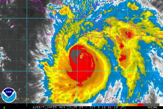
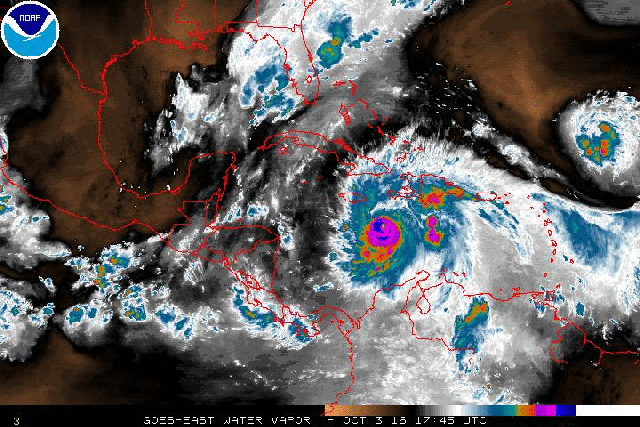
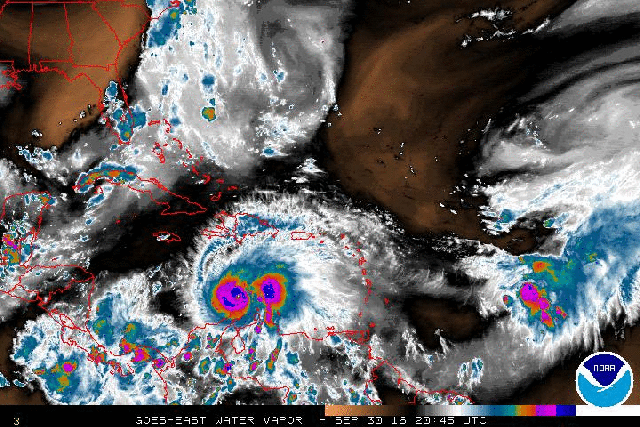
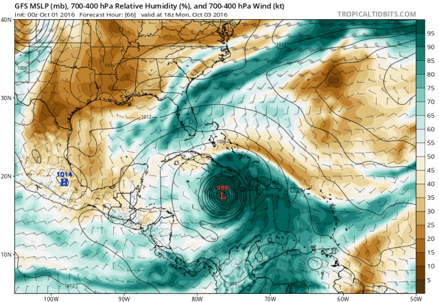
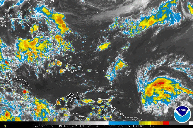
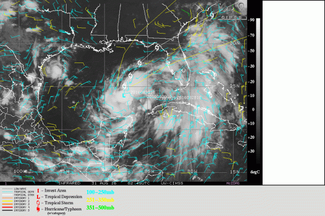
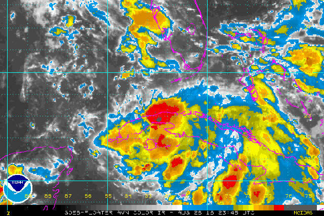
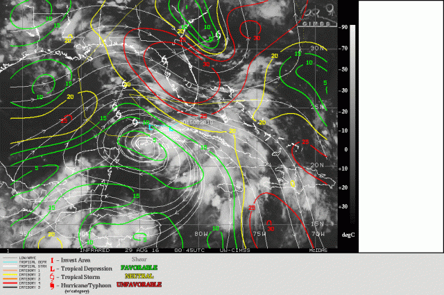
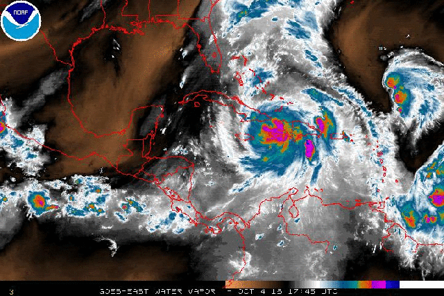
Satellite loops show that land interaction has had some negative impact on Matthew; the eye briefly tried re-appearing between Haiti and Cuba late this afternoon, but has again clouded over as the center moves into the eastern tip of Cuba, which does feature mountainous terrain. The eyewall convection isn’t quite as intense as it has been for the last few days, with cloud top temperatures of -60 to briefly -70C in the more intense convection, as opposed to a ring of -70C or colder cloud tops that was visible Monday evening. There may be some more additional weakening over Cuba tonight, as the eastern end of the island is very mountainous.

Matthew micro.jpg

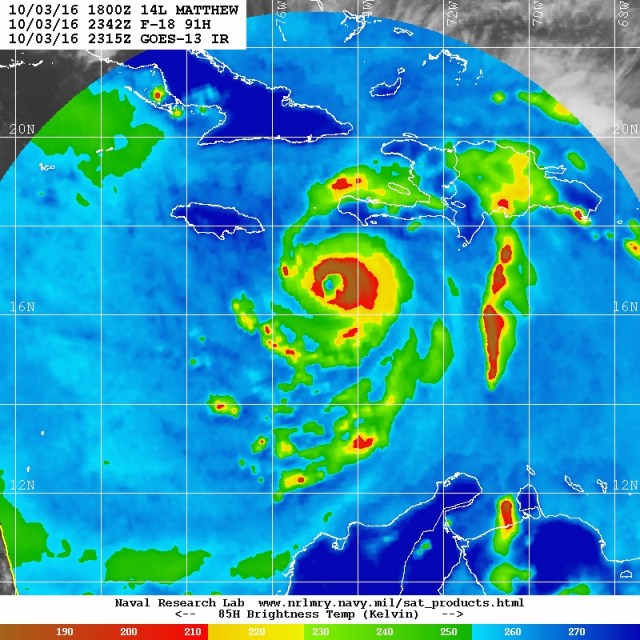
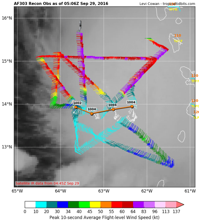
The most recent microwave image, from 7:15PM EDT Tuesday, shows that Matthew still has an intense and well-organized inner core, despite some degradation of appearance on conventional satellite imagery. There is still a closed and intense eyewall surrounding a symmetric eye. Radar from Guantanamo Bay also showed similar organization; unfortunately, high mountains east of the radar site are now blocking the beam, preventing the radar from getting a picture of the inner core.

Matthew recon.png

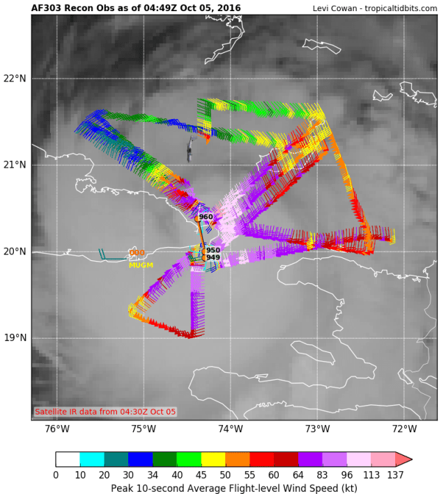
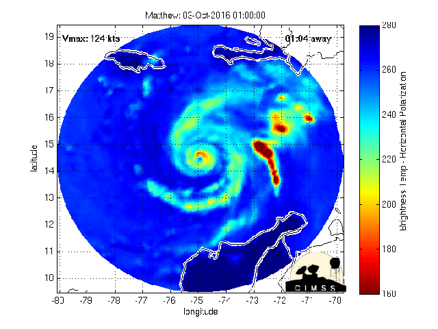
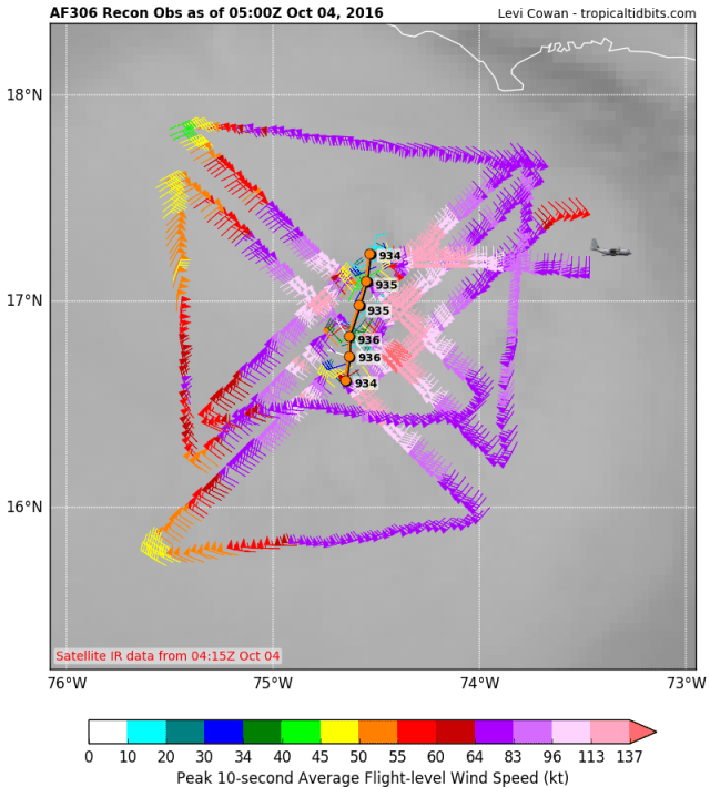
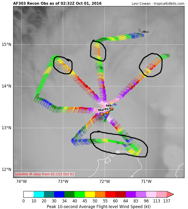
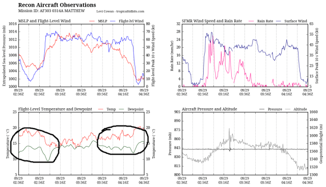
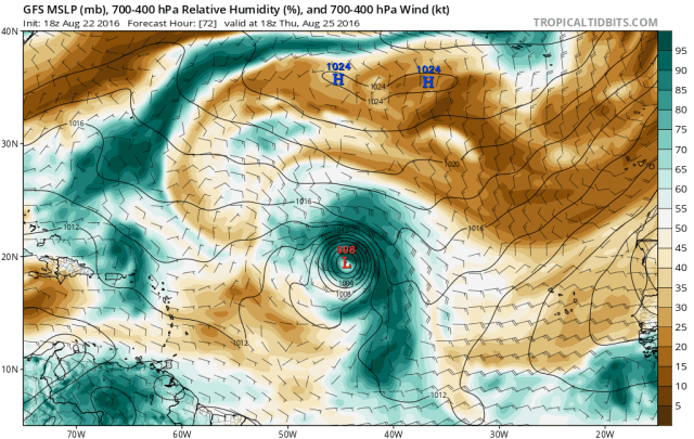
Recon has found that Matthew’s pressure has come up to around 960mb, a good 25mb higher than early Tuesday morning when Matthew his the western tip of Haiti. Also, flight level winds are generally around 115 knots, with reliable SFMR readings of around 110 knots, suggesting that Matthew is in all likelihood no longer a category 4 hurricane. Some further weakening is possible over the next few hours as Matthew’s inner core continues moving over high terrain; regardless, Matthew will likely emerge as a category 3 hurricane north of Cuba later tonight. My guess is winds weaken to 100 or 105 knots before bottoming out later tonight. Matthew still has a large area of hurricane force winds per recon.

matthew-recon-graph

The most recent passes feature flight level winds of almost 120 knots and peak SFMR winds of around 105 knots; this doesn’t support category 4 intensity, but parts of the eyewall are over eastern Cuba, so the plane may not have sampled the strongest winds.

Matthew WV.gif

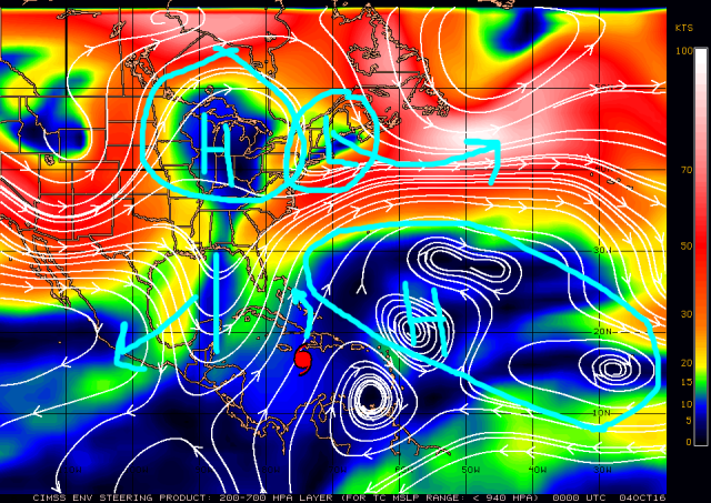
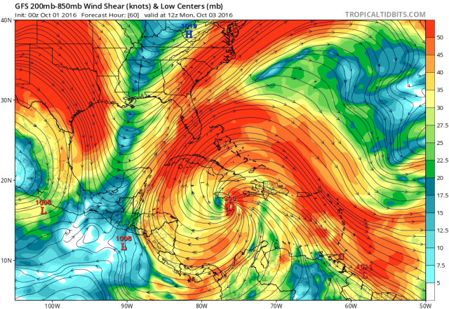
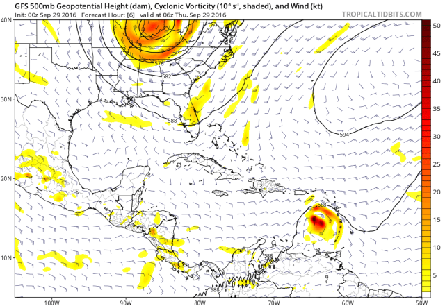
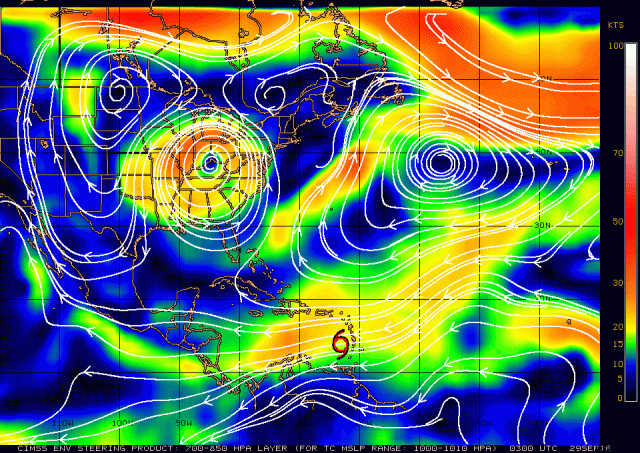
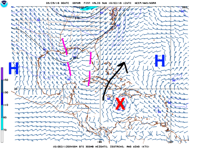
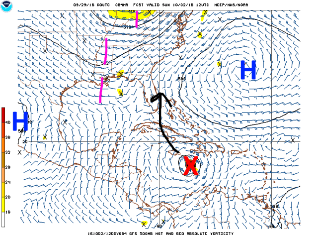
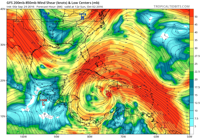
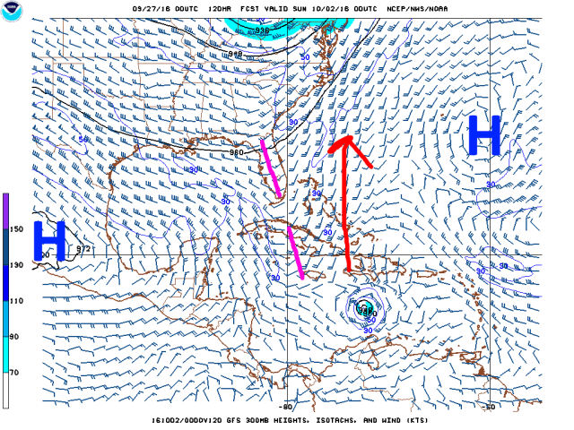
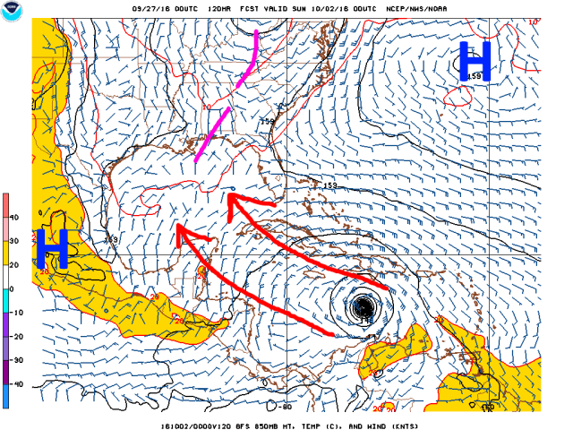
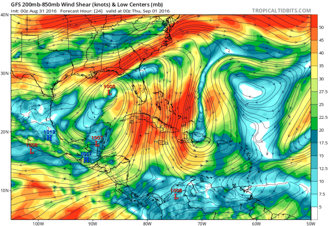
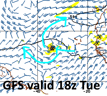
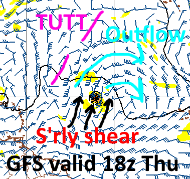
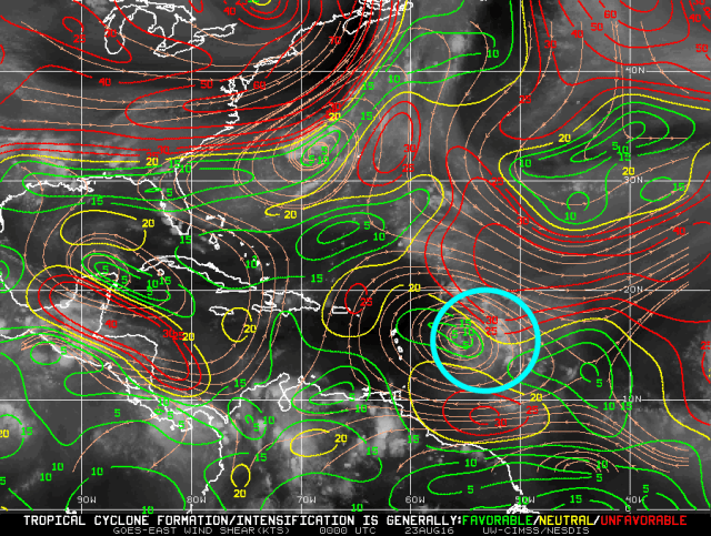
Water vapor imagery continues to show an upper level trough/low to the west of Matthew over the Gulf of Mexico, causing stronger south-southwesterly winds to occur just west and north of Matthew. It appears, based on symmetric outflow and a symmetric CDO, that these south-southwesterly winds aloft aren’t quite making it to Matthew due to the strong upper level anti-cyclone located over the hurricane. These stronger upper level winds are helping to provide for strong outflow north of the storm. The combination of very weak shear and strong outflow is expected to continue in the short term as Matthew begins moving over the Bahamas. There is also little evidence of very dry air in the vicinity of Matthew; the main impediment at the moment is interaction with mountainous terrain.

Matthew SST.png

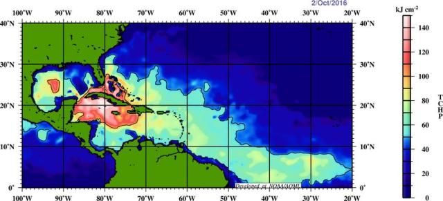
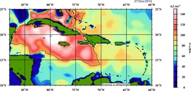
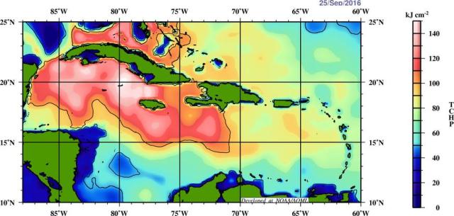
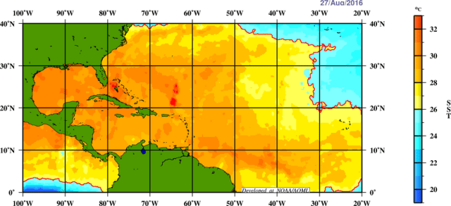
Sea surface temperatures over the Bahamas and off the east coast of Florida ahead of Matthew range from 29-31C, with warm waters extending to a fair depth; this is mid to upper 80s Fahrenheit water. The combination of low shear, a moist atmosphere, strong outflow, and very warm waters suggests Matthew may have a window to become a very powerful hurricane by Thursday or Friday over the Bahamas and possibly very near the Florida coast. We’ll have to see how intact the inner core is once it moves off of Cuba; it appears that it should be fairly intact; if the inner core remains fairly organized, the prospects of intensification back into a category 4 and possibly close to a category 5 hurricane is on the table. An eyewall replacement could occur at some point which may cause intensity fluctuations that are hard to predict very far in advance. Regardless, Matthew will likely be a very strong, fairly large, and dangerous hurricane over the Bahamas and near the Florida coast through the end of the work-week.

matthew-steering-current

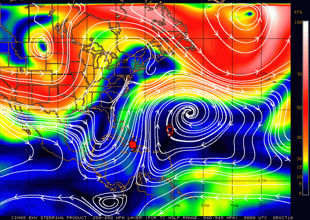
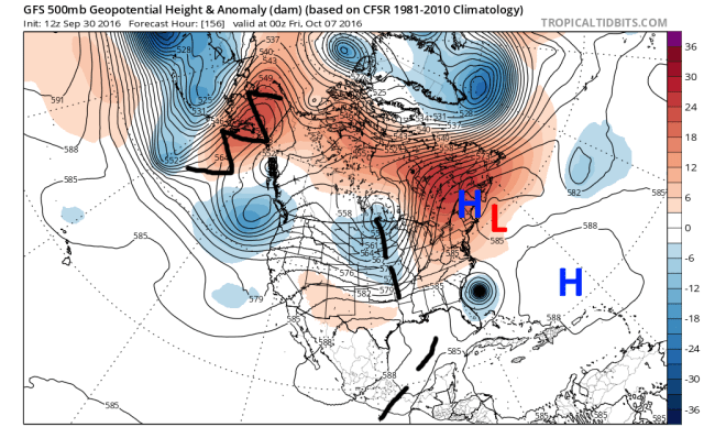
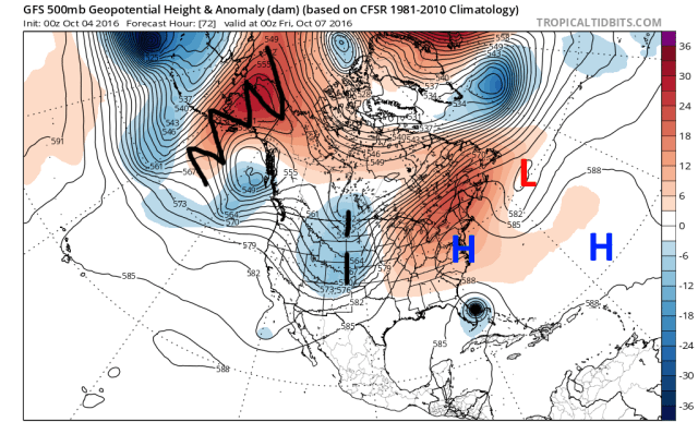
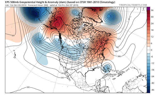
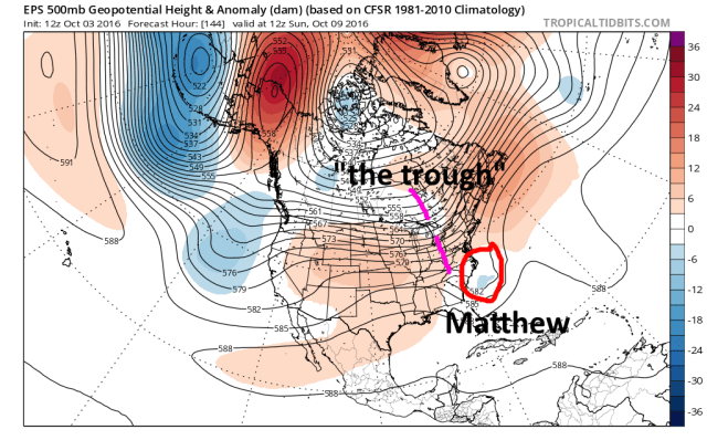
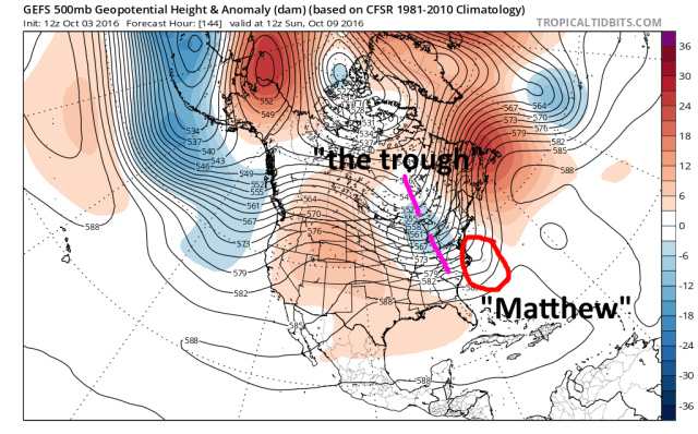
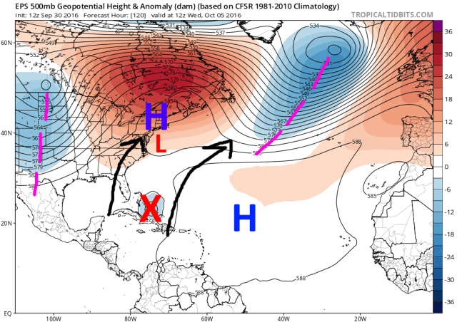
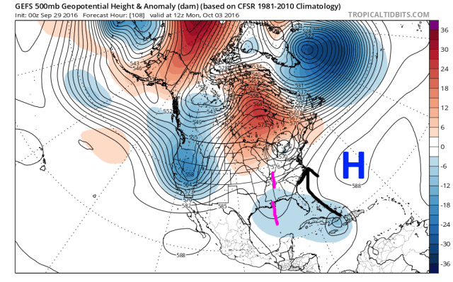
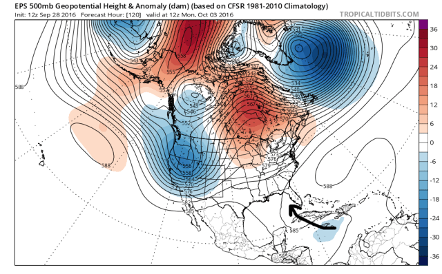
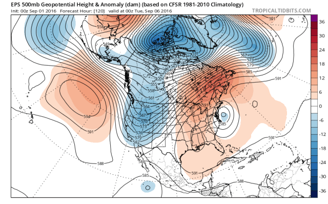
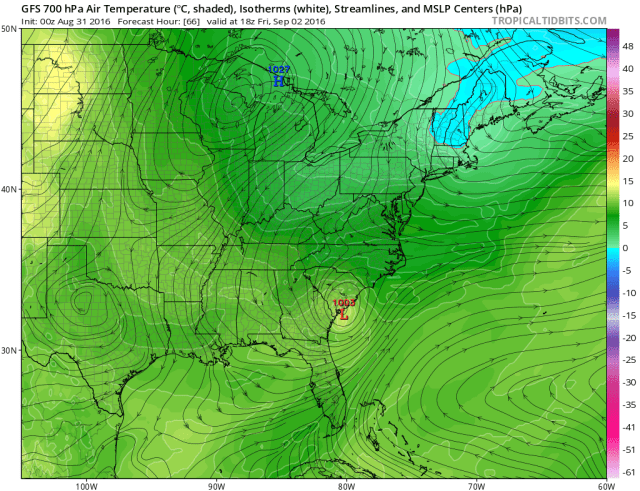
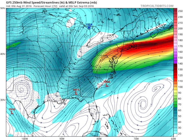
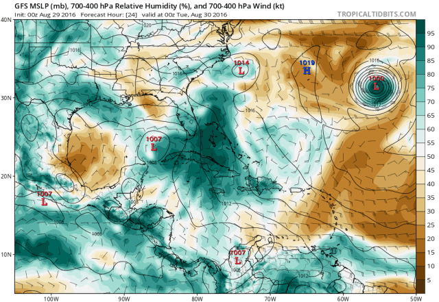
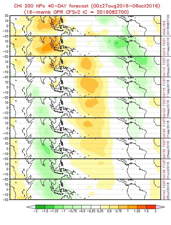
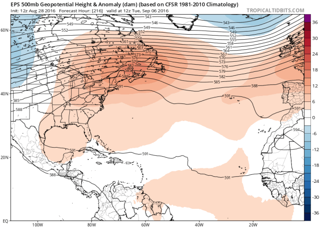
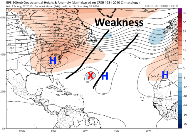
Matthew is currently moving north-northwest through a weakness between ridging over the central Atlantic and over the eastern Great Lakes and New England. This weakness is caused by both the corpse of a cut-off low moving off of the New England coast and an upper level trough over the Gulf of Mexico. As a trough amplifies over the central US, the ridging will strengthen over the Northeast; at the same time, the cut off low will move east and weaken, and the Gulf of Mexico trough will weaken and move west. Matthew isn’t moving particularly fast and will be nudge to the north-northwest over the next couple of days as the ridging builds ahead of the storm.

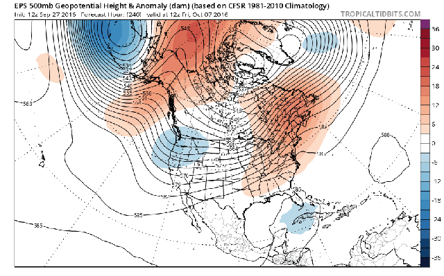
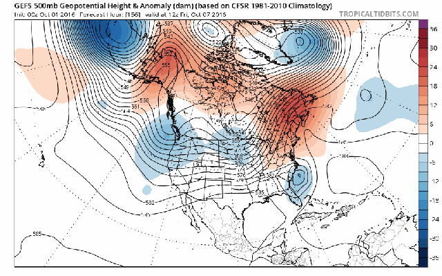
Trends discussed yesterday in the models have continued in the ensembles over the last day in the relatively short term portions of the forecast:

ecmwf-ens_z500a_namer_fh72_trend

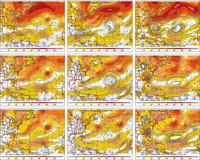
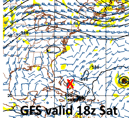
First, the European ensembles. The ensembles have continued the trend to move the cut-off low east quicker, allowing for ridging to build in stronger ahead of Matthew, pushing the storm farther southwest in the near term. This has significant impacts on the threat level to Florida. In addition, there continues to be uncertainty regarding the evolution of shortwaves moving in off of the Pacific and hence the amplitude of the shortwave moving through the Midwest. This run has the shortwave a little farther east at 12z Friday, and also has a somewhat stronger shortwave diving into the west coast; this could result in height rises over the central US, which would kick the first shortwave over the Midwest to the east/northeast quicker, giving it less of an opportunity to eventually potentially pick up Matthew. The EPO ridge over Alaska has actually come in a bit stronger, but the evolution of the shortwaves under that ridge remains uncertain, with models jumped around with them quite a bit.

gfs-ens_z500a_namer_fh66_trend.gif

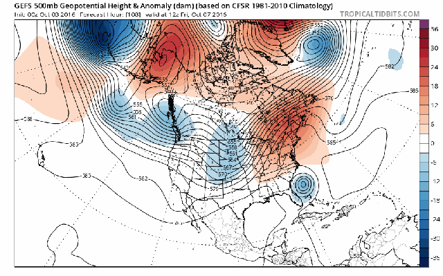
The GFS ensembles also show the weakness in ridging closing a little bit quicker, suggesting Matthew may turn a little more to the left in the short term; there is still inconsistency in the shortwave in the Midwest and its impact on the downstream ridging over the east. In general, the last few runs bring in the next shortwave a little bit quicker, causing the Midwest shortwave to be a little bit flatter.

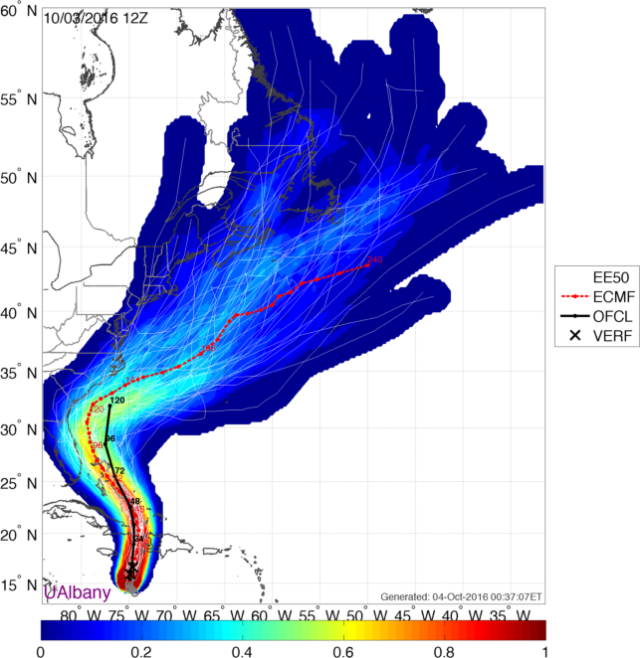
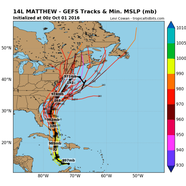
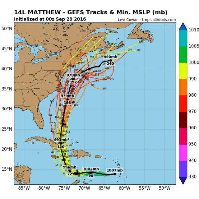
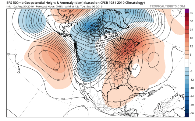
Here is a look at the recent track forecasts from the GFS and European ensemble members:

Matthew GEFS tracks.png

Matthew EPS tracks.png

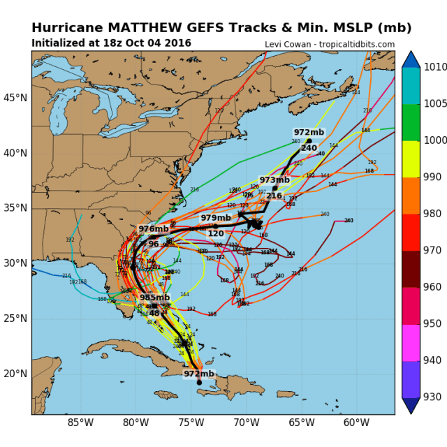
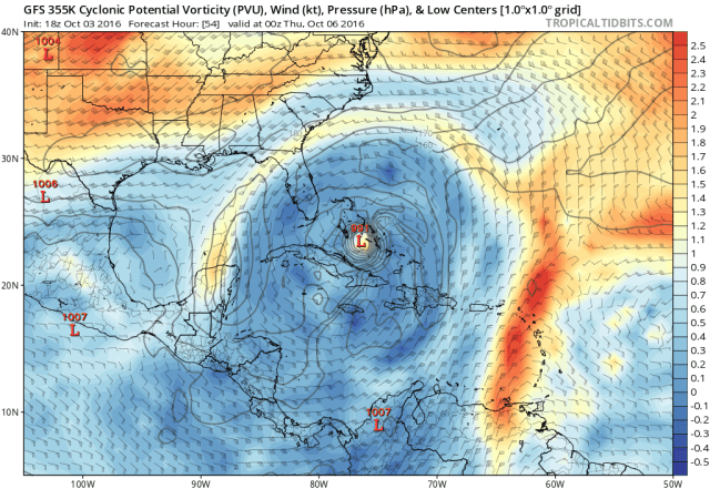
In general, both sets of ensembles have nudged west a little bit closer to Florida since yesterday; more than half of the European ensemble members bring the center within 50 miles of the Florida coast, and it appears a good 30% actually have a true landfall. The GFS ensembles may be a tough farther east, but in general also imply a very close call for Florida.

The bigger change may be from the Carolinas points north; yesterday, the GFS ensembles had many members on the Carolina coastline, even a few which went just inland. From there, many GFS ensembles moved just off the Mid Atlantic coast, with a few hooking into southern New England. The GFS ensembles were in general farther south/east than the GFS ensembles, but did still have some members that threatened the Carolinas and a few stragglers that threatened the Mid Atlantic and New England. That is not the case today…many ensemble members do buzz the Georgia and South Carolina coastlines quite closely, but both suites now show Matthew moving more east/northeast, keeping it farther away from North Carolina and not even sniffing the Mid Atlantic.

matthew-gefs-114

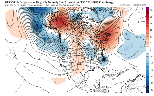
The ensembles have trended slower with Matthew and have trended towards more ridging over the central US, causing the trough to be less amplified. This makes it less likely that Matthew gets captured by the trough and directly impacts the Mid Atlantic and New England. I was skeptical of that solution yesterday and am not any more enthused about it today.

A few ensemble members and operational model runs show the trough missing Matthew so far to the north that it remains trapped off the Southeast coast while ridging builds back in over the eastern US. It is too far out to speculate on whether or not this new solution holds any validity, or on how strong Matthew would or would not be if it ended up sitting off the coast for a more extended period of time.

Summary:

-Matthew will move through the Bahamas as a category 3 or 4 hurricane over the next couple of days. Significant impacts will accompany it.

-The threat to Florida appears to have increased a little bit more due to more ridging expected ahead of a Matthew, and the slower motion the Euro suite has been insisting on appearing to be more realistic.

-There is still some threat to the Carolinas, but the slower storm and less amplified trough suggest it may get kicked more due east, meaning it may move farther away from the coast that angles to the northeast with time.

-The threat of a direct hit north of North Carolina is extremely low, but I suppose the possibility can’t be ruled out. Indirect impacts such as heavy rain are possible, mainly in eastern Virginia and the Delmarva. Dangerous beach conditions will occur along the entire east coast.

-Climatology suggests that Matthew being completely missed by the trough and then completing an anti-cyclonic loop off the Southeast coast and near the Bahamas isn’t a likely solution, but several pieces of guidance are now showing it…Matthew is slowing down its forecast northward movement over the next few days, and the trough has continued to trend less amplified, so we will watch that possibility.

Posted in Uncategorized | Leave a comment

10/3/16: Powerful Matthew Heading Towards Haiti & Cuba; Will Pass Through Bahamas and Threaten Southeast & Florida

General Discussion:

matthew-nhc

Hurricane Matthew has remained a category 4 hurricane almost non-stop since late Friday night, and is now moving north towards the Windward Passage. Matthew will slowly move between Haiti and Cuba through Tuesday, possibly making a landfall on the western tip of Haiti or the eastern tip of Cuba. Matthew is becoming a larger storm and is slow moving, meaning the mountainous terrain in eastern Cuba, Haiti, and the Dominican Republic will see locally over 30” of rain, resulting in potentially catastrophic flash flooding. Significant storm surge is also likely on portions of the Haitian coastline, and damaging winds are also likely in far eastern Cuba and in parts of Haiti. A very high death toll is likely in Haiti.

Matthew will emerge over the southern Bahamas on Wednesday and will slowly move north-northwest across much of the island chain. Matthew’s interaction with the high terrain of Haiti and Cuba may briefly weaken it to a category 2 or borderline category 3 hurricane, however the environment will be favorable for re-intensification, and it’s likely that Matthew remains a major hurricane as it moves over the Bahamas, or re-intensifies into a major hurricane if it gets weakened below category 3 status by the interaction with eastern Cuba and Haiti. Matthew’s slow movement will cause a prolonged period of strong/damaging winds, heavy rain, and dangerous storm surge across many of the Bahama Islands. Conditions in the Turks and Caicos and southern Bahamas should begin to improve by Thursday, with the northern Bahamas possibly seeing adverse weather through Friday.

Matthew’s forecast track has shifted westward gradually over the last couple of days and now is just off of the east coast of Florida. Matthew is expected to be a large and strong hurricane through the end of the week, and strong winds, heavy rain, and coastal flooding look increasingly likely over parts of the Florida peninsula. A direct hit on the east coast of Florida is still well within the realm of possibilities, which would increase the odds of more significant wind damage and storm surge in parts of Florida.

Matthew is expected to slowly continue moving north into the weekend and will either come very close to or pass over the Carolina coastline. It is looking increasingly likely that at a minimum, gusty winds, heavy rains and dangerous surf will affect the coast from Georgia up to the Outer Banks…with a direct landfall somewhere in the Carolinas still being within the realm of plausible solutions.

Exact impacts north of the Carolinas are much more uncertain, however the entire East Coast should closely monitor the progress of Matthew this week.

Always check forecasts for the National Hurricane Center, your local Weather Service, and heed advice of emergency management officials when making hurricane related decisions.

Meteorological Discussion:

matthew-ir

The inner core of Hurricane Matthew has fluctuated in form and intensity over the last 3 days, and is still doing so this evening. After a few false starts on Saturday and Sunday, it appears that an eyewall replacement cycle may have finally/quickly occurred Monday afternoon/evening. Recently, cold cloud tops have expanded markedly in the eyewall, although the eyewall may still be open on the southwest or south side, possibly explaining why the eye has clouded over this evening. If the eyewall can close off, there is still a short window for additional intensification before interaction with the mountainous western tip of Haiti…as it stands now, Matthew is an extremely dangerous category 4 hurricane.

matthew-micro

Microwave imagery from Monday evening shows that the inner core of Matthew is larger than it was when it became a category 5 hurricane for a brief time Friday night, however the eyewall is producing very intense convection and is almost completely closed off. A little bit of dry air has been trying to intrude into Matthew’s inner core at times over the last couple of days, which may be why the eyewall has a bit of a soft spot…however, if Matthew can close off the eyewall completely, the very intense convection in the eyewall suggests we may see one more run towards a category 5 before impacting the western tip of Haiti Tuesday morning. This isn’t certain but is possible…either way, Haiti is looking at a dire situation and unfortunately a very high death toll in all likelihood.

Matthew micro loop.gif

A loop of microwave images from Monday afternoon and evening does suggest that an eyewall replacement cycle may have quickly (and finally) occurred; there are signs of an outer eyewall forming late Sunday night, with a bit of a “moat” surrounding the inner eyewall. Although Matthew never had the true “concentric” or “double” eyewall look associated with eyewall replacement cycles, the outer eyewall appeared to quickly contract while the inner eyewall quickly weakened. Recently, the eyewall has really intensified and is close to closing off again, a sign that Matthew may still have room to intensify before hitting Haiti.

Matthew recon.png

Remember when Matthew was a category 5 hurricane, and winds quickly went from tropical storm force to 135 knots within a few miles of the center? Recon shows that Matthew is now much larger, another sign that an ERC may be occurring/about to finish. There isn’t really a double wind maximum with Matthew, so again we may be close to the inner core closing off and possibly intensifying tonight. Whether or not the inner core intensifies means little to Haiti and eastern Cuba, as devastating impacts are likely regardless…especially in Haiti. The larger core will increase storm surge in Haiti, and also increase the amount of land that sees damaging winds.

Matthew WV.gif

Water vapor loops continue to show an upper level trough to the northwest of Matthew over the Gulf of Mexico, however the trough has weakened/shifted west a bit over the last few days. The southwesterly shear imparted by this trough has weakened over Matthew, and Matthew is moving parallel to the shear now. Matthew has a very symmetric outflow, and it appears that the upper level anti-cyclone is co-located almost perfectly with the hurricane…which isn’t particularly surprising given how long the storm has been producing deep convection. The combination of the upper level trough weakening/backing west a bit and the upper level anti-cyclone becoming more co-located with Matthew has allowed shear to drop to almost 0 over the hurricane, with the trough to the northwest and upper low to the northeast of Matthew helping to provide for strong outflow. With Matthew moving over very high heat content waters south of Haiti, the potential for intensification up until landfall or approach on the western tip of Haiti is certainly there if the eyewall can completely close off.

The western tip of Haiti and eastern Cuba have high terrain, which will likely weaken Matthew some…however with Matthew intensifying right up to land interaction, and a relatively minimal amount of land interaction, Matthew may emerge over the southern Bahamas as a strong category 2 or category 3 hurricane.

Matthew steer current.png

The steering currents map for Matthew Monday evening shows several features affecting the short and medium term motion of Matthew; currently, Matthew is being steering to the north or even slightly east of due north by ridging to its east. Mathew will approach the western edge of this ridging and get nudged west over the Bahamas. At the same time, there is a ridge building over the Great Lakes that will move over the Northeast as an upper low currently over New England moves off to the east. As the ridging builds into the Northeast, it may connect with the Atlantic ridging and block Matthew’s escape route out to sea. A trough moving in from the western US may also either phase with Matthew and pull it north-northwest into the coast, or kick it northeast, depending on both the orientation of the trough and the position of Matthew later this week.

matthew-gfs-vort-54

When Matthew emerges over the open Atlantic over the Bahamas on Wednesday, it will remain in a very favorable upper level environment…with a very large anti-cyclone over the storm keeping any upper lows and troughs away from the hurricane, and providing for strong outflow. There also doesn’t appear to be any very dry air in the immediate path of Matthew over the next few days:

matthew-gfs-rh-66

In addition, oceanic heat content remains very high over much of the Bahamas, with near 30C/mid to upper 80F sea surface temperatures extending to significant depths. Heat potential doesn’t become a limiting factor until you get close to the Carolinas:

matthew-tchp

It’s always tough to tell how tropical cyclones will handle land, especially land with mountains. Matthew will traverse a very short distance over land, with large portions of the hurricane remaining over very warm waters at all times…however, the land is mountainous, which normally has a significant impact on the inner core of tropical cyclones. I suspect that given the pros and cons and Matthew’s apparent intensification up to land interaction that Matthew will remain a major hurricane as it emerges into the open Atlantic. If Matthew jogs over more land it may briefly get knocked back to a category 2 before the overwhelmingly favorable conditions over the Bahamas allow for re-intensification. Matthew will have a full 2-3 days in this very favorable environment before shear, dry air, and lower heat content likely weaken the hurricane as it gets closer to the Southeast Coast, so barring an earlier landfall into Florida it is very possible that Matthew re-attains category 4 intensity once again over the Bahamas. Depending on how quickly the inner core re-organizes after passing near/over mountainous terrain, one more run at a category 5 isn’t impossible.

Matthew GFS old 500.png

When I last posted on Friday, I noted that the majority of guidance left Matthew a path to escape east without directly impacting the United States, and that at that time I was leaning towards that solution. But, as any good meteorologist would, I covered my ass and discussed what may happen to allow for a farther west track. Meteorology is an imperfect science, and it is important to diagnose what the “key players” are in a forecast and keep an eye out for any change in those players. I’m sure some more overly aware readers are already pointing out that the above image is an old run of the GFS model. This run of the from Friday afternoon, like most other guidance at the time, had Matthew close to the SE US but ultimately kept the storm off the coast and eventually took it out to sea. At the time, the models had a few features that were slightly “off” for a US East Coast hurricane hit:

-The cut off slow slowly moving off of the New England coast combined with a weak trough over the Gulf of Mexico to leave a weakness between ridging over the Atlantic and ridging over the Northeast, leaving Matthew a path to escape out to sea.

-The flow into the western US was progressive, with shortwave trough after shortwave trough crashing into the coast. Troughs were having trouble dipping far enough south in the models to capture Matthew, and instead either missed the hurricane to the north altogether or kicked it to the northeast, away from land.

Matthew GFS 500 72.png

The more recent model runs have changed some of the aforementioned players somewhat, and it has an impact on Matthew’s future track:

-The upper low pulls away from the Northeast faster, allowing the weakness in ridging to close, leaving Matthew behind off the Southeast coast.

-Matthew is slower than the above GFS run, more in line with what the Euro has consistently shown, which gives more time for the weakness in the ridging to close.

-The ridging over Alaska is somewhat stronger, allowing for a somewhat more amplified/slower trough coming out of the west, which may have implications down the road on potential impacts to the Mid Atlantic and/or New England.

Matthew EPS 96 500.png

The GFS is not alone in showing a solution more conducive to either a close shave or a direct Matthew in on Florida or the Southeast coast; this afternoon’s run of the European ensemble also shows the weakness in ridging pulling away, with ridging building ahead of Matthew and preventing a quick escape out to sea. There is however considerable spread in the European ensembles on the speed/amplitude of the trough ejecting out of the western US. This trend on the European ensembles can be seen since the day 10 forecast valid Friday morning, on this fantastic trend loop from the Tropical Tidbits website:

ecmwf-ens_z500a_namer_fh96_trend

Note how over the last few days’ worth of runs, the Alaskan ridging has trended stronger, the trough, despite ensemble spread resulting in the mean being a bit smoother, becoming deeper as it ejects in the central US, and the ridging ahead of Matthew has also trended stronger. There has also been a trend to higher heights over Greenland, perhaps also contributing to a more amplified pattern over the US. Despite the insane ensemble spread early on, it is important to note that the Euro ensemble’s general slower motion with Matthew than the GFS suite was more correct.

gfs-ens_z500a_namer_fh90_trend

Speaking of the GFS suite, the GFS ensembles have also shown a consistent trend to amplify the trough coming out of the west due to a more intense Alaskan ridge/-EPO, to build ridging ahead of Matthew more aggressively, and to slow the hurricane down over the last 3 days’ worth of runs.

This prolonged and consistent trend for a slower and more amplified central US trough and stronger ridging along the East Coast ahead of Matthew, due to the hurricane moving slower than some models expected and due to the cut off low moving away quicker, is concerning and is likely legitimate, given these trends have been consistent for several runs on almost every model.

The main question now is will the trends stop, reverse, or continue? Given the cut off low moving off the Northeast coast will only move so fast due to the very nature of cut off lows, I do think there’s a limit to how strong ridging ahead of Matthew can get. I think a direct landfall on the east coast of Florida is possible, with the hurricane then bending NE and possibly also directly hitting the Carolinas and possibly getting close to Georgia. I do not foresee a scenario in which Matthew plows deep into Florida as being plausible, due to the cut off low’s weakness in the ridging likely allowing for enough of a northward motion to prevent that…however, significant impacts from a major hurricane are becoming increasingly likely in eastern Florida. The most recent runs of the ensembles all agree on a very close shave for the eastern Florida coast, and it’s important to note that recent model trends in the “key players” haven’t stopped, which again means that a direct hit is at least possible:

Matthew GEFS tracks.png

matthew-eps-tracks

As we head towards the weekend, the trough coming out of the western US will approach the eastern US, where Matthew will be waiting to interact with it. There are three possible solutions here:

  • Matthew is south of the base of the trough and gets kicked to the northeast, away from land, as the trough moves in
  • Matthew is not south of the base of the trough, but the trough is neutrally or positively tilted, and the cyclone gets accelerated to the north/northeast and passes very close to the Mid Atlantic coast and possibly clips eastern New England
  • Matthew is not south of the base of the trough, the trough is negatively tilted, and the cyclone gets captured by the trough while accelerating north/northwest and deepening. This is a worst case scenario for this storm for the Mid Atlantic and New England.

The million dollar question at this time of course is, which solution is more likely?

Matthew EPS 144.png

If you believe the European ensembles, Matthew is slow enough and the trough is progressive enough that Matthew is still south of the trough base when it moves east, resulting in a kick northeast and away from land. As you can see from the above probability map from the Monday afternoon Euro ensembles, most members do NOT hook Matthew back towards the Mid Atlantic or New England after the close call for the Southeast. It is worth noting that with a stronger –EPO and perhaps a –NAO that the pattern may still trend more amplified, this is 6 days away.

matthew-gefs-144

The GFS ensembles are a little bit quicker with Matthew than the European ensembles, and also are more amplified with the trough. This gives Matthew a better shot at possibly being captured by the trough. With that said, AT THIS TIME, most GFS ensemble members do not capture Matthew and kick it northeast and away from land as the trough approaches.

“Slower” has been the correct solution for Matthew so far, and the GFS ensembles, which are faster, still largely fail to capture Matthew. Given this, I’m leaning towards Matthew moving northeast and away from the coast after impacting the Carolinas, but it is less than a certain call.

Factors to watch for the Mid Atlantic:

  • Does –EPO ridging or –NAO ridging intensify enough to amplify the trough more
  • Does ridging ahead of Matthew weaken just enough for a quicker track northeast, giving the trough better odds at capturing it.

matthew-gfs-250-144

Regardless of whether or not Matthew directly impacts the Mid Atlantic or New England, a jet streak and cold front ahead of the trough will provide for strong lift as moisture from Matthew gets drawn northward ahead of the front, potentially resulting in heavy rain over the Mid Atlantic and New England. Some drought stricken areas could use the rain.

Summary:

-Matthew will produce devastating flooding in the Hispaniola and damaging winds in portions of Haiti. A very high death toll is sadly quite possible in Haiti. Significant impacts will also be felt in eastern Cuba.

-Matthew will slowly track over much of the Bahamas as what will likely be a major hurricane.

-The chances for significant impacts to eastern Florida have increased, and a landfall is possible as a major hurricane.

-The chances for significant impacts to coastal Georgia, North Carolina, and South Carolina have increased, and a landfall as a hurricane is possible in the Carolinas.

-A direct impact on the Mid Atlantic or New England still seems unlikely, but trends in Matthew’s speed and the amplitude of the incoming shortwave trough this weekend need to be watched closely.

Posted in Uncategorized | Leave a comment

10/1/16: Matthew Becomes the First Atlantic Category Five in Nine Years; Significant Threat to Some Land

matthew-nhc

General Discussion:

Hurricane Matthew has intensified much faster than anticipated over the last two days, and as of Friday evening became a category 5 hurricane. This is the first category 5 hurricane in the Atlantic Basin since Hurricane Felix in 2007. Matthew has begun slowing and will make the much anticipated northward turn Saturday night into Sunday. This turn will take Matthew over or near Jamaica Sunday night into Monday.

Fluctuations in intensity are likely over the weekend, but Matthew will be at least a category 3 hurricane as it makes its closest approach to Jamaica; the potentially for life threatening flash flooding/mudslides, storm surge flooding, and significant wind damage is increasing on Jamaica. Jamaica may cause Matthew to lose some intensity, but Matthew is still expected to be at least a category 3 hurricane Monday night into Tuesday as it moves into eastern Cuba. Again, a significant risk for life threatening inland flooding, storm surge flooding, and destructive wind damage will accompany Matthew over eastern Cuba. Haiti may also see gusty winds and very dangerous inland flooding; a slight jog east in Matthew’s track could bring devastating hurricane conditions to Haiti as well.

After moving over Cuba, Matthew will move north-northwest into the Bahamas on Tuesday and slowly move north across the island chain. Cuba’s higher terrain will weaken Matthew, but a favorable environment for re-intensification looks to exist over the Bahamas, so Matthew will certainly be a hurricane and potentially re-intensify into a major hurricane as it passes over the Bahamas through mid-week.

The track after hitting the Bahamas and future threat to land…including the US East Coast from Florida to New England is highly uncertain. It is possible that Matthew even drifts near or over the Bahamas for a few days. Interests in a large swath of real-estate along the East Coast need to continue to monitor the progress of Matthew.

Please check forecasts from the National Hurricane Center, your local Weather Service office, and heed advice of Emergency Management officials when making hurricane-related decisions.

Meteorological Discussion:

Matthew IR.gif

From a tropical storm with a nearly exposed low level circulation Wednesday morning to a category 5 hurricane Friday evening; Matthew’s transformation in the face of some weak to moderate shear and perhaps a little bit of dry air in the general vicinity of the hurricane has been nothing short of impressive. Friday afternoon saw a small eye emerge, with the eye warming to warmer than 0C with a solid ring of very cold cloud tops surrounding it by Friday evening; this was all indicative of a rapidly intensifying hurricane that did in fact max out the Saffir-Simpson scale. This intensification was completely unexpected to me when I last posted Wednesday evening; I thought that some shear and dry air would at least slow inner core development/organization through Friday, with potentially rapid intensification at some point over the weekend. Sometimes in sheared tropical cyclones, convection firing and rotating up-shear of the center can offset wind shear and allow for intensification. This occurred here, and an otherwise favorable thermodynamic environment for persistent and very deep convection allowed Matthew to go “all the way.”

matthew-recon

Unfortunately, there aren’t any recent microwave images as of this writing to further diagnose the current condition of Matthew; however, there is recon. Usually, these very strong tropical cyclones with tight inner cores are living on borrowed time; it’s inevitable that a larger outer eyewall will eventually form and choke off the much smaller and more intense inner eyewall. This usually results in the system seeing its maximum wind speeds decrease, its pressure increase, but its radius of max winds expands; this is commonly known as an eyewall replacement cycle (ERC). Data from the most recon flight into Matthew is beginning to indicate a secondary wind maximum well away from the very tight inner core. Although this isn’t yet an outer/secondary eyewall, and the inner core is still very much alive and well, this signals that an ERC will probably occur within the next 12-24 hours…or by Saturday night.

Although it’s possible that Matthew intensifies a bit further before the ERC begins, signs Friday evening are pointing to the intensification leveling off; the eye has begun cooling on IR satellite imagery, and the pressure drop during the last recon mission started to slow. My guess is that Matthew sits at borderline cat 4/5 status through Saturday, before weakening to borderline cat 3 or 4 status Saturday night into Sunday as an eyewall replacement happens.

Matthew WV.gif

Water vapor imagery still shows some pros and some cons to the environment around Matthew—yes, obviously Matthew maximized the positives which offset and relatively minor negatives. There is still a large scale southwesterly flow aloft to the southeast of a trough over the Gulf of Mexico, with an upper low embedded within that trough well north-northwest of Matthew. This has allegedly imparted 10-20 knots of southwesterly shear on Matthew over the last couple of days, and will continue to do so; however, Matthew’s organized and robust inner core has fended off this weak to moderate shear. There is also some dry air ahead of Matthew…not a ton, but it’s still there, and if Matthew undergoes an eyewall replacement cycle it may become a little more susceptible to this dry air and shear. Also of note is the overall very divergence upper level flow and strong outflow over Matthew, which likely combined with the very warm water temperatures to allow Matthew to generate significant enough convection to essentially fight off any southwesterly shear. Obviously, inflow off of South America is not drawing enough dry air into Matthew to negatively impact the storm at this point.

gfs_pv355K_watl_fh0-84.gif

The intensity forecast for Sunday and Monday…which is critical to Jamaica, eastern Cuba and Haiti…is not quite straight forward. As I mentioned above, it is highly likely that an eyewall replacement cycle occurs by Saturday night and causes weakening. Normally, eyewall replacement cycles have a hard time completing and allowing the cyclone to return to its previous intensity if shear, dry air, or land interaction interfere with the cyclone. If conditions are highly favorable, sometimes an ERC can complete after 24-36 hours.

The above loop shows the GFS forecast potential vorticity on the 355k surface; basically, it shows where upper level troughs/lows/TUTTs are, because those features are denoted by higher vorticity near the tropopause. The model correctly identifies a PV streamer just NW of Matthew in the early hours of the run, suggestive of a somewhat stronger SW flow aloft near the hurricane right now. Although the hurricane doesn’t show it, there is still weak to moderate SWrly shear affecting it. The model then fractures this PV streamer and/or pushes it away as strong convection and latent heat release with Matthew causes heights to rise over the hurricane, which causes anti-cyclonic/negative vorticity advection around the hurricane, literally pushing away the higher vorticity upper level troughs. This lessens the shear by Sunday and Monday, potentially leaving an environment which could allow for some re-intensification after the ERC.

matthew-gfs-shear-60

The result of all of this on the GFS is an essentially perfect upper level environment for intensification by Sunday and Monday as Matthew churns towards Jamaica. Whether this will come to fruition is unknown, but the GFS and to an extent the Euro have been extremely insistent on the weak to moderate shear currently affecting the cyclone weakening over the weekend…that’s why I initially expected the most substantial strengthening to occur on Saturday-Sunday. Note the diverging upper level winds away from Matthew, with Matthew perhaps being near the right-entrance quadrant of a weak jet streak, which could provide for a very robust poleward outflow channel. In addition, even if some southwest flow aloft persists in the region, Matthew will turn from the WSW track it is on now to the NNW over the next couple of days, meaning the effective shear on the cyclone will decrease. This all suggests the potential for Matthew to continue to produce very deep and persistent convection as it moves over extremely warm waters over the northern Caribbean.

matthew-gfs-rh-66

The other factor to Matthew’s intensity forecast will be dry air; there is dry air northwest of Matthew, which the GFS did properly initialize with, and it will be interesting to see if the ERC can allow the storm to become more susceptible to dry air than it has been thus far. The GFS has the system mixing out any dry air by Sunday, but enough of a dry air intrusion during the ERC may make it hard for it to complete before it starts running into mountainous terrain.

My guess…based on an eyewall replacement happening Saturday-Saturday night, but the environment improving and possibly allowing it to complete just as it approaches Jamaica…is that Matthew will be a category 4 when it hits Jamaica. Can something I don’t foresee happen and cause that guess to be off by a category? Definitely. Does that make a difference? Not really, because this looks like an extremely dangerous situation for Jamaica either way. How Matthew interacts with Jamaica will help determine its intensity when it plows into eastern Cuba Monday night into early Tuesday, but it will in all likelihood be at least a category 3 when it hits eastern Cuba. Depending on if Jamaica can slow down Matthew at all, the very warm waters and seemingly very favorable environment could certainly allow for a category 4+ hit on eastern Cuba. It is still worth noting that Haiti will be on the right (strong) side of a quite possibly major hurricane, and a modest jog right would have extreme impacts on Haiti and the Dominican Republic.

Matthew EPS 120.png

Matthew will likely emerge as a category 2 hurricane in the Bahamas…where it goes from here is highly uncertain, and has impacts on a lot of people. We know the Bahamas will be affected…and it’s possible the hurricane moves slowly over the island chain while re-intensifying, causing significant issues in the Bahamas. After that, possible US or even Bermuda impacts are still unknown.

The key features in this forecast are all visible on the above map from the Friday afternoon run of the European ensembles. The big features are a trough moving east out of the western US, ridges over the central Atlantic and also over the Northeast, and a cut-off low slowly moving off of the East Coast. Without the upper low off the coast ahead of Matthew, the ridging doesn’t have a weakness, and the hurricane is forced to go northwest towards the Southeast coast. However, the upper low is there, which causes a weakness in the ridging; between the upper low and central Atlantic ridge, a weak south-southwesterly flow would likely cause Matthew to move slowly north-northeast until it got caught up in the westerlies and accelerated east-northeast, away from land. Such a scenario would still be a close shave for the Southeast coast and possibly Florida.

The forward speed of Matthew early next week may be critical, as a storm that moves north quicker would be more prone to the weakness in the ridging and escape out to sea…while a slower storm may stay south while the upper low moves away and ridging tries to build in more solidly to the north of the storm…trapping it farther south and possibly steering it slowly towards land.

An alternate scenario is that Matthew does get drawn north a little bit quicker by the upper low and the weakness in the ridging just off the East Coast, but then phases with the incoming trough from the west (if it goes negatively tilted) and is pulled back west (not as extreme as Sandy).

Basically, this all adds up to a bunch of moving parts and a bunch of possibilities, and at least a non-zero US threat from Matthew. We can try to break down what the models are showing and what may be favored:

matthew-eps-168

The European suite largely is slower with Matthew, and traps it over the Bahamas/off of the Southeast or Florida coast through next week. The European ensembles, however, are fairly progressive with the weather pattern, with a fast flow over the NE Pacific, with frequent shortwaves crashing into the western US. The pattern doesn’t favor a deep longwave trough over the eastern US, and suggests that  the shortwave/trough moving out of the west may not dig down enough to pick up Matthew, and would instead kick it out to sea. Although yes, the tilt of the shortwave on the ensemble mean is negative, the base of the trough is north of where many members have Matthew, meaning it likely wouldn’t pick up the storm. Many members show slow movement over the Bahamas…a few do drift Matthew into the SE US coast, likely due to the cut off low moving away and ridging building…and a small few do show a faster track and allow Matthew to hook into the Northeast…but most members do ultimately show a track out to sea currently:

matthew-eps

This makes sense given what we saw on the pattern of the ensemble mean…but does show that theirs is some uncertainty in both the shorter term movement of Matthew, the cut off moving off of the coast, and even the trough moving in from the west.

matthew-gfs-120

The GFS (and to a decent extent its ensembles) show a different solution. The GFS suite, generally shows the cut off low exiting and weakening quicker, allowing for ridging over the Atlantic to expand west, shrinking the weakness in the ridging and pushing it west. This already allows for a westward nudge in Matthew’s track, which has possible implications on Florida and the Southeast coast. The GFS is also coming in more aggressive with the trough moving out of the west, and is moving Matthew quicker than the European suite.

Matthew GFS 500 174.png

As we move forward, the stronger ridging, farther west and faster Matthew, and more aggressive trough on the GFS ultimately allow the trough to capture/phase with Matthew and accelerate it towards Long Island and New England. Ultimately, the trough is a little bit too far north to phase with Matthew, but the ridging prevents Matthew from going OTS and keeps in moving north, which then puts it in a better position to be captured by the trough.

Matthew GEFS 172.png

The GFS ensembles have some similarities and differences to the operational model. The ensemble members generally are quicker with Matthew, like the op, and have stronger ridging ahead of it as well. One difference is that there’s disagreement on the incoming trough’s timing, strength, and orientation, which may play a role in whether or not Matthew can hook back towards the coast or escapes just to the east.

Matthew GEFS tracks.png

Although the GFS ensemble mean 500mb map doesn’t look quite like the op’s does, there are still a number of members that also hit the coast like the operational does.

What can we deduce from all of this?

The first variable that affects where Matthew goes in the longer term is where it goes in the shorter term. The European suite is still slower than the GFS on Matthew’s track into early next week; given the European won with the farther west/slower idea early on, and given weakening steering currents as a break in the ridge develops, I’m tempted to lean towards the slower solution going forward.

Other variables include how quickly the cut off exits the coast and weakens, and whether the pattern is amplified enough for the incoming trough to dig and go negatively tilted.

Given I am favoring a slower forward motion in the short term…and think the pattern looks a bit progressive still…I still lean towards the Euro suite which keeps Matthew off the just Southeast coast and eventually takes it out to sea. With this said, predictability of things such as a tropical cyclone’s location in 5 days and cut off lows isn’t good, so there is still a larger chance than I’d like of Matthew drifting into the Southeast or getting pulled into the northeast…and that can’t be ignored until the forecast becomes clearer.

Posted in Uncategorized | Leave a comment

9/29/16: Tropical Storm Matthew Expected to Intensify in the Caribbean

matthew-nhc

General Discussion:

Please always consult the National Hurricane Center, your local weather service office, and emergency officials when making hurricane related decisions.

Tropical Storm Matthew brought heavy rains and strong winds to a large portion of the Lesser Antilles on Wednesday and is now briskly moving west through the eastern Caribbean. Matthew is expected to pass north of South America through Friday as it gradually intensifies; tropical storm conditions may occur on the ABC islands and also the northern tip of Colombia Thursday night into Friday, especially if Matthew tracks a bit farther south than the forecast from the National Hurricane Center (pictured above).

Over the weekend, Matthew is expected to slow and turn to the northwest and eventually more due north. My guess is this may happen a little bit farther west than what the National Hurricane Center shows. Regardless, Matthew is expected to intensify more substantially over the weekend and may threaten Jamaica, Hispaniola, and/or Cuba as a strong/likely major hurricane Sunday into Monday.

Where Matthew goes into early next week is uncertain (though I will specify below in the meteorological discussion), but interests in the Bahamas, Florida, Bermuda, and the Southeast US need to closely monitor the progress of Matthew. Although less likely to be impacted, Mexico and the Gulf Coast should at least keep an eye on the storm over the next several days due to high forecast uncertainty.

Meteorological Discussion:

matthew-ir

Just before Invest 97L reached the Lesser Antilles, recon found a closed circulation and tropical storm force winds, resulting in the official formation of Tropical Storm Matthew. Since that time, recon has found 55kt surface winds and up to 70kt flight level winds, indicating that Matthew is a fairly high-end tropical storm.

The satellite presentation is impressive, but actually a little bit misleading in my opinion. The CDO has become very symmetrical Wednesday evening, with a nice area of colder than -70C cloud tops. There is also strong outflow evident in all quadrants of the storm; at first glance, this looks like a very impressive storm. Unfortunately for Matthew, the low level and mid level centers do not appear to be completely aligned; radar imagery from the Lesser Antilles shows that there isn’t really any inner core structure yet, with the vast majority of the convection running behind the low-level center:

matthew-radar

In addition, Airforce recon also suggests that the center is moving west quickly, and is near the western edge of the CDO feature on satellite. This all suggests that the low level center is outrunning the mid level center; the centers aren’t completely detached, but this setup does not favor rapid organization:

matthew-recon

What is causing this disorganization and whether or not the cyclone will quickly become more vertically stacked/organized is a bit unknown…water vapor imagery does show an upper low to the NW of Matthew, and the SSWrly flow to the SE of this low may be causing some weak to moderate SWrly shear on Matthew. There is decent outflow in pretty much every quadrant, normally a sign that shear is weak, however the outflow may if anything be slightly restricted in the SW quadrant, a sign that there may be a little bit of shear from that direction.

matthew-wv

CIMSS shear analysis shows that Matthew may be close enough to this upper low for some shear to impact the storm, however it incorrectly analyzes the upper-level anti-cyclone to be well south of Matthew, which causes artificially high shear values to be analyzed over the storm. The anti-cyclonic outflow emanating almost perfectly in all quadrants suggests the anti-cyclone is still fairly well coupled with Matthew, and that the shear isn’t 20-30 knots as CIMSS indicates:

matthew-shear

The larger culprit for the somewhat slanted center of Matthew may be the low level trade winds causing the low level center to outrun the mid-level center…on the very short range GFS (used more as a demonstration than a forecast), the winds at 850mb (roughly 5000 feet above sea level) in the eastern Caribbean are from the east at around 30 knots, while the winds at 500mb (roughly 18000 feet above sea level) are from the east at 10-20 knots…resulting in effective westerly shear:

matthew-gfs-850-6

matthew-gfs-500

This low level trade wind acceleration is common in the eastern Caribbean, and has been a hindrance to many developing tropical cyclones historically. This problem may persist through Thursday and Friday before subsiding into the weekend as Matthew moves farther west.

matthew-recon-graphs

Another potentially issue limiting the symmetry of Matthew’s convection may be somewhat drier low level air on the western side of the circulation; recon found dew point depressions of near or greater than 5C/9F near and west of the circulation, which may also be limiting convective development on the western side of Matthew.

All in all…the combination of a slanted center, which may not correct until Friday or Saturday due to perhaps some weak SWrly shear caused by an upper low and also strong trade winds…combined with low level dry air, which may also not correct until Friday or Saturday due to inflow off of South America, which is not a moist inflow…suggests that Matthew may only gradually intensify through Friday. With that said, Matthew is already a high-end tropical storm, is producing robust convection, is a large system, and has strong outflow while moving over warm water. It’s definitely possible/if not likely/ that Matthew gradually organizes enough to intensify into a minimal hurricane by Friday or Friday night, with more substantial intensification thereafter when current negatives to intensification go away.

matthew-steering-current

As for the track over the next few days; Matthew is currently rounding the southern edge of sub-tropical ridging extending southwest to north of Hispaniola. This will cause Matthew to continue to briskly move to the west or even south of due west for the next couple of days. This has been expected and is well agreed upon by our models. The uncertainty increases over the weekend.

Matthew is expected to intensify more substantially over the weekend, altering which steering flow influences it the most. A weaker storm, such as Matthew at the time of this writing, follows the low level flow closely, while a strong storm, such as a major hurricane, follows the mid to upper level flow more than the low level flow. As discussed in my previous post, the flow in the low, mid, and upper levels by this weekend will be substantially different:

Matthew GFS 850 84.png


matthew-gfs-300Matthew GFS 500 84.png

A cut-off upper level low over the Ohio Valley/Great Lakes/Northeast through this weekend will weaker the sub-tropical ridging along the East Coast and into the Gulf of Mexico. A very weak upper level shortwave trough may further weaker the upper level ridging over the Gulf. The ridging will remain stronger in the low levels. Matthew will in all likelihood be a hurricane and quite possibly a major hurricane by this weekend, so the 500mb flow, if not a bit higher up is probably a fair approximation for what Matthew will follow. There is good agreement that if Matthew is following the flow around 500mb or so this weekend that it will reach the break in the sub-tropical ridging just as it passes Hispaniola, likely resulting in a slowing and rather sharp turn towards the NNW, taking it dangerously close to Jamaica around Sunday. More on the track in a bit.

Matthew GFS shear 84.png

Conditions appear conducive for intensification…possibly significant…over the weekend as Matthew eventually slows and turns N/NW. The upper trough over the Gulf of Mexico is expected to provide an outflow channel for Matthew, with the anticyclone remaining coupled with the storm and providing for low shear and good outflow in all quadrants. This has been consistently shown by the GFS (pictured) and Euro, and given the lack of strong upper level troughs/upper lows in the way of Matthew to possibly impact its upper level anticyclone and outflow, I don’t see a reason to go against this idea.

matthew-tchp

As mentioned the other day, the water in the Caribbean is very warm, and that warmth extends down a significant depth towards the northern and western Caribbean. A large tropical cyclone with favorable upper level winds over such warm waters for a prolonged period of time is normally a recipe for a significant hurricane.

Matthew GFS RH 84.png

The one wild card that may determine whether or not Matthew eventually struggles to become a category 3 hurricane by Monday, or rapidly intensifies into a category 4, will be dry air and eventual inner core structure. The western side of Matthew’s circulation is currently plagued by at least some dry air as discussed above, and inflow off of South America may continue to pump at least some dry air into Matthew’s circulation through Friday. With low shear, once Matthew moves away from South America it may be able to mix out this dry air fairly quickly. Once a tropical cyclone develops an organized inner core, it is usually for dry air to impact the core of the cyclone in the absence of wind shear. It’s possibly Matthew develops an organized inner core by Saturday and has a full two days to intensify over very warm waters, in a low shear environment, before possibly running into the Greater Antilles. However, it’s possible Matthew struggles for a little bit longer and can’t get its act together until 12-24 hours later (Saturday night or Sunday), in which case it may just run out of time to become a major hurricane before interacting with higher terrain.

The track past Friday-Saturday is still the major wild card with Matthew, and will ultimately determine which of the Great Antilles are eventually threatened, and what, if any, land farther north will possibly be threatened. The track forecast is still a battle between the GFS and Euro suite, and the range of solutions is still fairly large:

matthew-gefs-tracks

Wednesday evening’s GFS ensembles generally take Matthew through the Windward Passage Sunday night, with a couple of members slightly farther west. It is worth noting that this is a couple hundred miles farther west than the GFS ensembles were Monday night. None of the ensemble members were this far west Monday night, showing that the GFS ensembles have an issue of not being dispersive enough and capturing all possible solutions. With that said, they’re still the second best ensemble system in the world at this time.

Matthew EPS.png

Wednesday afternoon’s European ensembles (courtesy of Brian Tang at the University of Albany), much as was the case Monday, are generally farther west than the GFS ensembles and have a much greater range of solutions. The ensembles agree in a turn north, somewhere between 70 and 80W, but disagree on what happens thereafter. It’s also worth noting that a turn north at 70W crushes Hispaniola, while a turn near 80W threatens the Cayman Islands and western Cuba, while a turn in the middle may have significant impacts on Jamaica. There are subtle but important differences between the GFS and European suites, both in the large scale pattern around Sunday/Monday and in the shorter term track of Matthew; both will likely impact where the turn will occur.

Matthew GEFS 108.png

Wednesday evening’s run of the GFS ensembles shows the much discussed weakness in the sub-tropical ridging along the East Coast, due to a cut-off low drifting around through this weekend across the Ohio Valley/Great Lakes/Northeast. The ensemble mean agrees well with the op in taking Matthew through the Windward Passage or over eastern Cuba, and the weakness in the ridging would allow Matthew to track east of Florida/but through the Bahamas from here.

matthew-eps-12

The European ensembles, by contrast, have less of a trough over the Gulf of Mexico, have the sub-tropical ridging (note the 588dm contour) extending a little farther west, have Matthew farther south on the mean and likely would allow a future track much more threatening to Florida. It’s also interesting to note that the Euro suite is a bit more amplified with the pattern over the CONUS, with a deeper trough over the west and stronger ridge over the Midwest towards Hudson Bay.

The question is, which is right?

In terms of the short term track differences, I have to give the nod to the Euro suite (a little faster and farther south). Some negatives for intensification suggest Matthew may follow the faster trade winds and also stay a bit farther south than the GFS forecast through Friday or so, before more substantial intensification over the weekend allows Matthew to slow down and begin turning right. It’s tougher to call which suite is right with the larger scale weather pattern in 5 days…there has been an ever-so-slight trend to weaken the Gulf of Mexico trough over the last couple of days in both suites, but in general both suites have remained rather insistent in their ideas. Verification numbers suggest siding with the Euro, but the differences are so small that it’s tough to call.

Either way, I do agree with the Euro ensembles generally later turn of Matthew, which does have future implications, including an increased threat to Florida.

matthew-eps-160

As we head deeper into next week, the NE US upper low is finally expected to get kicked east as upper level ridging builds in. Where Matthew is at this time will be critical to figuring out where it goes next week; if it hooks north quicker, it will likely get kicked out to sea. If it is still milling around near Cuba or in the northern Caribbean as the ridging builds back in, it could resume a more WNW motion and threaten the Gulf of Mexico. A middle ground solution is the weakness created by the upper low is still enough to keep Matthew from getting trapped in the Gulf of Mexico, but that the storm hooks north far enough west to still threaten Florida and possibly the East Coast.

This is NOT a Sandy like situation where a trough will help pull the storm west. If it turns north quickly enough, the threat to the East Coast is over and this goes out to sea. However, if the storm tracks farther west, turns north later, and slows down longer, it may well get trapped under the ridge.

At this point, it is still too early to reasonably say where Matthew may track next week. There are a ton of Euro ensemble members that have the storm drift on either side of Cuba for a few days before moving again later next week, with only about a quarter of them hooking Matthew north fast enough to keep it east of the US East Coast. If Matthew organizes much quicker than I think through Friday, we see an earlier turn north, with Hispaniola in much greater danger. Normally, this synoptic pattern would favor a recurve between the Bermuda and the Carolinas, however, Matthew’s rather far south starting point makes that call much less certain.

Right now I still like my call from my previous post of the turn north occurring at a time where it’s more likely to threaten Jamaica and eastern Cuba. There’s still very much a threat for Hispaniola (especially Haiti), due to heavy rains and possibly damaging winds depending on where exactly Matthew tracks…and the Cayman Islands should also watch this one…after that I’m still very uncertain. My guess is this gets caught up in the weakness in the ridging and stays just east of the Florida and Southeast coast, while moving through the Bahamas slowly as a hurricane. However…that’s still very uncertain, and there is a non-zero threat for the Gulf Coast, Florida Coast, and really the entire East Coast. The common pattern for a Gulf Coast hurricane involves a trough over Texas and a ridge along the East Coast, with the western edge of the ridging being a good bit farther west than in this instance. The common pattern for an East Coast hit is either 1) the break in the ridging being right along the coast or just a tad inland, with a storm coming from the east turning to the NW and the N and running into the Carolinas or 2) a negatively tilted trough over the Ohio Valley pulling a storm NW into the coast.

This pattern doesn’t quite match any of those…but Matthew’s starting location, and lack of a strong trough to guarantee a recurve, make this an uneasy call. With the models generally bullish on ridging building over the Northeast next week, if Matthew hasn’t escaped out to sea by Wednesday…a very real possibility…it may drift around near the Bahamas, or near or just off of the Florida and Southeast Coast, over warm waters and in a fairly decent environment. Although the pattern doesn’t quite look right for a US hurricane hit…it’s not far off and still bears watching, as the weather pattern 7-10 days out is prone to errors, sometimes quite large, even in our best forecast models.

I’ll try to update again Friday or Saturday.

Posted in Uncategorized | Leave a comment

9/27/16: Tropical Wave Expected to Become Tropical Storm Matthew Soon; Threat to Eastern Caribbean

97L IR.gif

General Discussion:

A strong tropical wave will likely become a tropical storm before reaching the Windward Islands Tuesday night into Wednesday. The storm will then track through the eastern Caribbean, possibly close to the southern Caribbean Islands and northern South America through Friday. Intensification may be slow Wednesday through Friday. The storm is expected to intensify substantially into a hurricane this weekend, with elevated potential for the storm to become a major hurricane by Sunday or Monday. The storm will likely slow and see its track bend to the northwest or north this weekend, possibly taking it towards Puerto Rico, Hispaniola, Jamaica, or Cuba. There may be eventually land threats next week, but the forecast uncertainty is higher than normal, so it is too early to say with any certainty what kind of threat there is to Mexico, the US, and/or the Bahamas…but interests in those areas should keep this storm in the back of their minds.

Meteorological Discussion:

Invest 97L, an unusually strong late-season African Easterly Wave is steadily moving west-northwest over the central Atlantic Monday evening; the system has a large area of convection with notable mid-level rotation. This large size and rather persistent convection, along with a large amount of vorticity per the rotation, suggest that this system is organizing and will likely be somewhat more resilient to dry air and shear over the next couple of day. Unfortunately as of this writing there isn’t any recently updated ASCAT or microwave satellite imagery of 97L, but images from earlier Monday suggested that 97L did not yet have a closed circulation. The hurricane hunters will begin flying the system on Tuesday, which will likely give us an idea on the status of 97L’s low level circulation and whether or not it’s closed. Once the low level circulation closes, the convective organization easily supports an upgrade a tropical depression. This could occur at any time on Tuesday or Wednesday.

97L vapor.gif

In the short term, water vapor imagery shows that the well-organized tropical wave is in a favorable environment for further development; upper lows well to the NW and NE of the wave are providing for upper level divergence/outflow, with a clear anti-cyclonic motion in the high clouds moving away from the system, but are far enough away that they aren’t imparting strong shear on 97L. Although there is some mid-level dry air evident around the system, the lack of strong shear and overall large size of the moisture pouch associated with 97L suggest that this dry air won’t be a significant detriment to development over the near future.

97L steer current.GIF

Invest 97L is currently south of a break in the sub-tropical ridging; this break in the ridging may impart a slightly more “right” component of motion on the system over the next day, which would take it WNW instead of due west. However, the tropical wave still hasn’t separated from the Inter-Tropical Convergence Zone and isn’t well enough developed to recurve through the break in the ridging, so as 97L gets to the eastern Caribbean it will likely take a slight bend to the “left” or more due west as it moves south of stronger sub-tropical ridging off of the Southeast coast. This path will take it towards the Windward Islands, and perhaps relatively close to the northern South America coast or at the very least some of the southern Caribbean islands by Wednesday-Thursday.

97L GFS shear 42.png

The models are in good agreement in the upper level anti-cyclone remaining co-located with 97L through mid-week as it tracks towards the Windward Islands. Given 97L’s current presentation, there’s a very high likelihood that this continued favorable environment allows for it to become a classified tropical storm by the time it gets to the Windward Islands; if it somehow hasn’t closed off its low level center by Wednesday, it would still produce squally conditions on the islands.

As the system moves west of the Windward Islands, it will move into a historically hostile area for tropical cyclones between South America and the Greater Antilles. There are signs that conditions in this region may be less than stellar as 97L moves through:

97l-gfs-pwat-66

The first main issue is that 97L will be tracking rather far south and have a larger circulation than normal. Northern South America is actually fairly mountainous, and downslope off of those mountains will likely cause dry air to choke off the moist southerly inflow into the system Thursday-Friday as it passes close to northern South America. It’s worth noting that the GFS, pictured above, is farther north than recent runs of the Euro and still has a dry low level flow into the likely tropical storm later this week as it passes close to northern South America. This may slow down 97L’s intensification for a couple of days.

97l-gfs-850-78

In addition, 97L will get caught up in somewhat stronger trade winds over the eastern Caribbean; this has in the past caused the low-level circulation in developing systems to try to outrun the mid-level circulation, resulting in a decoupled storm and effective westerly shear. How much 97L can intensify in the next two days may determine if it holds its own over the eastern Caribbean, or perhaps levels off for a couple of days or maybe even weakens a bit.

The intensity of 97L in the Friday-Sunday time-frame over the eastern Caribbean will likely have significant ramifications on its motion through the weekend, which has obvious impacts on the track forecast heading into next week, due to the low-level sub-tropical ridging being stronger to the north of 97L than the upper level ridging:

97l-gfs-120-300

97l-gfs-120-500

97L GFS 120 850.png

An upper level trough over the eastern US will cause a weakness to develop in the sub-tropical ridging to the north of 97L this weekend into early next week; this weakness is more pronounced as you head farther up in the atmosphere. A weaker storm will be carried by the lower level flow and likely maintain a more brisk WNW motion through the weekend, while a stronger storm (probably would need to be a hurricane) would likely slow significantly and turn due north over the weekend. This likely means the difference between a storm that accelerates towards Hispaniola on Sunday and a storm that is tracking south of Jamaica, and right now we have reliable models showing both extremes consistently. Unfortunately, the pattern doesn’t remain static between days 5 and 10, so when exactly the storm tries hooking north (if ever) has major implications down the road.

This may be a rare instance where the longer term intensity forecast is somewhat more certain than the track forecast; although how the system manages to hold up in the eastern Caribbean is questionable, once the system tracks a bit farther west/northwest, the environment appears conducive for significant intensification:

97l-gfs-126-shear

Assuming 97L continues to fire a reasonable amount of convection, it should remain coupled with its upper level anti-cyclone, as there won’t be an upper troughs or lows in the immediate path of the storm. This would allow for 97L to remain in a low shear and strong outflow environment for the foreseeable future. The last several GFS and Euro runs show this. Not only will shear be low, but mid-level RH values are expected to remain high with 97L, so once the circulation starts pulling away from South America dry air should not be an issue:

97l-gfs-126-rh

The favorable shear and moisture will be accompanied by explosively warm waters in the Caribbean, with these warm waters extending to great depths:

97l-tchp

This combination of factors means that once 97L pulls away from South America a little bit, there is a very good chance it intensifies into a hurricane…and barring a quick north turn into Hispaniola, there’s a good shot it becomes a major hurricane. Even if the storm turns north towards Hispaniola quickly, it may have a couple of days to really get its act together.

97l-eps-192

As we head farther out into early next week, the eastern US trough is expected to be replaced by a ridge, with the upper level trough shown on the GFS over the Gulf this weekend slowly moving west. This will allow the weakness in the sub-tropical ridging over the western Atlantic to weaken early next week. Where 97L is when this happens has large implications on the track through the rest of next week. Does it recurve early, move over Hispaniola and stay far enough east to leave everyone except Bermuda alone when the ridging starts to build back it? Does it keep chugging WNW through the Caribbean and then turn towards the Yucatan or Gulf as it rounds the expanding Atlantic sub-tropical ridging? Or does it recurve somewhere in between and drift north around the Bahamas, Florida, or Southeast Coast? It is too early to tell, but there’s a huge range of solutions; some of them threaten more land than other.

97l-eps-240

By the middle of next week, the ensembles still show an anomalous ridge over the eastern US, which means any tropical system underneath the ridge may not recurve out to sea. But again, the position of 97L at this point is very uncertain, so whether the system is threatening the Yucatan or the US, somewhere, or is out to sea by this point is uncertain. It is concerning that the GFS and Euro ensembles both have a blocky weather pattern with an intensifying ridge over the US in this timeframe; if the system doesn’t escape early, it could stick around for a while in the general vicinity of land.

The ensemble members of the GFS and Euro models show this unusually large uncertainty in the track over the weekend and into next week:

97L GEFS.png

The GFS ensembles all agree on a sharp turn north towards Hispaniola, with general agreement on a slow movement farther north. There are solutions ranging from recurve out to sea to Florida landfall in there. The Euro ensembles are even more dispersive; normally I can’t post Euro ensemble images, but this was posted on Twitter by Ryan Maue, so in the interest of enhancing this post I’m going to use it:

97L EPS tracks.png

If you want to see that graphic whenever you want, get a WeatherBell subscription.

The Euro ensembles do have some members that have an earlier hook north and farther east track, but many more track the storm closer to northern South America, intensify a bit slower, and either turn it north later, implying a greater track to Florida or the eastern Gulf, or trap it under the re-building ridging completely and take the storm into Mexico.

So, at this point, uncertainty after Friday or Saturday is very high. Here is a summary of what we know/what to look for:

-97L will likely become a tropical storm before affecting the Windward Islands on Wednesday. 97L will then threaten the southern Caribbean Islands and/or northern South America as a tropical storm Wednesday-Friday.

-97L may see its development arrested somewhat by proximity to South America (dry air) and unfavorably strong easterly low level winds (trade winds) Wednesday through Friday.

-Regardless of how slow development is through Friday, all signs point towards significant intensification over the Caribbean once it moves northwest a bit away from South America and also away from the stronger trade winds.

-How quickly this storm intensifies will determine its medium range track; I believe the storm will intensify quick enough to get a pull north, but may not turn right as quickly as the GFS suite insists on. I can see a slow track towards Jamaica or Cuba as being favored somewhat over other possible solutions.

-Regardless of which Caribbean land masses 97L eventually impacts, there is an increased risk that it does so as a significant hurricane, meaning all of the northern and western Caribbean islands need to watch this storm closely.

-Where the storm is in 7-8 days, which is very uncertain, will impact where it tracks when ridging builds back over the eastern US. There is admittedly a potential US threat with this system, but a recurve east of the US is still a plausible solution, as is a track into the Yucatan…I currently am leaning against the farthest south solutions due to the likelihood of this strengthening and then drifting north into the weakness in ridging before it closes, but I can’t ignore the significant cluster of Euro ensemble members that take the storm into Mexico.

-Once we get a better handle on how this behaves in the eastern Caribbean later this week, we will have a better shot at nailing down the long term track of this storm.

-There may be a significant threat to Hispaniola, Puerto Rico, Jamaica, and/or Cuba within the next 5-7 days. The future threat to the US, Mexico, and/or the Bahamas is too uncertain to really discuss right now, but it is worth watching.

Posted in Uncategorized | Leave a comment

9/1/16: Hermine on the Verge of Landfall as a Hurricane

Hurricane warnings are in affect for a portion of the Florida coastline; Hermine is a strong tropical storm and is expected to intensify into a hurricane before landfall this evening. The rain and wind remain lopsided, with the southern and eastern sides of Hermine being much worse than the north and west sides…so, locations near and east of the center’s track should see the worst conditions. Flooding rains…tornadoes…a moderate to significant storm surge…and near and just right of the center track, strong to damaging winds…are expected near and to the right of the center’s track.

Check with the Hurricane Center (www.nhc.noaa.gov) and National Weather Service (www.weather.gov) for more up to the minute information.

Here is the hurricane center’s latest track map:

Hermine NHC

Abbreviated meteorological discussion:

Hermine vis.gif

Hermine is still a very lopsided tropical cyclone, with considerably more convection and wind east of the center than west of the center. With this said, the combination of low shear, strong outflow, and warm waters has allowed vigorous convection to fire over the eastern half of the low level center, and has allowed the center to vertically stack, which has allowed for intensification bordering on rapid over the last 24 hours. Yes, I had my doubts Hermine would be able to pull off becoming a hurricane by landfall, but it appears that’s about to happen. Hermine was just a tropical depression until 18z/2PM EDT Wednesday and is now a 55kt tropical storm as of 12z/8AM EDT Thursday. The hurricane hunters, microwave images, and conventional satellite imagery are showing the formation of a fairly small but robust eyewall…this is still open to the southwest, but if it can close Hermine would quickly become a hurricane and could get close to a category 2 before landfall.

Hermine micro

Microwave images this morning confirm that an inner core and eyewall, with very robust convection, have formed and are close to closing off. Even if the eyewall doesn’t close off completely, the very intense convection and latent heat release right over the center should still allow Hermine to intensify into a hurricane before landfall. If we do close it off, a continuation of the borderline rapid intensification is possible, so there is a small but non-negligible shot at Hermine coming in at a category 2.

Hermine recon

Hurricane hunter data from earlier this morning showed a few things; it showed that although weaker, the northwestern quadrant did intensify (per flight level winds) during the mission. Also, there’s a very large area of strong winds southeast of the center, which has ramifications for a potentially significant storm surge into Florida’s big bend. In addition, the hunters noted a forming eyewall and a 6mb pressure drop in a few hours as the mission progressed…indicating Hermine is still intensifying.

Hermine wv.gif

Water vapor loops do show that a stronger upper level SWrly flow lies just west and north of Hermine. In the immediate future, this should not hamper Hermine, as outflow continues to the west, meaning the cyclones intense convection is enough to overpower the increasing SW winds for now…however, the outflow is weakest to the west of the storm, so we may start seeing enough shear by this evening to halt intensification.

Hermine GFS shear 24

The 6z Thursday GFS run shows shear remaining divergent and away from the center through landfall later this evening, and doesn’t embed the cyclone in an overpowering SW upper level flow until Friday morning over southern Georgia. If this is correct, the increasing winds just north of the cyclone would act as a strong outflow channel and promote vigorous convection up through landfall with Hermine…however, visible satellite and water vapor loops show that the SW winds/shear are fairly close to impinging on the western side of Hermine’s circulation as of this writing…given the western side is Hermine’s weakest, this may mean it can get to the circulation a little quicker.

Dry air has been a classic hindrance to Gulf of Mexico hurricanes maintaining their strength through landfall, however with Hermine’s weakest side being the northwestern side, the moist inflow on the southern and eastern sides may offset this issue…and mid-level dry air may stay away until the shear increases.

Given all of these pros and cons…including formative but robust inner core structure, good outflow, warm sea surface temperatures, limited continental dry air, but shear increasing perhaps in the 6 hours before landfall…my call is for Hermine to become a category 1 quickly this afternoon and landfall as a 65-75kt hurricane…which is a low end to moderate category 1. If shear can hold off until after landfall and the eyewall completely closes…possible but not the most likely outcome in my opinion…this may have time to intensify to a category 2.

Hermine surge

The big issue with Hermine will be water, as the large southern and eastern ends of the storm will cause a long and prolonged fetch into the Big Bend and pile up the water. The NHC’s experimental surge guidance shows a reasonable worst case scenario of 3-6 feet across much of the Big Bend…it’s possible that local bays where the water can really funnel just to the right of where the center landfalls see 6 or more feet of surge. The wind field will be large and strong enough for some wind damage…mainly tree/power line damage, with minor structure damage to homes where the inner core makes landfall.

Hermine GFS 250.png

As Hermine tracks over the Carolinas, a strong boost from the right-entrance quadrant of a jet streak will cause the system to remain strong, even if it stays just inland. This will allow for strong winds, possibly gusting over 60MPH, to occur east of the circulation near the shore. Inland areas will see still strong but somewhat more tame winds. The big story will be the rain:

Hermine GFS 700.png

A shot of cooler air sent south by a trough over the Northeast will cause “frontogenesis” in the mid-levels on the north side of Hermine over the Carolinas…this, along with deformation evident in the wind fields in the mid-levels and strong shot of lift from the jet will wring out very heavy rain over the Carolinas and possibly into eastern Virginia and the Delmarva as Hermine goes by. Flooding will likely become an issue, and the WPC already has a large area seeing upwards of 5-10” of rain as Hermine goes by over the next few days:

Hermine WPC.gif

As far as tropical systems go, the Southeast has seen much worse, but the freshwater flooding with this storm will still make it memorable and will pose a threat to life and property from Florida through southern Georgia and into the Carolinas. As the low tracks through the Carolinas, a prolonged ENE wind may pile up water along the Virginia coast into the Chesapeake, causing erosion and minor flooding.

Hermine EPS.png

The trough over the Northeast will quickly pull away and leave Hermine “cut off” between two areas of ridging off the Mid Atlantic coast into next week. This will cause it to essentially meander just offshore for a few days. This will cause prolonged beach erosion and rip current issues along the Mid Atlantic and possibly southern New England coast. With ridging building in to the west of Hermine and no strong trough to pull it west like Sandy, I really think that unless Hermine tracks a good bit northwest of where it’s expected to over the next three days that it will end up sitting off the Mid Atlantic coast instead of near or on the coast. This would likely limit impacts to the beaches where a prolonged period of erosion and coastal flooding is possible.

With that said, we’ll still be watching Hermine to make sure it doesn’t end up closer to the coast than expected.

Posted in Uncategorized | Leave a comment

8/31/16: TD 9 Trying to get it Together; Madeline a Threat to Hawaii

The thoughts in this post are mine and are not considered official. Official forecasts can be found at:

www.nhc.noaa.gov (Hurricane Center)

www.weather.gov (National Weather Service)

http://www.prh.noaa.gov/cphc/ (Central Pacific Hurricane Center)

Madeline NHC

Hurricane Madeline is tracking towards Hawaii as a hurricane. The storm is gradually weakening, but is expected to pass close to the Big Island (Hawaii County) Wednesday afternoon and night as a hurricane. Hurricane warnings are in affect for the island; due to the rare nature of hurricanes directly impacting the Hawaiian Islands (especially the Big Island), a pass as close to the island as currently forecast of a category 1 hurricane could have a major impact on the island’s infrastructure. Mud slides/inland flooding, storm surge/dangerous waves on the eastern side of the island, and strong and damaging winds, particularly on the eastern side of the island and on eastern facing terrain, are possible on the Big Island as Madeline passes.

9 NHC

In the Gulf of Mexico, Tropical Depression 9 continues to slowly organize, and is beginning to turn towards the north. The storm will turn north-northeast over the next two days and accelerate towards the Big Bend in northern Florida. A hurricane watch has been issued for this region. Gusty and potentially damaging winds are expected near and to the southeast of the storm’s track across Florida, along with heavy rain and some tornadoes. The storm’s trajectory and large size will likely cause a moderate storm surge along a large portion of the Florida coastline from Apalachicola to near Tampa. Some areas may see water rises of 2-4 feet, possibly higher if the system can become a hurricane before landfall. There is increasing concern for a glancing blow to the Southeast coast as Tropical Depression 9 accelerates northeast Thursday night into Friday. Monitor local forecasts if you are in the path of Tropical Depression 9 and always heed any evacuation orders given by local emergency management.

While we’re here, Gaston has become an absolutely gorgeous category 3 hurricane in the middle of the Atlantic:

Gaston IR

My Forecast/Meteorological Discussion on TD 9:

9 IR

TD 9 has seemingly been a tropical depression forever, however if recent trends continue that will not last for much longer. Aircraft reconnaissance from Tuesday evening show that the low level center of TD 9 is under the northern side of some bursting convection. The 10PM CDT/3z advisory position was 24.3N, 87.8W, which is underneath a recent convective blowup. The mid level center is still decoupled from the low level center, and can be seen spinning away south of the low level center location on this satellite loop, however shear has lessened…if convection can consistently fire over the low level center, a new mid level center will form over the low level center, which would allow for more substantial intensification to occur.

9 UL winds.gif

A wider shot of TD 9, along with upper level winds overlaid, shows that TD 9 has edged under an upper level anticyclone, allowing for divergent upper level winds and low vertical wind shear over the cyclone. There is strong outflow to every quadrant of the storm except for the northwestern quadrant, and even here there are recent signs of some outflow trying to develop.

9 WV.gif

Water vapor images show that the upper lows that previously imparted strong shear on TD 9 are now far enough away from the cyclone that their shear is minimal, with the faster upper level winds around them contributing to divergence over and upper level outflow from the depression. There is still very dry mid level air north and west of the depression, and I believe that this is still affecting the cyclone and causing the convection to burst, as opposed to being more sustained. Until shear can relax completely and the vortex can become vertically stacked/aligned, dry air intrusions may continue to limit how quickly TD 9 can intensify.

9 micro

The most recent microwave image as of this writing, from earlier Tuesday evening, shows that there may be signs of some curved banding developing with TD 9. The center was near the northeastern edge of the ball of convection at this time; curved bands would promote more organized and persistent convection that would stack the centers of TD 9 and limit dry air intrusions, if this banding can develop. The question is, when will the centers of TD 9 align, and how much time will there be to strengthen?


9 GFS sfc 6.png

The very near term GFS forecast MSLP and wind field shows that TD 9 is a very broad system; 1004mb, the 10PM CDT advisory central pressure is rather low for a tropical cyclone that doesn’t have tropical storm force winds, and this is due to the broad nature of the cyclone limiting the pressure gradient and hence wind speeds. The broad nature of the system, which has been ID’d as a possible issue in previous posts does two things: it makes it easier for dry air intrusions to occur, and also makes it harder for the system to really “tighten up” and intensify, as a much larger mass of air is rotating. TD 9 appears to be a part of a much broader surface trough of low pressure, extending northeast and including TD 8 off the NC coast.

9 GFS rh 6

The GFS fields also show what water vapor suggested, that dry mid-level air is getting wrapped into the northern/western side of the circulation. Not only that, but the aforementioned trough extending northeast of the cyclone appears to be focusing moisture convergence on the southern and eastern side of the circulation, with divergence on the northern and western sides. The combination of dry air and sinking motion on the northwestern side of the cyclone will likely make it difficult for convection to fire here in the near-term. Although shear has decreased, the convection continuing to fire only on the southern and eastern sides of TD 9 may make it hard for the centers to align vertically in the near term. Until the circulation can tighten/separate from the larger trough, and mix out some more of the dry air, it will probably remain lopsided.

9 GFS 24 shear

If you’re gunning for a stronger storm (if you’ve read this far you probably are), the “good” news is that TD 9’s slightly slower motion in the Gulf over the last couple of days compared to expectations, along with stronger shear being a bit farther north than previously modelled, will keep shear weak over the system through Wednesday night, before increasing on Thursday. The GFS shows TD 9 remaining right under an upper level anti-cyclone Wednesday, with minimal shear over the system and great outflow to the north and east.

Normally, when shear and dry air are both plaguing a tropical cyclone and the shear then weakens considerably, the dry air issues can then become resolved within 24-36 hours as the cyclone becomes stacked and develops an inner core that the dry air can’t easily penetrate. In this case, due to the cyclone’s large size and moisture convergence south and east of the low level center, I believe we may have a hard time quickly seeing TD 9 become more symmetric, meaning the centers may not quickly stack and that dry air may continue to cause the convection to burst. My guess is it will take near the longer end of the 24-36 hour range to get TD 9 in order now that shear has finally abated; this means it may have a window to intensify more substantially by Wednesday night or early Thursday. Before then, too many potent thunderstorms are going up relatively close to the low level center for this not to intensify a little bit into a tropical storm, but I don’t expect a big drop in pressure or uptick in winds through Wednesday afternoon.

9 GFS shear 36

By the time we hit Thursday morning, which is probably close to how long it will take to start getting TD 9 more vertically aligned, if not slightly longer, we can see that the cyclone is beginning to approach northern Florida, with southwesterly winds starting to pick up in the upper levels as a trough drops into the eastern US. How this initial increase in shear affects the cyclone will depend on how organized and convectively active the system is; if robust convection is firing over the center, outflow would likely be strong enough to fend off this shear for a period of time. Instead, the increasing southwesterly winds aloft and divergence under the right-entrance quadrant of the jet streak would act to help deepen the cyclone further as it moves towards landfall.

9 GFS rh 36

By this point, the GFS suggests that TD 9 may finally begin trying to tighten up and separate from the larger trough axis; given how embedded it is within the trough axis right now and likelihood that the trough axis itself will contribute to arresting the development of TD 9 over the next day or so, it’s probably reasonable to expect that it will take at least this long for TD 9 to separate and try to wind up a little bit faster. Dry air will still plague the northwestern side of TD 9 as it approaches Florida on Thursday, so we’d need TD 9 to completely separate from the larger trough and see the winds around it become more circular; otherwise, moisture convergence and the most active convection may remain on the eastern/southern side of the cyclone, while the northwest side battles dry air and subsidence. This would limit how quickly TD 9 can intensify while moving towards its first landfall in northern Florida, and would possibly keep the centers from ever becoming 100% vertically stacked.

Given all of this, I still believe that TD 9 will most likely remain below hurricane strength for its Florida landfall. I expect a little bit of intensification during the day Wednesday as the system continues to slowly organize, with perhaps a modest uptick in the intensification Wednesday night into Thursday as the system may finally start getting its act together just prior to landfall. I am increasing my expected landfall intensity some from my forecast 2 days ago to 50-60 knots (60-70MPH). This is near hurricane strength…if TD 9 can find a way to organize faster, which is the less likely solution given the current negatives, it is still within the realm of possibility that it becomes a category 1 hurricane before hitting northern Florida.

9 GFS 42 MLSP.png

Regardless of whether or not TD 9 is a 65MPH tropical storm or 80MPH hurricane when it hits Florida Thursday evening, an extended S-SW fetch over a wide area of the eastern Gulf will really pile up water from Apalachicola down towards Tampa, so a large area may see a 1-3 foot water rise…with local rises of 3 to 5 feet possible just right of the center and also where the shape of the shoreline helps funnel water in. A lopsided system with most of the active weather on the right side of it may increase the risk for some tornadoes across the Florida peninsula on Thursday and Thursday night.

9 steering current

The track forecast over the next 48 to 72 hours is rather straight-forward…as TD 9 begins slowly moving north and northeast on the backside of a subtropical ridge over the western Atlantic. A trough digging into the eastern US will ensure a weakness exists in the ridging, which is where TD 9 will go. As the trough dives down the flow will increase, and TD 9 will see its speed increase some as well by Thursday and Friday. TD 9 is taking a slightly wider/slower turn over the Gulf than modeled a couple of days ago, which is what my forecast called for, so as far as I’m concerned things are still on track up through the Florida landfall.

9 GFS 500 60

After the Florida landfall, things get a bit dicier. Originally, the trough over the northeast was expected to dive in much more aggressively and a good bit farther west; this would have kicked TD 9 east, off the coast near Savanna, and out to sea. Now, the trough isn’t expect to be far enough south to really give TD 9 a kick after it makes landfall, meaning it may move more northeast and parallel the Carolina coast, as opposed to heading more directly out to sea.

9 ATCF

The latest run of the hurricane track models show TD 9 moving offshore near Savanna, GA and passing close to but just off the SC and NC coasts. The 0z GFS and Euro both move the storm along the SC coast and either on or just immediately off the NC coast. Given the wider turn over the Gulf allowing for a farther “left” track in the short term, and the continual trend to weaken/slow the incoming trough, there is a very real chance the storm tracks along or farther “left” than the track models above, close to the GFS and Euro, and ends up right along the Carolina coastlines.

So far in TD 9’s life, and likely through its Florida landfall, the northwest or “left” side of the storm has been the weak side. This will likely change as TD 9 tracks very close to or over the Carolinas.

9 GFS 700 66.png

As the trough moves across the Northeast, a shot of cooler air will move south and impinge upon the very warm and humid air associated with the tropical system. This clash of airmasses will cause frontogenesis on the north side of the tropical system, with signs of mid-level deformation also present north and northeast of the cyclone. At this point, the cyclone won’t be fully tropical as baroclinic influences begin taking hold, however it really won’t matter; all of this additional lift on the north side of the system will likely wring out very heavy rain over the Carolinas Friday into Saturday. Luckily, TD 9 will be moving by this point, but some flooding is possible.

9 GFS 250 72.png

Another thing to consider is the very strong shot of upper level divergence that will be over the cyclone as it moves by the Carolinas as a result of a right-entrance quadrant of a jet streak on the south side of the Northeast US trough. This will evacuate air away from TD 9, promote convection over water, and also promote surface pressures maintaining or even lowering. If TD 9 can emerge over water as it passes by the Carolinas it would likely intensify into a hurricane (or hurricane intensity sub-tropical cyclone)…even if it is sitting on the shoreline, it may at least maintain as a strong tropical storm. This means that winds could also be strong over coastal SC and NC as TD 9 goes by. If the system is on the coast or inland, onshore gusts in excess of 60MPH would be likely ahead of the storm…if the storm is just off the coast winds will be offshore and lighter, but still could gust over tropical storm force over the coastal Carolinas. The impacts over the Carolinas look minor as far as tropical systems go but still notable overall. Some surge would also occur should the center be a little bit inland and allow for the winds to come onshore.

With all of the baroclinic processes affecting the cyclone as it passes by the Carolinas it likely would not be purely tropical; tropical convection would still occur near the center if it emerges over water, however the system would not look like a classic, compact tropical cyclone…most like a strong Nor’ Easter with tropical convection near the low.

9 EPS 120

Unfortunately, as much as I want this to just end as it moves away from the Carolinas, that’s looking like that just may not happen. Due to TD 9’s slower motion over the Gulf, and the much more progressive nature of the Northeast US trough, it now appears likely that the trough will move away and leave the tropical cyclone behind. The European ensembles from Tuesday afternoon depict this, with ridging beginning to build over the top of TD 9, taking away its escape route. At this point, I don’t see a mechanism to pull the storm back towards the coast…but it may stall not extremely far offshore.

9 EPS 168

Again, with no shortwave diving into the Ohio Valley to maybe pull the storm west, and with stout ridging over the eastern US blocking the westward progress of the storm, this strikes me as a situation where the storm maybe meanders off the Jersey or southern New England coasts into early next week. The storm may get caught in a weak trough right on the coast between the ridges, but that won’t pull the storm back west.

9 ECM 144

While the storm possibly meanders over the northwest Atlantic into early next week, the jet dynamics look poor starting Monday with all the ridging around, meaning the storm would likely sit over marginal sea surface temperatures, pull in dry air, and not get a big baroclinic boost. This all would likely result in the storm slowly filling/weakening starting Monday.

So, even though the chances that TD 9 (or more likely its sub or extra-tropical remnants) meanders off the Northeast coast have increased, the odds of it getting pulled quickly back west seem low…and the system should slowly weaken as it meanders. All in all, coastal areas in the Northeast may see increased winds…nothing damaging unless this is closer than I currently expect…along with perhaps more importantly a prolonged period of high surf, enhanced rip current risks, water rise, and beach erosion where there’s an onshore flow.

So, although I’m sure many weather weenies will be glued to the possibility of a “hurricane” “approaching” or “maybe if we get really luck actually hitting” the Northeast, the odds of the storm moving on land are low, and the odds of the storm packing anything more than standard gale force winds on the beaches that whip up the sea but do little else seem low. Maybe some rain bands can graze Nantucket while we’re at it. Here’s my updated forecast map:

9 forecast 2.png

Given the continued US threat/interest with this system for the next few days, I’ll probably have another update on it before the end of the week.

Posted in Uncategorized | Leave a comment

8/29/2016: Two Tropical Depressions Near the U.S. Coast

As is always the case with tropical cyclones near the US, the following disclaimer is needed:

Although I’m a meteorologist, I’m not the official source for hurricane information. Follow the National Hurricane Center and National Weather Service at:

www.nhc.noaa.gov

and

www.weather.gov

for tropical weather information and local forecast information that is updated regularly. Always follow evacuation orders put in place by local emergency management.

The vast majority of model images in this post can be found at http://www.tropicaltidbits.com

atlantic IR.png

The Atlantic Ocean has three simultaneous tropical cyclones for the first time since 2013, and two of them are fairly close to the US. Hurricane Gaston has become the season’s first major hurricane in the middle of the Atlantic and is not a threat to the US. Tropical Depression 8 was declared Sunday morning and may bring rain and some wind to eastern North Carolina through Tuesday, before moving away to the northeast. Tropical Depression 9 is going to have a few days in the Gulf of Mexico to try to organize before moving into northern Florida around Thursday back out into the waters just off the Southeast coast by the end of the week.

Technical Discussion on TD 9:

9 IR.gif

Tropical Depression 9 was formerly known as Invest 99L; the invest we’ve tracked for over a week that never could develop, until now. The invest was close to becoming a tropical storm on Wednesday as it passed close to Puerto Rico, but couldn’t quite close off its circulation. The system then received a shot of strong shear as it passed by Hispaniola, which combined with downslope off the high terrain into the low levels of the circulation and terrain enhancement of diurnal convection well away from the center to really gut what was 99L. The low level center was weakened and the system was extremely disorganized. Through the weekend shear has continued to plague the system, but a somewhat more humid environment and a slightly weaker interaction with Cuba allowed for just enough convection to fire near the low level circulation to strengthen the circulation and close it off on Sunday. Convection is still firing in a bursting pattern influenced by friction within the southern side of the circulation along the Cuba coast, and shear is preventing storms from lasting over the low level center before getting sheared off to the southeast. A mid-level spin evident on satellite south of Andros Island in the Bahamas indicates that the system is not vertically stacked, and further development will be slow until that can be corrected.

9 WV

Water vapor imagery shows that a large upper level low, centered off the Southeast coast, is causing strong upper level northwesterly winds and hence northwest shear over TD 9. Dry air wrapping in on the west side of the upper low in the mid levels may also be limiting thunderstorms near and north of TD 9’s low level center. Another upper low is located over the western Gulf; this second low is moving west away from the depression. Should TD 9 survive and get into the region of lower shear and divergent upper level winds between the two upper lows over the central Gulf, its chances for organization would seemingly improve.

9 shear

Shear analysis from CIMSS shows that the depression should be moving away from the strong shear near FL on the backside of the upper low and towards and area of more favorable upper level winds.

TD 9 is going to have a narrow window between Monday afternoon and Tuesday night to develop convection over its center, stack the low and mid-level center, and develop good outflow, as shear will increase around midweek as the cyclone turns northeastward towards northern Florida. Whether or not TD 9 can get its act together by the time the upper level flow starts increasing again near the cyclone will determine whether the system remains a strung out mess and hits Florida as a disorganized and weak tropical cyclone, or if it can hit as a more robust system.

9 GFS 24 shear.png

By Monday evening, the GFS shows TD 9 moving west and away from the strongest shear on the backside of the upper low near the Southeast Coast. This could allow for convection to fire over the center Monday into Monday night and perhaps allow the organization process to begin.

9 GFS 24 RH

Drier air is evident north of TD 9 in satellite loops, with very little convection there, and the GFS suggests this will remain an issue as we move forward. By Monday evening, the model does verbatim have TD 9 within a pouch of higher moisture associated with the larger tropical wave that sparked the depression, however drier air still lurks over the northern Gulf. If shear does not abate as expected, this dry air may continue to get entrained into the depression and arrest further development/intensification.

9 GFS 48 shear.png

By Tuesday evening, the GFS actually has TD 9 in a favorable upper level wind environment for further intensification; the cyclone is beneath an upper level anti-cyclone, providing for light winds aloft over the center, with stronger winds still persisting to the north and northeast of the cyclone, active as what could potentially be a good outflow channel. The key here is that the GFS can’t be off with the location of TD 9, and the cyclone needs to generate its own convection; if the cyclone is farther north and convection is weak, that shear would not allow for significant development. And, there’s still that pesky dry air issue over the northern Gulf:

9 GFS 48 RH

Normally, if a tropical cyclone is vertically stacked and in a low shear environment, dry air intrusions are limited, even if the environment near the cyclone is fairly dry; however, it is worth noting that TD 9 has a large circulation which makes it more prone to pulling in some dry air…and again, it is not vertically stacked or well organized at this time.

9 sst

IF…IF TD 9 can take advantage of the anticipated lower shear/good outflow environment Monday and Tuesday and limit dry air intrusions, the waters over the eastern Gulf are sitting on either side of 30C/86F, which is very warm and can support an intense tropical cyclone. Heat content is a little bit less impressive over the eastern Gulf, meaning a slow moving system could upwell cooler waters relatively quickly. It seems like TD 9 should continue moving at a slow to moderate pace through Wednesday, before accelerating to the N/NE on Thursday:

9 TCHP

Overall, there are many mixed signals on the environment TD 9 will encounter over the next 48 hours/through Tuesday. We’ll have shear that will allegedly weaken, but a small error in the track forecast of the TD could mean more shear than expected. Dry air will be present north of the cyclone; normally, in a low shear environment that may not mean much, however the TD’s large size, poor organization, and risk of slipping under higher shear mean there is definitely a heightened risk of dry air continuing to affect the system and slow development. IF the other questions are overcome, waters support a stronger tropical cyclone, but only if it keeps moving.

9 current steering.GIF

Currently, low level ridging located north of TD 9 is steering the depression almost to the due west. This general motion will continue for another couple of days, except the depression should turn more WNW as it moves west of the center of the ridge.

9 steering 84

By Wednesday into Thursday there is good agreement on a trough diving into the Northeast, pushing a cold front south and weakening the ridging north of TD 9. This will allow the depression to be steered around the western periphery of subtropical ridging over the central Atlantic, causing a turn to the NNE Wednesday into Thursday. This turn should allow TD 9 to get fully caught up in a weakness in subtropical ridging, causing it to continue to move NE between the subtropical ridge to the SE and trough to the N:

9 steering 120

This northerly turn on Wednesday and Thursday will take TD 9 towards the higher shear and drier air over the northern Gulf; how much the system can intensify between now and Wednesday will really determine how it does when the turn north occurs.

9 355k vort 84

The shear will be caused by a TUTT axis between the two aforementioned upper lows currently affecting the environment TD 9 is in. By Wednesday and Thursday, this TUTT axis is still clearly demarked by enhanced vorticity at the top of the troposphere, and as TD 9 moves farther north it gets closer to this TUTT axis and increased shear. The more typical shear forecast plots show this…TD 9 is still near the center of an upper level ridge, but strong shear lurks over the northern Gulf:

9 GFS shear 72.png

Whether or not organized and robust convection is occurring over the center of TD 9 at this point (Wednesday) is critical to how the TUTT axis and shear affect the cyclone; strong convection will feature stronger upper level winds blowing away from it, which could fend off shear. In addition, height rises caused by the latent heat release within the convection and the resulting anti-cyclonic vorticity generation could literally push the TUTT axis out of the way and weaken it. If this occurs, shear would remain lower over TD 9, but the remnant TUTT axis to the northeast would aid in strong outflow over the storm. It really is a bit of an all or north proposition. Oh, and dry air will still be an issue:

9 GFS 72 RH.png

As the trough dives into the eastern US by Thursday and Friday, a jet streak will likely develop over the SE and off the East coast, which would really increase the upper level southwesterly flow in the general vicinity of TD 9:

9 GFS shear 96.png

This again can go one of two ways…a weaker, struggling system likely gets sheared even more. The strong large scale ascent in the right-entrance quadrant of the jet streak may cause pressures in the system to fall a little bit, but a weak system wouldn’t positively interact with this jet streak. A strong system would likely not be sheared immediately and would see a positive interaction, possibly strengthening up until landfall. Again, a lot of this is an all or nothing proposition.

As this system gets whisked away to the northeast Friday and Saturday it may pass near the southeast US coast and bring rain/gusty winds. The Gulf Coast should be tropical-cyclone free for Labor Day weekend. Here is a look at the tropical cyclone track models for TD 9:

9 ATCF.png

Based on the steering current comparison plots on E-Wall, it looks like the ridging in the upper levels is weaker than in the low levels…this means a stronger system may turn N and then NE quicker than a weaker system. With this said, TD 9 has been hugging the Cuban coast more than modeled, possibly due to frictional convergence near the coast. This may cause models to be slightly biased too far to the “right” with TD 9. The 0z GFS ensembles show a more realistic motion near Cuba in the short term and show a slightly wider turn, taking TD 9 in farther north than a lot of the ATCF models shown above:

9 GEFS

The basic summary here is unless TD 9 really busts hard in the 24-48 hour period and keeps heading due west instead of turning more NW, we should see an eventual landfall in Florida somewhere between Tampa and the FL/AL boarder. Once this thing starts accelerating to the NE it should continue to head that way as it gets picked up by the trough and westerlies…so it’ll either bust left of the models and stay inland over the SE, or emerge back over waters and parallel the Carolina shoreline. I don’t currently foresee a situation where this emerges off of Florida and then turns north and makes a second landfall in the Carolinas. Here is my hastily drawn track idea:

9 forecast

I have a slightly wider turn owing to a track closer to Cuba in the short term, but the logic is similar to what the global models do in terms of turning it to the northeast.

9 ATCF intensity.png

If you put me on the spot and asked me how strong I thought this would get, my gut feeling ever since this system almost died north of Hispaniola a few days ago has just been “no.” I continue to lean against significant organization and intensification prior to landfall for a few reasons. I do acknowledge that if this system can really organize and perhaps contract a bit by Tuesday night/Wednesday morning that it may have a positive interaction with the increasing southwesterly upper level winds and intensify into a hurricane before hitting Florida…however, for that to happen, we need shear to relax in the immediate future, convection to fire over the center, a new mid level center to form, and see dry air mix out. Given the current complete lack of organization and broad size of the system increasing the likelihood of dry air intrusions even if/when shear decreases, that just seems like a tall order. My guess is we see a little organization by Wednesday with shear then increasing and the system not being able to fight it off, capping the intensity at a weak to moderate and fairly disorganized tropical storm by landfall. We should have a good idea by Monday night or Tuesday morning on whether or not we’ll see enough organization to maybe fend off the shear later in the week.

It is important that 4/20 of the 0z August 29th GEFS members deepen TD 9 to sub-1000mb before the Florida landfall…approximately 15-20% of the 12z August 28th ECM ensemble members deepen TD 9 to sub-1000mb before the Florida landfall…and approximately 1/3 of the intensity models pictured above get TD 9 up to hurricane strength at any point. This means the clear majority of guidance is shying away from a more explosive solution. Given the pros and cons discussed above…there is a non-zero but still well less than 50% chance of the stronger outcome, but more signs seem to point towards a weaker storm heading into Florida.

The bulk of the wind and rain may be on the east/southeast side of TD 9’s circulation, meaning impacts on the Florida peninsula may be increased well to the right of TD 9’s track across the state.

Once the system gets off the Southeast coast by the weekend, strong large scale ascent from the jet streak could allow for deepening, and may cause the system to slowly lose tropical characteristics as it quickly moves away to the northeast.

Quick look at TD 8:

8 IR.gif

Tropical depression 8 is not an organized tropical cyclone. It features a completely exposed low level center with minimal shower activity currently. This is due to strong southeasterly shear on the west side of an upper level low centered to the west (the same low shearing TD 9) and a fairly dry atmosphere.

8 GFS shear 42.png

The shear should temporarily relax Monday night into Tuesday off the North Carolina coast before re-intensifying out of the west/southwest Tuesday night and beyond. TD 8 has a more vigorous low level circulation than TD 9 and is also smaller; it only has 24-36 hours of weak to moderate shear to organize before it likely gets blasted to pieces Wednesday into Thursday. Given the system’s smaller size and potent circulation, that could easily be long enough for it to intensify into a tropical storm before getting blown apart. Given the dry air surrounding the system currently, its total lack of convection, and fairly short window, TD 8 probably won’t intensify past a weak to moderate tropical storm.

The system will, like TD 9, also turn northeasterly by later in the week as troughing dives into the eastern US. In the meantime, it will get rather close to the North Carolina coast/Outer Banks. The system is fairly small and weak, however moderate rainfall amounts and tropical storm force wind gusts could occur over eastern North Carolina depending on how close TD 8 can get to the coast. For this reason some tropical storm watches have been posted. Here is the NHC forecast for TD 8:

8 NHC.gif

Long Range:

Africa IR.GIF

There has been a strong and consistent signal from the GFS, Euro, and most ensemble members from both suites on the next African wave developing in a few days as it heads west across the Atlantic. There is a very large plume of dry, mid-level air coming off of Africa along/ahead of this wave, which when combined with some westerly shear may limit how quickly this wave develops once it emerges. Given the strong model signal it will have to be watched…but it may not blow up as quickly as Gaston did.

CFS MJO.gif

Large scale ascent is forecast still to move into the Atlantic basin for the first couple weeks of September. This will likely mean the relatively active tropics will continue for at least another 2-3 weeks. The ensembles are insistent on strong sub-tropical ridging Atlantic-wide in the mid-range, which means any tropical systems may be less inclined than normal to recurve into the open Atlantic. We still have a ton of time to monitor this watch for changes, but it’s an interesting combination of factors for early to mid September.

EPS 9

For now, let’s get through TD 8 and TD 9.


Posted in Uncategorized | Leave a comment

8/25/16: Surprise Tornado Outbreak Ravages Indiana, Western Ohio

8-24-16 reports

The preliminary storm reports compiled by the Storm Prediction Center (SPC) for Wednesday afternoon and evening depict quite a story: an extremely high concentration of tornado reports from northwest of Indianapolis through the Fort Wayne area all the way to near Toledo. Two tornadoes also occurred in southwestern Ontario, most notably an EF-2 in Windsor. Two long tracked supercells in particular produced extensive swaths of tornado damage, with many pictures and videos of huge, wedge tornadoes from both supercells. This was truly an impressive day given the region and time of year. We’ll be able to stack it up to other historical outbreaks across the region after damage surveys are completed in a couple days or so; the early eye test says that this is up there with the most intense tornado outbreaks across that region in the last few decades. Luckily, such an extreme event was well forecast, and people knew what to do…right?

8-24 tor forecast

Unfortunately, this outbreak was not really well anticipated by anybody. We were all caught with our pants down and that’s a crappy feeling. The Storm Prediction Center’s 12:30PM convective outlook had no risk for tornadoes noted anywhere near where the outbreak occurred, and only had a “marginal risk” (risk category 1/5) for damaging wind gusts and large hail for the region. Their outlook mentioned limited instability keeping any severe weather in the region from getting out of hand. This was just a couple of hours before tornadic supercells began developing over central Indiana; so, what happened?

18z 8-24

Surface analysis from 18z/2PM EDT Wednesday (courtesy of the WPC) doesn’t show any synoptic scale fronts directly affecting the outbreak region just an hour or so before things kicked off near Indianapolis. A cold front is well off to the west. The surface data plotted does reveal at least one, if not two mesoscale boundaries across Indiana; a wind shift from SW to due south extending from north to south across western Indiana, and what may be a diffuse warm front extending east from there. There’s little wind shift with the warm front, but there is an airmass change along it, and differential heating across a boundary is a source of frontogenesis and lift. It’s very possible this boundary was left by earlier convection/clouds and rain cooled air across northern Indiana.

21z 8-24

By 21z/5PM EDT, the wind shift appears to have edged east, while the diffuse warm front or differential heating boundary has nudged north. It is tough to tell where exactly the warm front is with very warm temps/dew points pushing up into MI, however there does appear to be a somewhat discernable wind shift near where I drew the boundary. The approximate point where the two boundaries meet near Fort Wayne happens to be where the most significant supercells were occurring at that time.

0z 8-24

By 8PM during the evening, when supercells were occurring near and south of Toledo, and also in extreme southwest Ontario, the wind shift continues to nudge east, with the warm front/differential heating still evident east of the wind shift and near where the most robust supercells were occurring.

It seems that local wind shifts and enhancement of shear along the boundaries, along with convergence/lift along the boundaries, played a key role in this surprise tornado outbreak.

CODNEXLAB-regional-northeast-wv-ani96-201608250145-100-100-raw.gif

Water vapor loops from Wednesday morning and afternoon again show that the bulk of the larger scale weather features are fairly far north/west of the outbreak area; a jet streak across the central Plains is extending into the western Great Lakes, which if anything would put the outbreak area near the unfavorable right-exit quadrant of the upper level jet streak, where large scale sinking motion occurs. What is noticeable is it appears as though there’s a little upper level “curly cue” (vort max) left behind by a dying MCS over Illinois Wednesday morning that moves east into Indiana and sparks new thunderstorm development. It seems possible that this mesoscale convective vortex may have been key to this outbreak occurring, given that the unfavorable jet quadrant nosing over the region.

CODNEXLAB-2km-IL_IN-vis-ani96-201608250015-100-100-raw.gif

Visible satellite loops do reveal that a MCV was in fact left by a dying MCS over northern Illinois Wednesday morning, denoted by the loosely rotating cluster of cumulus clouds, with thunderstorm development occurring in earnest when the MCV and clear line of convergence (the wind shift discussed above) run into some sunnier and more unstable real estate in western Indiana. The visible loop also does show the differential heating boundary extended west-east away from the wind shift and retreating north quickly as storms blow up; it’s a fast loop so try not to blink, but notice the line of more robust cumulus developing over central Indiana during the early afternoon just south of the clouds over northern Indiana; this line moves north, suggesting we did have a differential heating boundary/sort of acting like a warm front over Indiana on Wednesday.

The combination of lift from a leftover MCV, some added shear from the enhanced low to mid-level flow from the MCV, convergence and local wind shifts adding low-level vorticity and locally enhanced low-level shear near the mesoscale boundaries seemed to be enough for supercell thunderstorms with tornadoes to occur over Indiana and eventually northwestern Ohio Wednesday afternoon and evening.

From a parameter stand point, let’s see how this all came together:

ilx.png

We’ll start with the Lincoln, IL observed sounding from Wednesday morning; this is just south of the MCV and is fairly representative of the air advecting into Indiana during the afternoon. A few things stand out; the big ones are very poor lapse rates, but good low-level moisture, characterized by precipitable water values of a little over 2” and dew points above 70F. The weak lapse rates make it harder to build instability and limit the cap, meaning storms will likely blow before you become explosively unstable. On the other hand, the rich low-level moisture can yield a couple thousand J/KG of MLCAPE with proper heating during the day, and also will insure that temperature and dew point spreads don’t become very large, keeping LCL heights lower. If you want tornadoes, anything over 1500 J/KG of MLCAPE is gravy. The wind profile is also decent, with over 200 m2/s2 of storm relative helicity, suggesting the increased potential for any updrafts to rotate.

Not a great sounding, but there’s a little bit to work with there.

8-24 16z CAPE.png


By 16z or 12PM EDT, here is a look at the analyzed MLCAPE across the region; this would’ve been the most recent data SPC forecasters could’ve glanced at before sending out the 1630z convective outlook pictured above. It doesn’t look great across the outbreak area, with less than 500 J/KG of MLCAPE (that’s not gravy) and stratiform rain moving in. Based just on this, I can see why the SPC thought northern Indiana and northwestern Ohio would stay too stable for a high end severe weather outbreak. Was there any sign that this would change?

8-24 16z 850.png

My general rule of thumb when “guessing” if there will be recovery behind ongoing convection on a potential severe weather day is that you either have to have strong moisture advection or strong lapse rate advection to quickly recover and become unstable quickly after the stabilizing passage of early-day convection. In this case, 850mb (4000-4500 feet above ground level) winds were fairly strong out of the southwest, with good low level moisture advecting in on those winds. It was also fairly sunny (see satellite loop above) just south of the ongoing rain, so the strong low level flow undoubtedly helped advect in moisture and warmer temperatures as soon as the early round of rain moved east and dissipated. Without this robust advection, recover may have been less effective. With that said, would I have personally expected recovery behind the rain in northern Indiana this late in the day with rain/clouds still overhead? I don’t know, because I was at work and paid no attention during the lead up to this event (I was as surprised as everyone else), but my guess is I would’ve been highly skeptical of enough recovery to get a round of tornadoes in northern Indiana and northwest Ohio just a few hours after this time. But boy, did they ever recover…

8-24 22z CAPE.png

By 22z/6PM EDT, over 1000 J/KG of MLCAPE had built into northwest Ohio (and was still building a little farther northeast), with over 1500 J/KG (gravy!) over much of central and southern Indiana. Two long tracked supercells that produced multiple strong tornadoes in northwest Ohio were ongoing at this point. In addition to this adequate instability, other ingredients were also in place for this rash of impressive tornadoes to occur:

8-24 22z bshear.png

A mid-level speed max associated with the MCV caused bulk shear values to increase to 30-40 knots across the outbreak region; not the most ever, but certainly enough for supercells.

8-24 22z esrh.png

The combination of due south surface winds ahead of the wind shift running north-south across Indiana and west to perhaps a little north of due west winds aloft resulted in considerable low-level turning of the winds; the strong low level winds discussed above combined with this turning of the winds to create moderate to high “storm relative helicity” values across the outbreak area; basically, if you want dominant cyclonically rotating supercells with robust low-level mesocyclones (rotating updrafts), you want healthy helicity values. We had that Wednesday.

8-24 22z lcl

In addition to good instability, shear, and helicity, we had low “lifted condensation levels” (LCL) on Wednesday due to the rich low-level moisture. Tornadoes are thought to form when rain-cooled air in a thunderstorm’s downdraft is actually lifted back into a storm; low LCLs indicate limited potential for evaporational cooling below the cloud base in a downdraft, and hence suggest warmer downdrafts. Warmer air is more buoyant and has a better shot at getting pulled back up into a storm and allowing a tornado to form that very cold and dense downdraft air.

Essentially, the big ingredients needed for tornadoes all came together across parts of Indiana and northwestern Ohio today; enough instability, enough shear, and low LCLs. It was all basically a mesoscale accident, caused by an MCV bringing the shear and lift, and a moisture rich low level flow allowing for quicker recovery than normal behind early day rain/clouds. Mesoscale boundaries caused by differential heating and the MCV helped cause storm initiation, and likely caused locally enhanced low-level shear that only increased the tornado potential.

Was there any way to predict this seemingly perfect little environment in advance?

8-24 NAM 500.png

Taking a look at Wednesday’s early morning run of the NAM (courtesy of weather.cod.edu), the model does have a mid-level speed max associated with a bit of a vort max traversing the outbreak region during the late afternoon/early evening. When coupled with showing south-southwest surface winds and a 20-30 kt 850mb flow, the NAM did manage to develop an area of enhanced storm relative helicity in/near the eventual outbreak area with 12-18 hours of lead time…not a perfect representation of where the highest helicity ended up, but it is “in the ballpark”:

8-24 NAM srf.png

8-24 NAM CAPE.png

In addition to the reasonable shear forecast, the NAM wasn’t too bad in placing the instability gradient across the outbreak area; again, not perfect by any stretch (a little slow in building instability north/east), but it does have some juice. The NAM ended up being a little bit too veered with the surface flow, so it didn’t explicitly show a “very good” tornado setup…but it had some ingredients in place. The 4km NAM from early Wednesday morning even developed rotating thunderstorms Wednesday evening in the southern Great Lakes; again, not nearly a perfect representation, but it showed rotating storms “close” to where the outbreak ended up occurring:

8-24 NAM 4

So, at this point you’re going: “if the model showed this, why was there a 0% tornado probability in the SPC outlook?”

I didn’t forecast this event, I hardly looked at it, so I can only Monday morning QB at best here. My guess is the shoddy mid-level lapse rates and first round of rain/clouds made them think that instability wouldn’t build as quickly as the NAM projected. That is a totally reasonable expectation, because the NAM overdoes instability on a fairly frequent basis. With that said, this event did have subtle warning signs (that I picked up on perfectly when looking back on things after they happened!) that something more than just run of the mill storms were possible:

-MCVs are known to spark new rounds of storms due to the little shot of lift and shear they provide

-You can recover quickly when you have strong advection of either moisture or steep lapse rates

-Mesoscale boundaries can focus new storms and also locally increase shear

-Models will probably not depict mesoscale boundaries or convective artifacts like MCVs correctly; in situations where these types of features may play a role, be extra skeptical of a model’s output

-Low LCLs and strong low-level shear are a classic recipe for big tornadoes; if you get those two in place (the morning Lincoln sounding did at least hint at both) and get instability plus a trigger for storms, look out.

At the end of the day, this event was a fluke; an extremely memorable fluke, but a fluke nonetheless. We took a couple of possible ingredients and exploited the crap out of them when other, seemingly missing ingredients showed up to the party, and got a tornado outbreak out of it. If you forecast a tornado outbreak every time a few things “may but probably won’t” come together your false alarm rate will be very high, so don’t do that…but do be vigilant if certain ingredients quietly show up to the table, and be prepared to adjust on the fly if other ingredients start falling into line.

Posted in Uncategorized | 3 Comments

8/22/16: Three Tropical Systems to Watch in Atlantic

current Atl

We have three tropical systems in the Atlantic Ocean right now; two of them are designated tropical cyclones (Tropical Depression Fiona and Tropical Storm Gaston), one of them is still not designated (Invest 99L), and only one may have an impact on the United States, and even the odds of that happening are much less than certain.

Tropical Depression Fiona:

Fiona vis.gif

Tropical Depression Fiona is currently the longest lived tropical cyclone of the 2016 Atlantic Hurricane season at almost 6 days old, however it is less than impressive. The above satellite loop from Monday afternoon shows that Fiona is only producing bursting convection that is quickly getting blown off to the east of the center of circulation by strong westerly wind shear. Dry air near Fiona is also helping to limit the intensity of said convection. Fiona still has a closed circulation and still is producing deep convection, and thus is still a tropical cyclone, however it is barely hanging on.

atl wv.gif

Water vapor loops show the upper level low/TUTT just north-northwest of Fiona that has been providing for the strong westerly shear. As Fiona moves west-northwest into the trough axis, the shear should subside a little bit around mid-week, before picking back up as another upper level trough moves off the East Coast. The upcoming relaxation of the shear may allow Fiona to hang on as a weak tropical cyclone for another couple or few days until more shear likely finishes the storm off.

Because Fiona will be so weak, it’s very possible the remnants hang around between the Southeast Coast and Bermuda for several days as opposed to re-curving…however, the system will be weak and the airmass looks dry, so re-intensification off the Southeast Coast appears unlikely. As I said a few days ago, Fiona doesn’t look to really be a threat to land.

Tropical Storm Gaston:

7 IR

Although Tropical Storm Gaston will in all likelihood not directly threaten land, with the small possibility of Bermuda being an exception to that, it will likely become the strongest tropical cyclone in the Atlantic in 2016 thus far (not a high bar), and may become the first major hurricane of the season.

Although convection with Gaston isn’t extremely widespread at this time, it already shows signs of organization with a curved band west and south of the center. The above infrared satellite image and earlier water vapor loop also show signs of poleward and equatorward outflow with Gaston.

7 shear

Water vapor imagery doesn’t suggest strong shear in the immediate vicinity of Gaston, and CIMSS shear analysis confirms this, with an upper level anti-cyclone directly over the cyclone providing for divergent upper level winds (good outflow) and weak shear over the cyclone. Water vapor does show very dry air ahead of Gaston; typically, dry air intrusions are limited as long as shear is minimal.

7 GFS 1

The GFS suggests that the upper level anti-cyclone should remain relatively coupled with Gaston, or perhaps become centered a little bit east of the cyclone. If this comes to pass, some weak to moderate easterly shear may occur, however outflow would remain good (note the upper level winds moving away from the cyclone on the GFS) and the shear wouldn’t be enough to prohibit some further organization, so gradual intensification over the next couple of days seems reasonable. Good outflow and some signs of convective organization suggest further intensification, while some shear and nearby dry air will likely keep the intensification gradual in the short term. Gradual intensification for a couple of days may already bring Gaston up to strong tropical storm or minimal hurricane strength by Wednesday.

7 GFS 2

By the time we hit Thursday, Gaston is expected to encounter moderate southerly shear as it approaches a TUTT axis over the central Atlantic. Outflow is expected to remain strong, and the southerly outflow may initially resist the shear ahead of the TUTT, however the flow around the TUTT will likely be strong enough to overpower the equatorward outflow for a day or two towards the end of the work-week. With outflow remaining strong to the north, it’s possible Gaston retains hurricane strength despite this shear, however I’d anticipate intensification to halt, with some weakening being possible around the end of the week.

7 GFS 3

Although Gaston is a large system, it will still be plowing through a relatively dry airmass later in the week. Fiona and Invest 99L have moistened the environment some, however there will still be enough dry air near Gaston later in the week for possible intrusions, especially if shear increases. Because of this, intensification halting and possibly a little bit of weakening appears to be likely in the Thursday-Friday timeframe as the TUTT induces moderate southerly shear on the tropical cyclone.

7 GFS 4

As we head into the weekend, the GFS weakens the TUTT enough and allows shear to abate, causing outflow to begin improving south of the storm, while maintaining to the north of the storm. This low shear/good outflow environment over warmer than average sea surface temperatures will in all likelihood allow for intensification to resume in earnest by Sunday-Monday with Gaston.

7 ECM

The Euro shows a similar environment on Sunday, with Gaston in an area of low shear, with good outflow to the north and south of the system.

Both the GFS and Euro deepen Gaston considerably into early next week, which seems possible with a few days of a potentially low shear/strong outflow environment over reasonably warm waters. There is a distinct chance that Gaston becomes the first major hurricane of the 2016 Atlantic hurricane season around Monday or Tuesday of next week. There is near unanimous agreement among the latest GFS ensemble runs on considerable deepening of Gaston by early next week:

7 GEFS

Although I can’t show them, the Euro ensembles also have a number of members that deepen the cyclone considerably.

7 EPS

A weakness in the sub-tropical ridging in the central Atlantic will in almost all likelihood allow Gaston to re-curve well out to sea early next week. It may brush Bermuda, but unless 1) the cyclone deepens much slower than expected or 2) the ridging is much stronger than modelled over the central Atlantic, the storm won’t make it past 60 or 65W before recurving.

Invest 99L:

99 IR.gif

Invest 99L still has a ways to go before becoming a tropical cyclone. I didn’t expect development through the weekend due to shear, and for a good portion of Friday and Saturday, the tropical wave was devoid of deep convection. Since Sunday, disorganized deep convection has been more persistent over the wave, however it isn’t at all organized. Notice how the convection is still pulsing and not really developing in any sort of coherent, organized pattern.

99L shear.png

99L was affected by northeasterly shear through the weekend, which along with very dry mid-level air prohibited any organization. The wave has become a little more co-located with an upper level anti-cyclone, causing shear to diminish some. The upper level winds actually don’t look unfavorable over the next couple of days on the GFS model, as the wave tracks beneath an upper level anti-cyclone:

99 GFS 1

The hurtles for 99L over the next two or three days will be very dry air, and eventually potentially some land interaction. Water vapor imagery shows very dry air around and ahead of 99L; decreasing shear would normally limit dry air intrusions, however the large size of 99L, immediate proximity of dry air, and abundance of dry air in the circulation already may make the process of purging dry air from the circulation slow/difficult. Given the current disorganization of 99L, and the fact that we may not see sustained bursts of convection over the next couple of days due to dry air, I’m now skeptical of the invest becoming a tropical cyclone before affecting the northern Lesser Antilles and Puerto Rico:

99 WV

Currently, the tropical wave is being steered to the west-northwest on the south side of expansive low-level subtropical ridging across the Atlantic. This general motion will continue over the next couple of days, as the weak system won’t be picked up by the small weakness in the low-level ridging over the central Atlantic:

99L steer

This motion will take the tropical wave over the northern Lesser Antilles and very close to the US Virgin Islands, Puerto Rico, and possibly Hispaniola. How 99L interacts with Hispaniola will likely have a significant impact on whether or not the system develops into a tropical cyclone that threatens the US next week, as a weak system running into the mountainous terrain in a less than perfect environment may result in the system not surviving/developing further.

99L spag

Our current tropical forecast model tracks almost unanimously trek 99L north of Hispaniola, however it is worth pointing out that very weak systems often follow the east-west trades and track a bit farther south than modelled. Also, even if the system is on track to pass north of Hispaniola, sometimes convergence or upslope caused by the rough terrain can focus convection over land and “pull” the system south into the island, literally causing it to get “caught up” in the mountainous terrain.

Despite these concerns, our models have consistently taken 99L north of Hispaniola, so for now that is the solution I’m leaning towards…however, it’s not a guarantee, and future development of the system depends on how it interacts with Hispaniola. Given the only marginally favorable environment over the next 60-72 hours (low shear but very dry air) before the system approaches Hispaniola on Thursday, and current disorganization, there’s probably a less than 50% chance the system become a tropical cyclone before passing Hispaniola. If it does develop, it will probably not be stronger than a weak tropical storm by then.

IF 99L passes north of Hispaniola and isn’t caught up in the higher terrain, the environment will remain OK with low shear, some dry air, but warm SSTs beneath the system. If 99L can survive it’s close encounter with Hispaniola, I do think it has a better shot at developing into a tropical storm as it approaches the Turks and Caicos and eastern Bahamas. The environment around Sunday-Monday won’t be perfect over the Bahamas, as a trough moving off the East Coast may bring a little shear and dry air near 99L, assuming it’s over the Bahamas:

99 GFS 2

Some shear along/ahead of the trough and dry air behind it may prevent much intensification through the weekend, however, there are hints at a more favorable environment developing by Sunday and Monday over the Bahamas/Florida, IF the system can survive that long:

99 GFS 3

Note the diverging upper level winds in the region and weak shear, indicating any system would be able to potentially generate deep convection and organize. There’s good agreement on upper level ridging building over the southeastern US this weekend into early next week, so a system around the Bahamas may slowly drift or possibly move west, as opposed to escaping out to sea. The only way the system recurves north and either clips the Carolinas or moves out to sea is if it intensifies much quicker than expected through Saturday. Because of this, 99L is the system to watch for possible impacts to the US…but, there are multiple obstacles for the system to overcome through Saturday, so it is too early to raise any sort of alarm. It is important to note that out of all of the hurricane models, global models, and the ensembles, that probably about 20% of all guidance actually gets 99L to near the Bahamas and then develops it into a decent tropical cyclone. The meteorology suggests that is a possible solution, however, there are many cons to that solution, and it’s important to keep in perspective that most guidance actually doesn’t show that occurring. With that said, the possibility is there so it bears watching. We’ll know more after it passes Hispaniola.

Posted in Uncategorized | Leave a comment