8/19/2016: Atlantic Beginning to Heat Up

99L IR

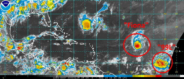
It’s mid-August and the heart of Atlantic hurricane season is quickly approaching; almost as if on que, we have a tropical storm (Fiona) in the central Atlantic, with another tropical wave behind it (designated “Invest 99L”) that is being monitored for development.

Fiona NHC

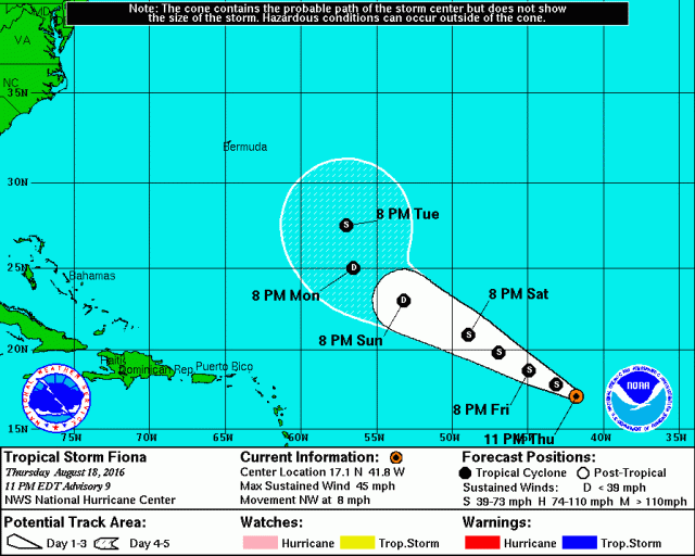
Let’s first start with Tropical Storm Fiona. The tropical storm is currently battling moderate shear that is expected to increase through the weekend. This should cause Fiona to weaken this weekend. Models suggest that the shear may decrease early to mid next week, which may allow for some re-intensification if Fiona can survive until then.

Fiona WV

Water vapor imagery shows the less than hospitable that lies ahead of Fiona over the next few days. An upper level trough axis (sometimes referred to as a Tropical Upper Tropospheric Trough or TUTT) is visible on the imagery, with a belt of stronger shear. The darker colors on this water vapor image also indicate dry air. As Fiona moves northwest directly into this fairly strong shear and drier air, it will likely weaken. It’s not impossible that the cyclone can’t survive the weekend given it’s not very strong right now and will deal with this unfavorable environment for a good 72 hours.

output_kpakk5

As for where Fiona tracks, assuming it survives the weekend as a tropical cyclone, it currently appears very unlikely that Fiona does anything other than recurve well east of the United States. Fiona is currently approaching a weakness in sub-tropical ridging, and as a large trough moves across the eastern US and breaks the heat this weekend, the weakness in ridging will expand while ridging becomes stronger to the northeast of Fiona. This eastern ridge will pull Fiona up through the weakness to the north by early next week. Although ridging begins rebuilding over the western Atlantic/eastern US as we head deeper into next week, Fiona will likely be far enough north to safely get caught up in the westerlies and whisked off to the east-northeast, away from land. This is a great example of why it’s rare for tropical cyclones that gain considerable latitude far east out in the Atlantic rarely go on to hit land in the western Atlantic, even if there’s ridging over the eastern US.

99L close IR

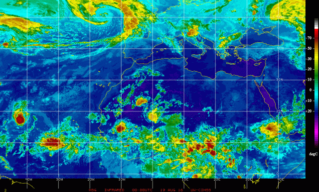
Behind Fiona, the next system to watch is Invest 99L, which is pictured above. Satellite loops don’t show a well-defined surface circulation yet with 99L, and the bulk of the relatively disorganized convection appears to possibly be displaced to the west/southwest of the strongest surface vorticity (spin). Microwave satellite imagery from Thursday afternoon of 99L shows little organization to the system’s convection, with no hints of a circulation or any banding features:

99L micro

This current lack of organization likely means development into a tropical cyclone probably won’t occur until later this weekend or early next week, as the system tracks towards the west or a bit north of due west.

GFS 99L 12

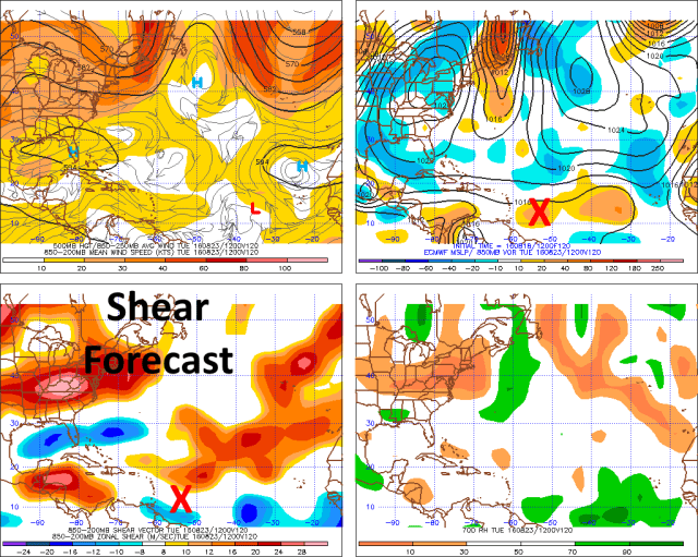
The environment around 99L (per very short term GFS model forecasts) isn’t currently extremely hostile, however it’s less than optimal. Fiona has done the dirty work and lessened the amount of dry air in its wake, which is conveniently where 99L is right now, however some north-northeast wind shear on the backside of an upper level ridge to the northeast of 99L is currently impacting the system (per the convection being displaced west/southwest of the “center” of 99L). This shear is expected to continue and turn easterly for at least a few days as 99L slides south of the upper level ridge:

GFS 99L 60

By early Sunday morning, the GFS still shows moderate (15-25 knots) easterly shear affecting 99L as it moves west. While this won’t completely preclude slow, gradual organization through the weekend, it will likely prevent rapid development over the next few days. As we head towards Monday and Tuesday of next week, the GFS shows 99L becoming a bit better co-located with the upper level ridge, allowing shear to decrease and some better divergent flow/outflow to possibly develop over the system:

GFS 99L 120

The Euro, although it isn’t very thrilled in the development prospects of 99L, also shows the system moving into a more favorable environment for development early next week:

99L ECM 120

Given the current lack of organization with 99L, the moderate shear expected through the weekend, but the improving conditions expected by early next week, I think Monday or Tuesday is a good target to watch for possible tropical cyclone genesis out of 99L. Since the system will be moving parallel to the shear vector, which may try to limit the shear’s impact on the system, and since there isn’t too much dry air around 99L, it’s not impossible we see development sooner…however, for now I’m going to be conservative and not expect much before early next week.

99L GFS 132

Where 99L tracks as we head into next week seems to be very dependent on how quickly it develops/intensifies. An open wave or weak tropical cyclone would likely continue moving west or west-northwest over the next several days as it follows the easterly trade winds in the tropical Atlantic. If the system intensifies, there will still be a weakness in the sub-tropical ridging over the central Atlantic, between stronger ridging over the east Atlantic and also over the southeastern US. A strong tropical cyclone east of about 70W would likely begin to turn northwest due to the weakness in the ridging aloft, and possibly recurve out to sea. A storm that doesn’t intensify until it’s farther west would likely be more influenced by the western portion of the sub-tropical ridge, and likely stay farther south.

99L GEFS

The GFS ensemble members show this very well; the members that intensify 99L quickest show a sharp turn to the north, while the weaker members maintain a more westerly track. The Euro ensembles, although I can’t show them here, do have a good chunk of members (roughly 10/50) that develop 99L into a robust tropical cyclone. Some show a re-curve, but others don’t develop it until farther west and show a potentially more threatening track.

ECM 192

The general weather pattern over North America and the western Atlantic at the end of next week, per the European ensembles, shows that the strongest sub-tropical ridging will be located over the southern US and eastern Atlantic. Although there isn’t a large trough in between, there may be enough of a weakness to cause a stronger tropical cyclone to curve north. Because of this possible weakness in the ridging, and considerable uncertainty over how quickly 99L possibly develops/intensifies, it is really tough to tell for sure whether or not 99L will threaten land at some point.

My guess is development is slow enough over the next few days that at the very least, a threat to Puerto Rico, the Virgin Islands, and Lesser Antilles is on the table for the first half of next week. Beyond that, it really is tough to call how strong 99L may get due to possible land interaction (Hispaniola) and possible shear from a series of TUTTs that may still be lingering around 20N, so it’s tough to guess on a track. It would take a certain series of events to get a threat to the US out of this system, it’s not impossible but for now I wouldn’t get excited. Once 99L starts developing further it will be easier to determine whether or not a threat to the US exists or not. If there is a threat to the US, it would likely be right around the beginning of September. That is quite a ways away, and a lot can happen to prevent such a threat from 99L, hence my current reservations.

Africa IR

Behind 99L, it is quite possible we have several more systems to possibly track as we head through the end of August and into September, which is the climatological peak of hurricane season in the Atlantic. Tropical waves are lined up over Africa, ready to move out into the Atlantic one after another. Some of our forecast models suggest the favorable upward motion (in green) associated with an MJO wave may move into the Atlantic by the end of August and into September, possibly further encouraging development of these tropical waves:

CFS MJO

It’s much too early to speculate on threats to land with anything behind 99L, assuming some of those waves can manage to develop into tropical cyclones, but my guess is we’ll have several systems to track somewhere over the Atlantic into early September.

Posted in Uncategorized | Leave a comment

4/28/16: Long-Lasting Supercell Brings Very Large Hail to SE Ohio, WV

One of the more impressive supercell thnderstorms Southeastern Ohio has seen over the last couple of years brought hail up to the size of tennis balls (2.5″ in diameter) to northern Athens County around 5:30PM Thursday afternoon! Imagine if that had hit Athens and OU. The radar imagery from this storm shows several tell-tale signs of a strong supercell and very large hail…

Logan hail 4-28

Athens hail 4-28

The first two images are pictures of the hail taken by members of the general public just south of Logan, OH (northwest of Athens) and in northern Athens County (exact location unknown) respectively. The first image appears to show hail between the size of golf ball and hen egg sized (1.75-2″)…the second image appears to show hail close to tennis ball sized (2.5″!). Trained weather spotters reported hen egg to tennis ball sized hail near both of these photos, so the pictures are legitimate. Yes, this hail fell less than 15 miles from Athens, OHIO on Thursday.

4-28 sup reflectivity

4-28 sup srv

The third image is a standard image of radar “reflectivity” of this thunderstorm as it passed near Nelsonville in northwestern Athens County at around 5:15PM. When you see radar images on the news, this is most likely the product they are showing you. Note the “hook” shape of the strongest radar returns (reds and purples), which is characteristic of a supercell thunderstorm (a thunderstorm that is rotating). I have also annotated a few features common in supercells that meteorology majors should be able to recognize. The forth image is an image of the winds detected by the radar in Charleston, confirming that this storm was rotating. This rotation was not strong or “tight” enough to produce a tornado. If the winds in the lower portions of the atmosphere were stronger on Thursday, it’s quite possible that this strong supercell would’ve produced a tornado north of Athens…however, that luckily wasn’t the case.

4-28 sup cross

4-28 RLX Volume 2

4-28 RLX Volume 3

The fifth image is a cross-section slice of the storm at the time of the “standard” radar images shown in images 3 and 4. A few interesting features can be noted here…the most obvious feature is the huge area of purple and even white (VERY intense radar returns) sustained through a very deep layer of the atmosphere. This deep layer of very intense precipitation in portions of the atmosphere that are below freezing is indicative of very large hail. The other insane thing in this image is the area of lighter radar returns below all of this hail. The upward winds (updraft) in this thunderstorm were so strong that they literally held this huge area of large hail aloft. For tennis ball sized hail to be maintained aloft, upward moving winds of over 75MPH are needed! That’s hurricane force winds blowing straight up in this thunderstorm!! (see this link for upward moving winds needed to generate a certain hail size: http://www.srh.noaa.gov/jetstream/tstorms/hail.html ). The sixth image shows the massive area of hail held aloft in a more 3D view…with the light blue representing the upper edge of the storm…over 40,000 feet high, almost 8 miles high! The seventh and final image is a similar 3D look, but with the image showing more of the lighter precipitation…it’s a little difficult to see, but you can see the area of light precipitation beneath the heavy rain/hail held aloft, where the updraft of the storm is strong enough to literally hold heavy rain and hail aloft.

Here are a few pertinent storm reports from the National Weather Service:

0455 PM HAIL 2 S LOGAN 39.50N 82.40W
04/28/2016 M2.00 INCH HOCKING OH PUBLIC

0545 PM HAIL 3 SE AMESVILLE 39.37N 81.92W
04/28/2016 E2.50 INCH ATHENS OH COCORAHS

CARS DENTED

0645 PM HAIL 4 NE ELIZABETH 39.10N 81.34W
04/28/2016 E2.00 INCH WIRT WV PUBLIC

TORRENTIAL RAINFALL

Posted in Uncategorized | Leave a comment

February 9-11th Lake Effect Snow Event

A long duration moderate to heavy lake effect snow event looks to bring decent snow totals to the primary and secondary Northeast Ohio Snowbelts Tuesday night through Thursday night…

snow 2-9 no neo

A low pressure will move drift from near London, ON to Upstate NY Tuesday into Wednesday, bringing winds around to the WNW and eventually NW across Lake Erie, while also allowing much colder air to flow in. An upper trough across the Great Lakes and New England will contain a couple of shortwaves and vort maxes rotating around that will help enhance any lake effect off of Lake Erie and keep the atmosphere moist. Upstream lake moisture will be present for a good chunk of the event. The NAM, GFS and Euro are all in surprisingly good agreement on the big picture and a lot of the specifics and have been for a few runs which adds some confidence to the forecast. Most images here are from the NAM as it tends to depict the Great Lake modification best.

NAM 500 27

Snow will likely increase Tuesday night as some modest synoptic lift drops across the lake behind the departing surface low. Some positive vorticity advection (PVA) associated with a vort max dropping across the lake will add some modest large scale ascent, and some weak low level convergence/frontogenesis between arctic air wrapping in from the southwest and a bubble of milder air closer to the surface low will also be present:

NAM 850 30

With deep moisture to nearly 25k feet Tuesday night, this weak large scale lift should support light synoptic snow dropping into northern OH Tuesday night. The lift isn’t strong so general accumulations will probably only be on the order of an inch or so outside of the Snowbelt.

NAM sfc 33

Over the Snowbelt, a trough is expected to extend west from the departing surface low Tuesday night into Wednesday morning, with warming from the lake combining with this trough to generate convergence and lift over the primary Snowbelt Tuesday night into Wednesday morning. Lake induced instability and equilibrium heights are rather marginal Tuesday night, but should be enough to combine with the convergence to yield moderate snow in the primary Snowbelt Tuesday night into early Wednesday:

BUFKIT 1

The winds over land won’t strongly back to the SW and at this point the air over land isn’t extremely cold, so the convergence and associated band of better snow should be able to push inland some from the lakeshore Tuesday night into Wednesday morning. With NW to SE oriented isobars which argues for the banding getting into Cuyahoga County and a WNW flow at 850mb, suspect that the band of better snow will affect northeastern Cuyahoga, southern Lake, northern and central Geauga, inland Ashtabula and inland Erie Counties Tuesday night. As for snow rates/amounts…deep moisture and modest synoptic lift combined with low level convergence and some lake induced instability could certainly yield steady light to moderate snow. Although a W flow isn’t ideal for upslope, with very moist low levels and steep lapse rates in the lowest few thousand feet the higher terrain may add enough lift for minor upslope enhancement as well. Snow ratios will be OK Tuesday night but not great…the DGZ will be saturated and fairly deep, but the best omega undershoots or barely gets into the DGZ. I suspect ratios will be on the order of 15-18:1 owing to the deep and saturated DGZ but only some of the better lift getting into it. Given the prolonged nature of steady light to at times moderate snow and OK snow ratios Tuesday night, suspect 3-4” amounts will be common in the areas outlined above. Some locally higher amounts of up to 5” may be possible in southern Lake/northern Geauga as they always do well in this type of flow and possibly in the higher terrain in Erie County where the large scale lift may be more favorable.

NAM sfc 42.png

During the day Wednesday the surface low is expected to continue pulling east, pushing the surface trough a little farther south. This should spread the lake effect band farther southwest. Winds remain fairly WNW on Wednesday and there’s evidence of some convergence persisting in the Snowbelt, possibly due to colder air and somewhat higher pressures trying to nose east through the Ohio Valley. The modest synoptic lift and associated light snow should shift east/southeast Wednesday morning and lake to 850mb temp differentials will increase to 15-17C, which will allow the snow to take on more pure lake effect characteristics Wednesday morning. Lake effect conditions are OK Wednesday morning, but deep moisture remaining to 10-15k feet and convergence along the trough trying to push inland I suspect moderate snow will continue with the band along the trough. Snow ratios may increase a little Wednesday morning as the atmosphere cools a bit more and the DGZ lowers into the better lift.

BUFKIT 2

By Wednesday afternoon lake induced instability and equilibrium levels start increasing to more respectable levels as colder air streams in. Deep moisture remains present to above 10k feet thanks to the upper trough overhead and lapse rates are almost absolutely unstable in the lowest 5k feet. There is a little bit more wind shear above 850mb here which along with the winds trying to push the trough inland may cause the LES to become more disorganized for a time Wednesday afternoon.

NAM stream 42.png

Even with that said…the increasing instability and still plenty deep moisture, along with very steep low level lapse rates suggest that decent snow showers will still continue. Ratios should climb above 20:1 in this timeframe per the above sounding with more of the upward motion in the DGZ and with good instability through the whole DGZ. Low level streamlines above suggest that a Superior-Michigan-Erie connection will be in play with a broad WNW or NW flow across the region into the Cleveland metro and primary Snowbelt, which along with decent instability and very good moisture should allow fairly good snow to continue in the primary Snowbelt. The snow may be less organized which could keep rates from getting out of control, but it should keep snowing. Very steep low level lapse rates and good moisture along with a more favorable flow for upslope will also help the higher terrain in this timeframe. The surface trough may shift far enough south that moisture from southern Lake Michigan combined with the layer of steep lapse rates and loose convergence along the trough could allow for disorganized but briefly moderate to heavy snow showers to occur very far inland, possibly as far inland as parts of Ashland, Medina, Summit, northern Stark and Mahoning Counties.

Overall during the day Wednesday I’m thinking an additional 3-6” in the higher terrain of the primary Snowbelt owing to the snow becoming less organized at times but still being moderate to heavy under any snow showers with good ratios. I could see 2-4” amounts in parts of Medina, Summit and Portage Counties, especially in the higher terrain due to the surface trough settling south towards these areas as the winds gain more of a northerly component and due to good flow for upslope and also moisture from southern Lake Michigan.

NAM 500 48

A fairly potent and negatively tilted shortwave is shown by all models to move across Ohio Wednesday evening. This shortwave will initially bring some large scale ascent ahead of it along with an increase in moisture, which will probably cause any snow showers outside of the lake effect to flare up and cause the lake effect to increase in intensity late Wednesday afternoon into Wednesday evening as the shortwave approaches and passes. The shortwave will also cause a response in the surface wind fields and cause winds to back a little more westerly late Wednesday afternoon/early evening before going more northwesterly behind it later Wednesday evening. This may cause convergence to increase near the lakeshore late Wednesday afternoon and early evening and cause a potentially transient single band to redevelop, before the band swings southwest Wednesday evening and multi-bands take back over.

BUFKIT 3.png

Forecast soundings from Wednesday evening as the shortwave moves by are fairly impressive, with very steep lapse rates extending to near 5k feet and lake induced equilibrium levels rising to near 10k feet. Moisture is very deep and shear is a bit less than earlier Wednesday afternoon. Very steep lapse rates and strong upward motion centered in the DGZ suggest very efficient snow ratios, possibly climbing to 25 or 30:1.

NAM sfc 48

The NAM shows an increase in convergence just south of the lakeshore thanks to the wind shift associated with the shortwave, which if it verified would likely allow a more dominant single band to redevelop for a few hours Wednesday evening. With a more WNW flow in this timeframe the single band could certainly affect the Cleveland metro and western lakeshore for a time before swinging south and weakening. Outside of the potential transient single band, farther south there are still signs of remnant convergence from the first trough that pushes south earlier on Wednesday, with differences between lake modified air to the north and colder air farther south likely contributing to some loose convergence well south of Lake Erie Wednesday evening. There’s a clear fetch off of southern Lake Michigan into areas from Ashland to Akron/Canton to Youngstown if not a hair farther south with this flow, so with the added moisture/lift form the shortwave, good ambient moisture/instability, some Lake Michigan moisture and loose convergence, this strikes me as a situation where less organized but still very intense snow squalls occur Wednesday evening well outside of the Snowbelt, with local quick accumulations of a couple of inches.

BUFKIT 4

As mentioned, behind the shortwave late Wednesday evening through Wednesday night the winds go more northwesterly, but become very well aligned. Instability becomes moderate to extreme with lake to 850mb temp differentials pushing 20-22C and lake to 700mb temp differentials of 28-30C, with lake induced equilibrium levels of 9-10k feet. Moisture does start stripping away aloft later Wednesday night as the upper trough finally starts pulling away, which may make upstream connections much more important as this turns into a short fetch event with less than stellar ambient moisture. This regime supports potentially moderate to heavy snow showers with still high to very high ratios in any upstream lake connections but probably just flurries or light upslope snow showers outside of these connections.

NAM stream 60

Streamlines on the NAM suggest that some semblance of a connection to lower Lake Michigan may shift into parts of central Ohio and possibly affect the central highlands near Mansfield with snow showers by late Wednesday night and Thursday morning, with a potential Superior-Michigan-Erie connection into the Cleveland metro, secondary Snowbelt and western primary Snowbelt. This is quite a typical location for this connection with an almost due NW flow. The Lake Huron connection should try to effect NW PA with a NW flow as well. With plenty of instability and very well aligned winds supporting good inland propagation of bands and also moderate to locally heavy snow where moisture is sufficient, the three lake connection near Cleveland may continue to produce moderate to locally heavy snow into Thursday morning, especially in the higher terrain. The heaviest snow may occur in the Lake Huron connection. The southern Lake MI connection doesn’t have a lake immediately nearby so it will probably produce mainly light amounts into the central highlands late Wednesday night into Thursday morning. We’ll have to watch the potential for a sliver of drier air to work down from near Sault St. Marie across eastern lower MI towards parts of the primary Snowbelt in this timeframe, which sometimes happens in a NW flow. With no or very little ice on the upper Great Lakes I’m hoping this can be minimized…it normally takes a NNW flow to bring that drier air into the Cleveland metro and the wind looks more NW with this event, which may allow snows to continue in and around the Cleveland metro as discussed.

Additional amounts from late Wednesday afternoon through Wednesday night associated with the shortwave passage and then multi-bands later at night of 3-6” again seem reasonable in the higher terrain of the primary Snowbelt, with locally more possible if the three-lake band can establish itself well or if the brief single band with the trough passage is intense over one area for a little bit. I also think a few inches will fall in the higher terrain in the secondary Snowbelt due to an uptick with the shortwave and also favorable upslope behind the shortwave, with some possibility of the three-lake band swinging into this area. Also think a general inch to locally three outside of the Snowbelt due to good snow squall parameters as the shortwave passes.

BUFKIT 5

Instability and moisture parameters may not change a ton Thursday or even into Thursday night (before finally crashing by Friday AM) which could allow moderate lake effect to continue into Thursday night. The big change will be stronger ridging nosing in from the west and turning the winds more WNW Thursday afternoon and then SW Thursday night. This will push the upstream lake connections east rather quickly Thursday afternoon but may allow some convergence to redevelop from Cuyahoga County points east that then shifts up the lakeshore Thursday night. This could allow an additional 2-4” to fall in favored areas Thursday with maybe 1-3” along the eastern shoreline Thursday night.

Total snows of over a foot seem quite likely over the higher terrain in the primary Snowbelt…from parts of eastern Cuyahoga County east through central and northern Geauga, far southern Lake, inland Erie and northern Crawford. Local amounts of over 18” are possible in northern Geuaga/far southern Lake as well as parts of inland Erie County where many phases of the event could perform well. The secondary Snowbelt in southern Cuyahoga, northern Medina and northern Summit Counties…as well as parts of Portage and Trumbull…could have a pretty good window Wednesday afternoon through Thursday evening and could see several inches. Local amounts exceeding over 8” in the true secondary Snowbelt (SW Cuyahoga, N. Medina, NW Summit) wouldn’t completely shocking of a good three-lake band can setup Wednesday night into Thursday morning. Due to a few windows for snow showers and possibly squalls to make it well inland, a couple to locally few inches may fall by Thursday night from the higher terrain near Mansfield east as far south as Stark and Mahoning Counties.

Posted in Uncategorized | Leave a comment

January 17-19th, 2016 Lake Effect Snow Event


snow 1-17 no neo

What could be the largest lake effect snow event of the season in Northeastern Ohio is imminent as a lobe of the polar vortex brings the coldest air of winter thus far over the almost completely unfrozen waters of Lake Erie over the next couple of days.

NAM 18 500


A cold front will move through NE Ohio and NW PA early to mid-afternoon on Sunday, with arctic air behind the front. This front will be passing through as a modest shot of positive vorticity advection (PVA) along with lift on the nose of a low to mid-level jet and in the left-exit quadrant of an upper level jet are all intersecting over the area as the front moves through. With forecast soundings showing nearly saturated profiles up to about 15K feet as the front goes through, I certainly think this large scale lift will set off a general area of light snow late Sunday morning into the early afternoon across NE OH and NW PA. As the front moves through, forecast soundings show steep lapse rates and a little bit of CAPE into the snow growth zone (DGZ) which when combined with strong convergence/low level lift with the front itself will likely result in some snow squalls developing along the front:

BUFKIT 1

A forecast sounding for CLE off of the 0z 4km NAM as the front approaches shows the deep moisture (and weak lift in the mid-levels associated with the large scale lift discussed above, the white line is vertical motion, to the left is rising/upward motion), along with some CAPE to about 6k feet and through a good portion of the DGZ. This supports the notion of a general light snow for a couple or few hours with squalls along the front where low level lift will be maximized. In addition, there will already be some lake induced CAPE, so the squalls over the Snowbelt may pack a bit more of a punch along the front as the lake will add some additional instability.

All in all, think the period of light snow and brief embedded squalls along the front will produce a general inch or so of snow for most of NE Ohio, with perhaps 2-3” in the primary Snowbelt in NE Ohio and NW PA where more instability will likely strengthen any snow squalls along the front. Ratios may be mediocre outside of any squalls which will likely limit over-performing potential with the synoptic snow.

After the light amounts of synoptic snow, the attention will inevitably turn to lake effect snow as a very deep and cold upper low moves across the Great Lakes.

NAM 30 sfc


There will likely be a period late Sunday afternoon and into the evening behind the frontal passage where lake effect takes some time to organize…which is fairly common…note how by 1AM Monday, the NAM is still just starting to develop better convergence across the Snowbelt. However, the above temperature/pressure pattern appears favorable for a strong, single band to eventually form from Cuyahoga County points east with NW to SE oriented isobars, a surface low pulling away to the east, some hints at a lake aggregate trough developing in the isobars, and another little trough evident in the isobars over southern Lower MI.

BUFKIT 2

Even if any bands struggle to consolidate some for a time Sunday evening, forecast soundings still suggest some decent moderate bursts of snow in the primary Snowbelt with W or WNW winds, moisture to 5k feet or so and equilibrium levels of near 11k feet. Forecast soundings from Erie are even gaudier with the instability Sunday evening with EQ levels near 13k feet and slightly warmer lake waters. I’d have to suspect that moderate to heavy orographic lift snows will occur in the higher terrain in inland Erie County and northern Crawford County Sunday evening even without a well-organized band due to the long fetch, extreme instability, pre-seeding and a fairly well-aligned flow.

NAM 36 sfc

The NAM and Euro both agree on convergence really increasing across the Snowbelt after 1AM Sunday night into Monday morning as a trough drops southeast across Lake Erie while pressure rise over land and temps cool into the single digits inland.

NAM 33 500

The trough dropping across the lake appears to be a result of another lobe rotating around the PV and moving across Lake Erie and northern OH/NW PA late Sunday night into Monday morning. This should provide some modest upward motion to enhance the lake effect further. In addition, this little lobe brings the coldest temps aloft, with 500mb temps bottoming out over the lake at near -40C early Monday morning. With lake to 850mb temp differentials of 22-24C…lake to 700mb differentials of 31-33C…and lake to 500mb differentials of 40-44C late Sunday night into Monday morning…along with some weak synoptic lift, a connection from Lake Michigan, and strong convergence over the Snowbelt, I have to expect a very focused and strong band to occur after midnight Sunday night into Monday morning as the trough approaches and pushes across the lake. Snow rates could briefly max out at 3” per hour under the band as the trough pushes into the lakeshore communities early Monday morning and maximizes convergence.

BUFKIT 3

A forecast sounding for CLE off of the 0z 4km NAM valid Monday morning as the trough is pushing through shows a deep layer of instability with high equilibrium levels and well-aligned winds. The DGZ is confined to the lowest 3-4k feet due to the very cold air, but the model shows the lowest 2-3k feet of the cloud layer being in the DGZ with the strongest upward motion also in the DGZ. So although the cold may keep ratios of getting to very high values such as 30-40:1, I think 20:1 is still very much doable Sunday night into Monday morning which will allow for relatively efficient accumulations. Forecast soundings for Erie are even more impressive, with equilibrium levels near 15k feet and around 1000 J/KG of lake induced CAPE…supportive of very heavy snow rates.

NAM 33 850

As for band placement Sunday night into Monday morning…the NAM surface winds suggest it’ll be focused from extreme NE Cuyahoga east across southern Lake, northern Geauga, southern Ashtabula and into southern Erie/northern Crawford Counties. However, the isobar orientation as seen a few images up is a very close match to previous Cuyahoga County single band cases, and 850mb winds seen in the above image are in the 290-300 range over NE Ohio and the lake, which suggests winds over the lake should try to take on a pretty good northwesterly component and push the band inland a little bit. Everything suggests the band should sit 5-10 miles farther south than the band last Tuesday night sat. The 0z ARW has the band from near Avon east across most of northern and central Cuyahoga County east into Geauga County, with the heaviest just south of 322. The NMM is a bit farther north and takes the best band from Cleveland and Bratenahl ESE and is more centered right on 322. The winds backing some over land do give me pause on bringing the band too far south so I tend to think that the NMM is closer on band placement Sunday night into Monday morning as the trough approaches. Think there could be a 4-6 hour window from about 2AM-7AM (give or take an hour) where the band moves very little as the trough approaches, with the band swinging south into more of Cuyahoga and southern Geauga Counties *briefly* immediately behind the trough, before starting to slowly drift back north. There could be significant accumulations in that window where the band sits. In NW PA with a due west or WNW wind ahead of the trough, think the banding will stretch from northern Ashtabula east across inland Erie and northern Crawford for several hours, with snow rates of 1 to perhaps 2” per hour at times over the higher terrain given the very strong instability and lift with the trough. Could also see rates locally max out higher here too as the trough pushes inland and really enhances convergence for a time.

NAM 48 sfc

During the day Monday expect the band to start lifting back northeast up the shoreline as high pressure noses in ahead of the next trough and backs winds a good bit. The band could very well disorganize for a few hours Monday morning behind the trough which is again, typical, but with continued extreme instability and a long fetch, I’d still expect moderate to heavy snow showers in the primary Snowbelt, perhaps favoring the higher terrain some…they just won’t be as organized. By Monday evening the models are really increasing convergence across Ashtabula and Erie Counties as temps start dropping again inland and high pressure continues to nose into the Ohio Valley, with another trough evident to the north starting to drop down. This suggests the band should start becoming more focused again by later Monday into Monday evening.

BUFKIT 4

Forecast soundings from Erie for Monday evening off both the 12km NAM and 4km NAM show continued high EL’s, good moisture, fairly well aligned winds and very strong lift in the DGZ. As convergence increases Monday evening and the band re-orgnizes I’d expect heavy snow rates of 1-2” per hour to resume. During the day Monday it takes until about mid-afternoon for the winds over the lake to go due west, so the snow showers may affect northeast Cuyahoga, central and northern Geauga, southern Ashtabula, and at least northern Crawford County into the early to mid-afternoon before activity becomes focused farther northeast. With due west winds over the lake by Monday evening with WSW or even SW winds over land, I’d have to suspect the band will end up fairly far northeast, into perhaps northern Ashtabula and certainly into Erie County.

NAM 54 500

The potential for a well-organized, stable band Monday evening appears to be decent as one last good shortwave rotates in from the north late Monday night into Tuesday morning. This should bring another surface trough south across the lake late Monday night, increase mid-level moisture some and also provide some modest synoptic lift into play.

NAM 57 700

Most models I looked at (NAM shown above) do show a nice lobe of mid-level moisture dropping south-southeast across the lake late Monday night into early Tuesday with the shortwave. This all suggests pretty good snow rates beneath any band Monday night into Tuesday morning.

BUFKIT 5

Forecast soundings from Erie overnight Monday night, while not as impressive as earlier in the event, are still good, with lake to 850mb and lake to 700mb temp differentials remaining near or better than 20C and 30C respectively suggesting extreme lake induced CAPE, along with equilibrium levels remaining near 10k feet…along with good moisture to about 8k feet and some moisture to about 13k feet, well aligned winds in the low levels and good upward motion in the DGZ. Snow rates of 1 to at times 2” per hour should be attainable with that kind of profile in any well-organized band Monday night.

NAM 57 theta

As the trough drops south early Tuesday and starts turning the winds more NWrly over the lake while winds remain WSW or SW on land, convergence will become very strong over the Snowbelt from northern Lorain and Cuyahoga Counties points east Tuesday morning. This supports snow rates again maxing out at potentially 2-3” per hour briefly as the trough starts pushing south early Tuesday.

BUFKIT 6

NAM forecast profiles for CLE still look decent Tuesday morning…easily supportive of heavy snow rates given the expected strong convergence as the trough approaches and then pushes south.

The trough could bring winds around to the NW enough to push the snow farther inland Tuesday morning than Monday morning…possibly getting into most of Lorain and parts of Medina/Summit/Portage for a time…before the high starts building back in and backing the winds again. Behind the trough inversions really crash on Tuesday and remain at 4-5k feet through the day. The activity should start shifting back northeast on Tuesday into the primary Snowbelt but will mainly be light by that point with just minimal additional accumulations.

BUFKIT ERI

BUFKIT CLE

BUFKIT time-height profiles for CLE and ERI from the low-res NAM indicate high humidity (color fill) and good lift (red contours) in the DGZ (purple/white contours in the lower portions of the images) throughout the event…with clear bullseyes when convergence and hence banding could very well be maximized at each location. This suggests moderate to heavy snowfall in the bands through the event with many areas seeing multiple possible windows of banding. Snow ratios will probably be good due to good lift and humidity in the DGZ but not great due to the cold suppressing the height of the DGZ.

As for specific amounts…expect 2-3” in the primary Snowbelt with the frontal snow through Sunday afternoon and an inch…locally a bit more elsewhere. Expect light accums Sunday evening before the band really organizes from eastern Cuyahoga County points east, especially in the higher terrain inland. Expect banding to flare up for several hours late Sunday night into Monday morning with little movement and heavy rates…think an additional 4-8” is quite possible where this banding sets up, possible near 322. NW PA will also see good snow in the orographic lift areas in this timeframe and will probably see a better band or two as well wherever upstream moisture from Lake Michigan makes it and possibly downwind of upstream bays over northern/western Lake Erie, which are often initiation points for bands. Think 5-9” in inland NW PA in this timeframe as it should snow just about all night with moderate to heavy snow for several hours after midnight. The banding should sag south briefly Monday morning and possibly drop an inch or two as far south/west as I-80. Expect the band to break up some Monday morning behind the trough and slowly push north through the day. Think maybe another 1-3” in NE Cuyahoga, Lake, northern/central Geauga, Ashtabula, Erie and northern Crawford in this timeframe, least near the lakeshore and most in the higher terrain.

Expect a better band to develop Monday evening near the lakeshore in Ashtabula into Erie County PA. The lakeshore in Erie County could get hit decently in this timeframe as well as winds on land really try to back. This band looks to have a several hour window of little movement and moderate to heavy snow and should produce another 4-8” where it sits Monday night, before pushing south early Tuesday. The band should persist for a couple hours or so as it pushes back southwest across northern/eastern Cuyahoga, southern Lake and Geauga and could produce a quick 2-4” or so as it goes…with lighter amounts possible again about as far south as I-80 Tuesday morning. Think another 1-2” in the primary Snowbelt (mainly in the higher terrain) from mid-Tuesday morning through Tuesday afternoon as the event winds down.

Totaling things up, get two areas where banding looks to be persistent for longest…parts of eastern Cuyahoga into northern/central Geauga…and also inland Erie County PA. Totaling things up in these areas am getting about 18-24” in parts of inland Erie County…with 12-18” in surrounding portions of Erie County, northern Crawford County and perhaps adjacent far eastern Ashtabula where there are some hills. Am also getting 10-20” in northern/possibly central Geauga County and far eastern Cuyahoga County along 322 and east of 271. Will call that 12”+ because I’m not sure they’ll get near the top end of the 10-20” range unless the band really sits in one area. There will be a couple of windows for banding along the western lakeshore west of Downtown although the banding looks more persistent farther east, so will bring moderate amounts into the western lakeshore, and put a little additional snow in for lake effect as far south/west as northern Lorain/northern Medina/northern Summit/northern Portage. The lakeshore in Lake County looks to see mainly transient banding and may struggle to see 6” or so over the course of the event. Will go a bit higher in NE Ashtabula as they could be under banding Monday night. Parts of Ashtabula may be in a bit of a whole between banding throughout the event as they often are but there will be plenty of window for snow…so I think inland Ashtabula can squeak out 8” or so over the course of 48 hours but the heaviest probably will be elsewhere.


Posted in Uncategorized | Leave a comment

Cuyahoga County Heavy Single Banded Lake Effect Snow Event SLP Patterns

In an effort to identify scenarios that support heavy, single banded lake effect snow into Cuyahoga County, I looked at several recent warning criteria lake effect snow events in Cuyahoga County that were caused by a single band of heavy snow (not multi-banded and/or orographic lift, or lake enhanced snow). The sample size is small but potentially useful. These events were off the top of my head as I’m quickly throwing this together, I’m sure I missed some events in the late 2000s.

The following are surface maps from warning criteria, single banded events in Cuyahoga County that effected a fairly large portion of the county with heavy snow events. Surface maps are from the approximate time of maximum snow intensity:

April 7th, 2007:

4-7-7 sfc.gifLink to surface maps from this date for you to scroll through as you please:

http://www.wpc.ncep.noaa.gov/archives/web_pages/sfc/sfc_archive_maps.php?arcdate=04/07/2007&selmap=2007040712&maptype=namussfc

This was a part of a long duration, significant and out of season event. A heavy band of snow developed from the northwest portions of Cuyahoga County and set up east or slightly south of east towards the southeast portion of the county towards Solon and Chagrin Falls. Amounts from the band were in the 6-10″ range.

The isobars over Lake Erie and Northeast Ohio are roughly oriented NW to SE, with a clear surface trough evident over central lower Michigan dropping south or southeast. There is a surface low over south-central Quebec and a surface high extending from western Manitoba south across the central Plains.

April 8th, 2007:

4-8-07 sfc

Link to maps from this date:

http://www.wpc.ncep.noaa.gov/archives/web_pages/sfc/sfc_archive_maps.php?arcdate=04/08/2007&selmap=2007040812&maptype=namussfc

This was a part of the same event described above, just a day later. A band of heavy snow redeveloped on the evening of the 7th into the morning of the 8th, a few miles farther north than the previous night. The band set up from near downtown Cleveland east towards east-central Cuyahoga County, with heaviest amounts near or just south of the 322 corridor in eastern Cuyahoga County. Amounts with the band were up to a foot on the east side.

The isobars are oriented a little more WNW to ESE, with a stronger surface low near the northern tip of Nova Scotia and the surface high slightly farther east extending from central Manitoba south across the Plains. A clear surface trough is evident across central lower Michigan.

December 8th, 2010:

12-8-10 sfc.gif

Link to maps from this date:

http://www.wpc.ncep.noaa.gov/archives/web_pages/sfc/sfc_archive_maps.php?arcdate=12/08/2010&selmap=2010120821&maptype=namussfc

Anyone who lived in Cleveland into December of 2010 should remember this event. A band of heavy snow developed across northern and eastern Cuyahoga County during the morning on December 8th and intensified during the afternoon while remaining nearly stationary. The heaviest snow affect the western lakeshore and downtown Cleveland (with over 10” of snow near downtown) and extended east into much of eastern Cuyahoga County, with even Solon receiving warning criteria snowfall. The band shifted south and weakened during the evening of the 8th. This came at the end of a significant, multi-day lake effect event.

The isobars are roughly oriented northwest to southeast, with a clear trough near or just north of Lake Erie. There is a surface low located east of Hudson Bay and a surface high extended from near the Ontario/Manitoba border south across the Mississippi Valley. A nose of higher pressure extends east across the Ohio Valley as well.

January 2nd, 2012:

1-2-12 sfc.gif

Link to maps from this date:

http://www.wpc.ncep.noaa.gov/archives/web_pages/sfc/sfc_archive_maps.php?arcdate=01/02/2012&selmap=2012010212&maptype=namussfc

This occurred at the beginning of a warning criteria (but not incredibly notable) lake effect event for the primary Northeast Ohio Snowbelt. A snow band developed across the eastern lakeshore in Lake and Ashtabula Counties overnight on the 1st into the 2nd and shifted into eastern Cuyahoga County on the morning of the 2nd and persisted for a few hours, before shifting south and dissipating. Warning criteria snow occurred during a 12 hour period during the daylight hours on the 2nd in portions of east-central Cuyahoga County. This is a marginal case.

The isobars are oriented roughly northwest to southeast, with a surface low located southeast of Hudson Bay. High pressure extended from central Manitoba south-southwest towards central Texas. A surface trough is evident over northern lower MI and central Lake Huron and is analyzed as a cold front on this map.

January 22nd, 2013:

1-22-13 sfc.gif

Link to maps from this date:

http://www.wpc.ncep.noaa.gov/archives/web_pages/sfc/sfc_archive_maps.php?arcdate=01/22/2013&selmap=2013012218&maptype=namussfc

This was a part of a fairly decent multi-day event in the primary Snowbelt mainly east of Cleveland. A single band of snow developed across northern and eastern Cuyahoga County late in the evening on the 21st and persisted into the morning on the 22nd, before shifting south and weakening by late morning on the 22nd. The heaviest snow occurred from the lakeshore in Cleveland east towards the eastern suburbs such as Lyndhurst and Mayfield. Amounts from the band were over 6″.

The isobars are roughly oriented northwest to southeast, with a clear surface trough analyzed as a stationary front extending across northern Michigan and Lake Huron. A smaller surface trough is analyzed in southeast Michigan but has a minimal impression on the pressure field. A surface low is located off the New England coast, with high pressure extending from North Dakota south-southeast towards Illinois and Arkansas. A nose of higher pressure extends east through the Ohio Valley.

October 24th, 2013:

10-24-13 sfc.gif


Maps from the date:

http://www.wpc.ncep.noaa.gov/archives/web_pages/sfc/sfc_archive_maps.php?arcdate=10/24/2013&selmap=2013102412&maptype=namussfc

This was one of the most significant October lake effect snow events that Northeast Ohio has seen in recent memory. A snow band developed in the evening of the 23rd, initially across northern and eastern Cuyahoga County east into Geauga County, before shifting north into Lake, northern Geauga, and Ashtabula Counties for a few hours. The band settled back south into northeastern Cuyahoga County early in the morning on the 24th and was persistent through most of the afternoon from over or just north of downtown Cleveland east towards Mayfield, at times getting as far south as Beachwood, but generally a little farther north. Snowfall amounts of near 8” occurred in Mayfield Heights. If this occurred when it was colder, snowfall totals of 1 to 2 feet very well could’ve occurred on a fairly widespread basis. The band shifted south and weakened during the evening on the 24th.

The isobars were generally oriented WNW to ESE…however, a very well-defined trough moving across the lake had a strong impression on the pressure field downwind of the trough in Northeast Ohio. A low was located east of Hudson Bay with a high extending from southeast Alberta towards Kansas. A small area of higher pressure extended east through the Ohio Valley.

November 14th, 2014:

11-14-14 sfc


Maps from the date:

http://www.wpc.ncep.noaa.gov/archives/web_pages/sfc/sfc_archive_maps.php?arcdate=11/14/2014&selmap=2014111412&maptype=namussfc

This was a part of a multi-day event focused from northern Lorain County points east. A strong band of heavy snow developed along the eastern shoreline from Lake County up through Erie County PA on the 13th, with some areas receiving over a foot of snow during the day on the 13th. That first single band swung southwest during the evening and produced a quick couple inches or more of snow as it went as far west as parts of central Lorain County, before the band broke up and multi-bands took over for a time. A single band re-organized early in the morning on the 14th from northern Lorain County east across a large portion of Cuyahoga County and southern Geauga County and persisted for several hours, before becoming more diffuse in the evening on the 14th. The second band allowed portions of eastern Cuyahoga County to reach the 24 hour warning criteria of 8” or more of snow.

The isobars were oriented northwest to southeast, with a modest surface trough evident from central Lake Huron points west. A surface low was located well off the New England coast, with a surface high across the eastern Plains. Higher pressures extended east through a good portion of the Ohio Valley.

November 20-21st, 2014:

11-21-14 sfc


Maps from the data:

http://www.wpc.ncep.noaa.gov/archives/web_pages/sfc/sfc_archive_maps.php?arcdate=11/21/2014&selmap=2014112106&maptype=namussfc

This event came at the end of a multi-day event that dropped feet of snow on western New York south of Buffalo. A well-established single band pushed southwest across the lake late in the afternoon and into the evening on the 20th and swung through Cuyahoga County fairly quickly, before stabilizing for several hours from northwestern Lorain County east-southeast into southwestern Cuyahoga County, just south of the airport. Snow totals of up to 6” occurred in parts of southwestern Cuyahoga County. The band quickly broke up on the morning of the 21st as high pressure moved in lowering inversion heights and as winds turned more northwesterly.

The isobars when the band stabilized across parts of Cuyahoga County were oriented NW to SE, with a clear trough near the south shore of Lake Erie and another one farther northwest across central lower Michigan and Lake Huron. A surface low was located north of Maine and a surface high stretched from Iowa to Kentucky.

November 27th, 2014:

11-28-14 sfc


Maps from this date:

http://www.wpc.ncep.noaa.gov/archives/web_pages/sfc/sfc_archive_maps.php?arcdate=11/28/2014&selmap=2014112800&maptype=namussfc

This was a short duration, high intensity event. The event started early in the morning on the 27th as a surface low moved up the East Coast and swung the winds around from NE to NW. Multi-banded lake effect with some Lake Huron connection developed into the west side early in the morning and quickly swung east across the Cleveland metro into the primary Snowbelt and dissipated by late morning. 1-2” of snowfall fell in parts of the metro with this portion of the event. The snow essentially ended for several hours before a surface trough dropped across the lake during the evening and produced a single band of heavy snow into northern Lorain, southern and eastern Cuyahoga, far northern Summit, southern Geauga and northern Portage Counties for a few hours, before the trough shifted south causing the band to shift south and break up. Snowfall rates of 3” per hour were observed at CLE and some areas received 6” of snowfall in under 3 hours, making this a warning criteria snowfall.

A surface low during the time of the band was located northeast of Nova Scotia, with a surface high extending from Iowa to Mississippi. A surface trough was located over Lake Erie when the band occurred. Isobars were located north to south north of the trough and NW to SE south of the trough.

Summary:

Every event featured isobars oriented a pretty true NW to SE. A couple of events had isobars slightly more westerly than northerly, but were generally oriented NW to SE or very close to it. Every event featured lower pressure somewhere to the east or northeast, with an inverted trough extending back towards the Great Lakes. Most of the events that locked a band in for more than a few hours also had high pressure extending east from the central US into the Ohio Valley…events like 11/27/14 and 1/2/12 that were more marginal and didn’t feature a well-organized band for more than a few hours didn’t have higher pressure nosing into the Ohio Valley as well as the other events did. Every event had at least a subtle surface trough over Lake Erie or not far to the north.

It seems that for a single band of lake effect snow to produce warning criteria snow into a good portion of Cuyahoga County, a few things are needed (other than the obvious proper moisture/instability for a strong lake response):

-Low pressure to the east or northeast with an inverted trough extending towards the Great Lakes. The inverted trough doesn’t seem to be required as a couple of good events didn’t have it, but most events do have a feature like that.

-At least a subtle surface trough over the lake or just to the north of the lake. An inverted trough extending west from a surface low to our east or northeast can serve this purpose.

-Isobars oriented northwest to southeast. More WNW to ESE isobars may still clip the extreme NE corner of the county but would likely miss a majority of the county.

-High pressure nosing into the Ohio Valley appears to make it more likely for bands to lock into place for more than a brief period of time.

-High pressure placement to our west doesn’t seem extremely important, as long as the high is centered to the west somewhere with preferably some higher pressure extending east into the Ohio Valley.

Shortfalls:

Obviously this is a small sample size off the top of my head. There is the possibility that other seemingly favorable environments with similar pressure patterns didn’t produce, so this doesn’t scratch the false alarm rate of using isobaric patterns to predict if a single band of lake effect snow will occur in Cuyahoga County or not. Only warning criteria events were used…shorter duration events that only produced advisory snowfall were not explored as again, this sample was off the top of my head. More obviously goes into lake effect forecasting than the isobaric pattern, however, all 9 events featured very similar patterns so I believe this information can still be useful.

Posted in Uncategorized | Leave a comment

January 12-13, 2016 Snowfall Verification Map

snow 1-12 to 13 actual

A few notes on the map itself:

-There were few spotter reports in eastern Ashtabula County and western inland Erie County that were “reliable”…I say this because there were a few spotters that called in for parts of the event but didn’t for others when I knew they got snow. The only good reports in that area were a spotter that had a total of 13″ just NW of Edinboro, along with 11″ from a spotter near Pierpont. Radar overshoots LES badly in Ashtabula/Erie/Crawford so unfortunately I had to do a lot of guessing there based on terrain, surrounding reports and what radar happened to picked up there.

-The only good reports in eastern Cuyahoga County and western Geauga County were a total of 8.8″ in Euclid from a trained spotter…11″ 2.5 miles north of 322 from a veteran weather enthusiast, and 4″ in Newbury/South Russell from two separate veteran weather enthusiasts that I trust. Luckily radar doesn’t overshot LES there so I feel much better about that area, but the lack of reports and sharp cutoff mean I may be a little off. The 8” edge looks jagged in NE Cuyahoga, however, that is supported by radar, as there was a good period where the band absolutely ripped on Euclid but areas immediately southwest weren’t getting good snow, and a period of time earlier on in the evening when the band was farther south where heavier returns were consistently just east of 271. It’s probably not perfect but again, is the best I could do given the data available to me.

As for the forecast, was a little low on max amounts. The band placement in NE Ohio was pretty good compared to forecast, however what I needed to do was extend heavier amounts much closer to lakeshore. It seems like these firehose bands driven by strong convergence are the one type of event that do well all the way down to the shore, so it’s something to keep in mind going forward. That was the biggest thing on my map that I ended up not liking. I did pretty good in Erie County PA but worse in Crawford PA. I’m trying to get better in that area, but I haven’t been able to watch events there on radar for years and years because radar overshoots LES there, so it’s still a process.

Posted in Uncategorized | Leave a comment

January 12-13 Radar Loop

Just to save this, a radar loop of the clipper + lake effect snow combo for Northeastern Ohio. Note the well defined and intense lake effect band that effected extreme northeastern Cuyahoga, northern Geauga and southern Lake County for hours on end last night. Will attempt to draw a snowfall map based on spotter reports later today.

codnexlab.NEXRAD.CLE.N0Q.20160113.1250.200ani

Posted in Uncategorized | Leave a comment

January 12-13 Snowfall

1-12 no neo

Just a quick write-up with this one as I am back at school and a little busier today…

There’s a period of weak to moderate lift late tonight and Tuesday morning with warm air advection ahead of the cold front associated with the clipper for several hours that should produce light snow. There appears to be a decent potential for a brief snow squall along the arctic front Tuesday morning. Between all of this think everyone should ring out 1-2″ of synoptic snow. A little concerned that with the lift focused in the snow growth zone that high ratios may allow the snow ahead of the arctic front to over-perform a bit which could push a few areas over 2″ so I went 1-2″ with locally up to 3″ for the synoptic snow area wide.

For the LES portion of the event winds become aligned out of the WSW by late Tuesday morning behind the arctic front which should allow a strong single band to form over the lake and head towards SW NY initially. Winds slowly go WNW by Tuesday evening which should push the band onshore in the primary Snowbelt. Moderate to extreme instability, high inversion heights and good moisture including a fetch from Lake Michigan support heavy snow rates in the band. Winds over the lake go WNW or even NW briefly Tuesday evening which will try to push the band into parts of northern and eastern Cuyahoga County, but high pressure and cooling temps overland will try to keep the band closer to the shore. The winds should start pushing the band back northeast up the shore late Tuesday night into Wednesday morning.

BUFKIT shows strong lift in the snow growth zone Tuesday night into Wednesday in the LES (a “cross-hair signature” as BUF frequently calls it) suggesting heavy snow in the band and what should be good convergence over the Snowbelt supports a good band…so amounts of 6-10″ should easily be doable where the band is most persistent. Right now I have this over northern Geauga as the winds over land will try to keep the band a little farther north than some models try to take it. Erie County and SW NY will also do well. Cuyahoga County has high bust potential either way as WNW or NW winds over water will try to push the band into the county, so I did put more in northern and eastern Cuyahoga to account for this but it could be higher if the banding can firmly settle into there. If winds on land are too SW the banding may largely stay NE of Cuyahoga County so as I said…bust potential either way.

Posted in Uncategorized | Leave a comment

January 10th-11th, 2016 Wrap Around and Lake Effect Snow

Forecast accumulations:

snow 1-10 no neo

Detailed Forecast Discussion:

GRE 1-10.png

A strengthening area of low pressure located just west of Cincinnati as of midnight will track northeast likely just south and east of Cleveland on Sunday while intensifying. There is currently a narrow zone of some deformation snow on the back side, with the cold air just catching the back end of the precip. This band of snow has a history of generally producing 1-2” snow amounts with locally a little more across parts of southern IL and western KY.

As the low pressure deepens and as the upper level vort max associated with the sub-tropical jet shortwave fueling the system moves right over eastern Ohio, the deformation snows should maintain and perhaps intensify slightly as the system moves northeast across Ohio.

NAM 15 deform

The models appear to be in good agreement in tracking the best deformation from southwestern Ohio NNE towards the central lakeshore. The 700mb and 500mb vertical velocity plots also support this notion, with the best upward motion in that general corridor:

NAM 15 700 vv

By 1PM, safely after the rain/snow changeover for even eastern Ohio, note how the upward motion associated with the deform zone is starting to pull away to the northeast, mainly affecting the central and eastern lakeshore:

NAM 18 700 vv

The idea here is similar to what is happening to our southwest currently, there will be enough mid-upper level support for a brief period of moderate or even briefly heavy snow right around the changeover, however the support for better snow will be fleeting. With this said, the models are spitting out QPF of around 0.10-0.15” per hour for an hour or two after the rain/snow changeover for most areas in north-central and near the lake in northeast Ohio which jives with a brief period of decent snow. The majority of modelling appears to be in general agreement on about 0.20”-0.30” of QPF falling after the change to snow in the corridor from SW to north-central and the east lakeshore on Sunday. The duration of good snows and adjusting ratios to account for some initial melting due to the wet ground suggests that amounts may be more like 1-2” in this corridor…maybe locally more if there’s some locally better mesoscale banding, especially across the central highlands where the better elevation may allow for a somewhat quicker changeover.

BUFKIT 1

A forecast sounding from the 0z NAM for CLE is interesting. It shows the moderate lift in the mid-levels (the white line is vertical motion, to the left of the middle is upward motion) with the synoptic deformation zone, and also increasing instability in the lowest few thousand feet along with strong NW winds on the low levels and good upward motion in the low levels as well. This suggests that increasing low level instability and upslope may allow for lake enhancement to the snow Sunday afternoon for a time in mainly the upslope areas. This could allow for 2-3” amounts to fall on Sunday in the Snowbelt, especially in the higher terrain. The better moisture above 700mb starts stripping away around 4PM per forecast soundings, which would likely signify an end to the wrap around and good lake enhanced snow. This gives about a 4 hour window in the Snowbelt with the changeover around noon give or take an hour, so even with a potential period of rates near 1” per hour I have trouble seeing anyone getting more than 3” in the Snowbelt of wrap around snow during the day on Sunday.

BUFKIT 2

By Sunday evening the flow becomes well aligned from initially the west-northwest with low level instability increasing over the lake as 850mb temps drop to near -18C. We’re on the edge of the upper level trough so the depth of the moisture and instability is marginal, with moisture to near 5k feet and equilibrium levels to around 7-8k feet at CLE. Convergence should increase over the Snowbelt as high pressure builds in over land and slowly shifts the winds over land to the WSW, which will support a band. Moisture depth and instability support moderate snowfall with good ratios (good instability through the snow growth zone) Sunday evening in NE Ohio should convergence be strong enough for a band to develop.

NAM 27 850RH

There also is good support (via 850mb RH/streamlines above) for moisture from Lake Michigan to help pre-seed Lake Erie through Sunday night. This may make up for the somewhat shallow moisture/instability and allow any bands that become mature to lift moisture and instability to higher levels.

NAM 33 sfc

After midnight Sunday night the winds on land become WSW with west winds over water. This tends to push the convergence and better banding into eastern Lake County, northern Ashtabula County and into Erie County. The models show the winds moving very little with persistent strong convergence in this corridor for several hours Sunday night into Monday morning before the winds turn more SW and start pushing the band completely over the lake Monday afternoon and towards SW NY.

BUFKIT 3

Forecast soundings for ERI are decently impressive Sunday night into Monday morning with little wind shear…moderate instability extending up to 10-11k feet…moisture to above 5k feet…good vertical motion in the snow growth zone…and likely strong low level convergence in this area. This supports moderate to briefly heavy snow with ratios of 20-30:1, which is typical for LES with cold (but not too frigid) temperatures. With the banding potentially lasting several hours in a similar area late Sunday night into Monday morning with good ratios, and rates of 1 to possibly 2” per hour at times, the potential certainly exists for a significant accumulation where this banding occurs.

The snow should completely end or be just reduced to some flurries in all of NE Ohio and NW PA by Monday afternoon as we then await the arrival of the clipper and LES behind that.

As for snow amounts and placement…

Have 1-2” for most of the area except for SE of a roughly Millersburg to Youngstown line, where the deform will be weaker leading to a period of mainly light snow with accumulations less than an inch. In the 1-2” area, a period of decent lift in the deform band should result in a brief period of moderate to briefly heavy snow and a quick 1-2”…locally more in the central highlands if a quicker changeover occurs. With lake enhancement occurring…brought 2-4” totals as far west as parts of Lorain/Medina Counties…although most areas will see mainly 2-3” here. Expect similar totals with the deform snow/lake enhancement on Sunday in parts of Cuyahoga, northern Summit, Lake, Geauga, northern Portage and Ashtabula Counties…maybe 1-2” of wrap around snow in NW PA as the best lift may only clip that area during the synoptic snow.

As for the lake effect portion Sunday evening through Monday morning…initially the lake effect could clip Cuyahoga County and southern Geauga County early in the evening as winds shift from NW to more WNW. Good snow ratios along with moderate instability but marginal moisture depth combined with a long fetch, some lake Michigan moisture and increasing low level convergence suggests moderate snow will be possible. I expect the snow in Cuyahoga County and southern Geauga County (along with perhaps adjacent NE Summit/northern Portage/Trumbull Counties) to be short lived and maybe produce another inch. The band will likely start becoming more focused in extreme NE Cuyahoga, western Lake and the northern half of Geauga into Ashtabula and Crawford Counties by mid to late evening as convergence increases and the fetch increases as the winds start going more due west. The lake effect in these areas will last a few hours and add maybe 1 to locally 3” of additional snow given the expected rates (half an inch to briefly an inch an hour) and duration of lake effect in these areas. In eastern Lake…northern Ashtabula…Erie…and perhaps far northern Crawford Counties there may be some snow shower activity in the evening given a long fetch and good instability, along with terrain in Erie and northern Crawford Counties, but the convergence should initially set up south of these areas, leading to mainly light additional amounts in the evening. By midnight or so the convergence should shift north into these areas as winds overland become WSW and winds over water are west. The convergence will be persistent in these areas for a good 6-10 hours so I expect banding into these areas for over 6 hours that doesn’t move too much after midnight Sunday night through a good portion of Monday morning. Moderate instability, marginal to decent moisture depth, equilibrium levels near 10k feet, steep lapse rates and good vertical motion in the snow growth zone suggesting efficient snow ratios and strong convergence suggest snow rates will be moderate to heavy in any banding in this timeframe, with rates of 1” per hour likely and brief rates near 2” per hour possible early Monday morning in Erie County when instability and convergence appear to reach their peak. Well established lake effect bands often have better moisture depth and instability than modelled due to persistent upward motion modifying the environment on a small scale which also suggests heavy rates are possible. This suggests additional lake effect accumulations of 4-8” from northeastern Lake County east into northern Ashtabula County and a good portion of Erie County. This is assuming the band will move a little bit and keep one area from getting drilled with 2” per hour rates for several hours. It isn’t impossible if the band stalls that local lake effect accumulations of 10” or so occur, most likely in Erie County. With pretty strong westerly winds persisting over water I suspect inland Erie County will do better than the lakeshore with convergence likely staying a little bit inland.

This all gives storm total accumulations of 1-2” for most of north-central and northeastern OH…with locally a bit more in the central highlands near Mansfield and Mount Vernon, 2-3” in parts of Lorain/Medina/western Cuyahoga/northern Summit/northern Portage/northern Trumbull, 3-4” in eastern Cuyahoga, southern Geauga and southern Ashtabula into southern Crawford, 4-6” in most of Lake, northern Geauga, central Ashtabula and northern Crawford, and 6-10” in far eastern Lake, northern Ashtabula and inland Erie Counties. Local storm total accumulations of up to a foot are possible in Erie County if the lake effect band is slow enough moving.

Posted in Uncategorized | Leave a comment

January 3-4th, 2016 Lake Effect Snow Event

1-3 no neo

A pocket of arctic air beneath a deep upper level trough moving over the Great Lakes will set off lake effect snow Sunday through Monday downwind of Lake Erie. Upstream lake connections and synoptic moisture/lift will be key to where the heavier snow sets up and how much snow falls in this short fetch lake effect event.

NAM 15 850

A shortwave glancing Lake Erie to the north will push a surface trough south across the lake Sunday morning, with 850mb temperatures cooling to -10C by Sunday afternoon. With water temps in the central and eastern basin still around 42F/6C, this creates a lake to 850mb temp differential of 16C which is enough to get a lake response. Because the shortwave only glances to us as it moves by to the north on Sunday, the cold airmass is fairly shallow, with inversion heights and moisture depth only to 5-6k feet through the day Sunday, and only touching the lower portions of the snow growth zone. Convergence along the shoreline that models show to be slow moving during the day will help focus snow, but other parameters suggest any lake effect Sunday morning into the afternoon will be pretty light with poor snow ratios.

NAM 21 500

By late Sunday afternoon what’s left of the shortwave finally pushes across Lake Erie into northern Ohio, perhaps helping to bring inversions up some due to some weak large scale lift with the shortwave. This may result in somewhat of an uptick in lake effect Sunday afternoon.

BUFKIT 1

Forecast soundings from this timeframe suggest that lake effect parameters still won’t be great, with inversion heights and moisture only getting to around 5k feet. With steep lapse rates below the inversion it’s possible there are some briefly moderate snow showers, but well aligned NW winds suggest that convergence should push south of the lakeshore by mid to late Sunday afternoon. All in all, the ingredients won’t be there for much lake effect during the day Sunday. There will certainly be snow showers, initially from eastern Cuyahoga points east in the morning as the surface trough starts slowly pushing inland, and then in both the primary and secondary Snowbelts in the afternoon in the NW flow, but amounts will be light and ratios won’t be great. It’s possible the higher terrain in Geauga gets an inch or so through the day Sunday, but I think that would be the most anyone sees. Other areas could see minimal accums as the NW flow tends to spread the snow showers west and south of Cleveland too.

As we head through Sunday evening the winds slowly go more NNW and slightly colder air moves in, allowing inversion heights to come up a bit and allowing moisture depth to also increase a little bit. The winds for a few hours Sunday evening support moisture from central Lake Superior and northern Lake Michigan getting to Lake Erie which could help pre-seed things.

BUFKIT 2

Forecast soundings by later Sunday evening have improved some from Sunday afternoon, with equilibrium levels getting pushed up to near 7k feet and the instability starting to build into the snow growth zone. This would allow for somewhat more intense snow showers and ratios probably climbing above 10:1 Sunday evening. Although the fetch is short, the winds below the inversion are fairly light and well-aligned, which may maximize how much moisture is picked up with the short fetch. A period of some pre-seeding from the Great Lakes in the evening could result in a burst of snow showers in the higher terrain of the primary and secondary Snowbelts that produces an inch or so of accumulation. Probably much less closer to the lakeshore. As the winds slowly veer more northerly Sunday night and Lake Superior/Michigan connection would likely shift west of Cleveland, and the attention would turn to an expected Lake Huron connection moving in from the east.

NAM 33 850

The wind direction appears to favor any Lake Huron band getting into Ashtabula County between about 8PM Sunday and 4AM Monday before shifting west. This is a good 8 hour window of potential heavy snow rates in the county, although it’s possible the band snakes around a bit in Ashtabula County and keeps amounts somewhat under control.

NAM skew-t

Forecast soundings from the NAM near Ashtabula/under the band from 1AM Monday reveal a tremendous thermodynamic environment for good lake effect…with steep lapse rates through the entire snow growth zone and up to near 700mb along with very moist low levels. Wind shear is a little iffy, but otherwise the environment easily supports 1-2” per hour snow rates under the band for several hours while it is in Ashtabula County.

Outside of the likely Huron connection into extreme NE Ohio Sunday night, the question is can snow keep going during the overnight hours after upstream lake moisture shifts to the west. It may be iffy for a little bit around midnight, however after midnight the core of the upper level trough begins moving overhead allowing moisture to increase, inversion heights to come well up, and also adding some large scale lift.

NAM 33 700

By 4AM Monday, the GFS, NAM and Euro (NAM pictured above) all agree on a lobe of deep moisture with the upper level trough moving over Lake Erie. They show mid-level RH values increasing by 1AM Monday and becoming very high for a few hours by 3AM. In addition to some moisture from the trough, a shot of vorticity advection will provide for some large scale ascent at the same time:

NAM 33 500

In addition, even outside of the Lake Huron band, forecast soundings show a much improved thermodynamic environment late Sunday night, with equilibrium levels rising to near 10k feet, moisture and instability through the entire snow growth zone, and reasonably well-aligned NNW winds:

BUFKIT 3

With steep lapse rates through most of the snow growth zone, high equilibrium levels, along with moisture and lift from the upper level trough itself, I’d be utterly shocked if multi-banded lake effect didn’t start re-developing shortly after midnight Sunday night. With probably enough synoptic moisture and lift for some light snow without any lake influence, I’d have to think that by 3-4AM Monday that west of the Lake Huron band that the radar will fill in, with moderate snow in the higher terrain thanks to orographic lift from the terrain. With steep lapse rates and moisture through most of the snow growth zone, snow ratios should increase dramatically in this timeframe as well and could easily get into the 20:1 range at times.

NAM 39 sfc

By 10AM Monday, the surface winds are going NE over Lake Huron and due north or east of due north over Lake Erie, which will likely push any Huron connection west pretty quickly between 4AM and 10AM Monday. With winds taking on a pretty strong easterly component over Lake Huron, the band will likely swing all the way through the Cleveland metro and into the far west side Monday morning. This band will likely be moving pretty quickly across the Cleveland metro as the wind shift is pretty dramatic, especially over Lake Huron, which will limit how much snow any one spot gets, however the band could be very impressive as it swings west.

BUFKIT 4

The band will swing across the Cleveland metro as lake effect conditions are maximized beneath the heart of the upper level trough. At 7AM Monday, lake to 850mb temp differentials of near 20C, lake to 700mb temp differentials of near 30C, and lake to 500mb temp differentials of near 40C will yield extreme instability, high equilibrium levels over 10k feet and maybe even the potential for thunder. In addition, moisture gets to near 10k feet and winds are fairly light, maximizing how much moisture can be picked up with the short fetch. Instability and very strong omega (the white line) through the dendrite growth zone suggest very high snow ratios and efficient snow rates. Although the Lake Huron band may not stay in any one spot for more than maybe an hour Monday morning as it swings west, it could certainly produce a very quick 1-2” of snow in many areas and have a disastrous impact on the Monday AM commute in Cleveland.

BUFKIT 5

By noon Monday the upper level trough starts moving off to the east, resulting in moisture depth and inversion heights really coming down. By late Monday afternoon, there is still a well aligned NNE flow with very steep lapse rates through the snow growth zone, so I suspect that weaker multi-bands will persist through Monday afternoon, favoring the higher terrain. There sometimes seems to be some convergence near I-71 in this setup which could result in a slightly more focused band across parts of Cuyahoga/Medina/western Summit for a time. With the mid-levels really drying and inversions coming down, along with still a fairly short fetch, I don’t anticipate major additional accumulations Monday afternoon, but some higher terrain locales could see another inch or so. The Lake Huron band may result in light to occasionally moderate snow continuing in the north-central Ohio lakeshore into Monday evening as well.

So to sum up, I expect light LES to break out from Cuyahoga points east Sunday morning, with the LES expanding SW Sunday afternoon as the winds go NW. Amounts on Sunday will be light, up to an inch in Geauga but minimal elsewhere. Sunday evening I expect a temporary uptick in LES as some upstream lake moisture moves east to west across the Snowbelt and Cleveland metro. With a short fetch and still fairly marginal moisture/instability, this activity should favor the higher terrain and still be fairly light, with maybe an inch or so in some spots Sunday evening. I expect a Lake Huron band to begin taking shape in Ashtabula County Sunday evening and really become heavy overnight with only some minor fluctuations in band location from late Sunday evening through early Monday morning, possibly resulting in locally heavy amounts in Ashtabula County. West of the Huron connection, I expect a decrease in snow briefly around midnight, with snow ramping back up quickly after midnight. By 3-4AM I expect fairly numerous snow showers west of the Huron band with locally moderate snow in the higher terrain. This only lasts a few hours as the Huron band shifts west with a brief period of heavy snow and quick accums of an inch or two. The snows after midnight Sunday night and before the Huron band could produce 1-2” in the higher terrain in the secondary and primary Snowbelt, with minimal amounts closer to the lakeshore. Behind the Huron band there will be a couple hour window before the better synoptic moisture and lift pull out where light to moderate snows focused on the higher terrain could continue and maybe produce another inch by noon Monday, before moisture and inversions start lowering Monday afternoon limiting activity to fairly weak multi-bands, with a possible exception of a slightly better band over the secondary Snowbelt for a time. Additional accums Monday afternoon will most likely be less than an inch.

For amounts, could see over 6” in Ashtabula County where the Huron band is most persistent Sunday night. Could also see up to 6” in the higher terrain in Geauga and eastern Cuyahoga where they’ll be favored for much of the event where elevation will be key. Could also see up to 4” in the higher terrain of the secondary Snowbelt for the same reason. Elsewhere amounts will drop off quickly towards the lakeshore, with the majority of the snow along the shore and in the city of Cleveland occurring in a brief window Monday morning while the Huron band swings west. With the Huron band moving well west there will be some light accums pretty far west for a LES event.

Posted in Uncategorized | Leave a comment